Published on November 8, 2022 at 12:16 pm
Free local news and info, in your inbox at 6 a.m. M-F. Sign up for the Jacksonville Today newsletter.
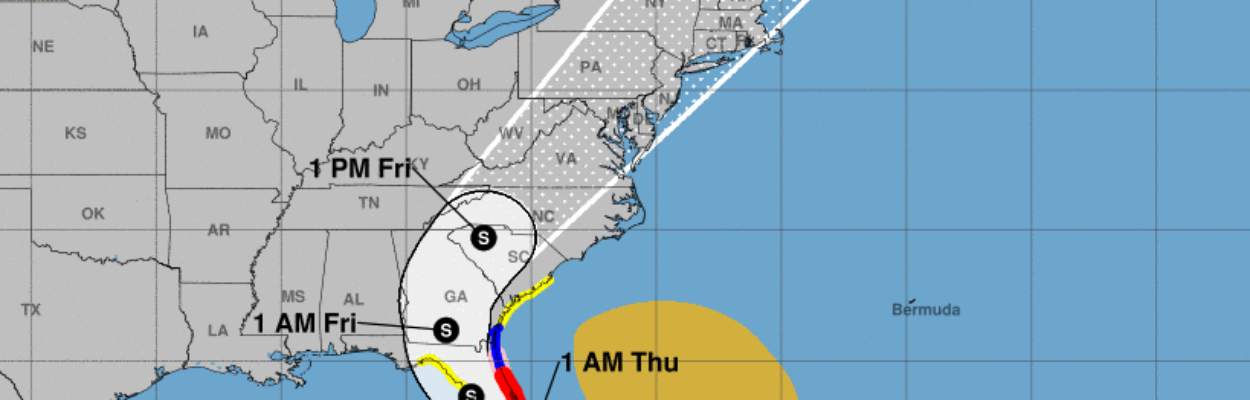
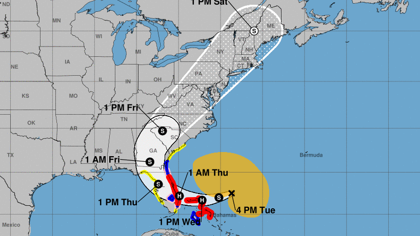
Tropical Storm Nicole, approaching hurricane strength, is bearing down on Florida, and a tropical storm warning has been issued for the First Coast.
A dangerous storm surge, with large and damaging waves, is likely along much of Florida’s east coast and portions of coastal Georgia, the National Hurricane Center said in an update at 11 a.m.
Jacksonville Today thanks our sponsors. Become one.
St. Johns and Putnam counties both recommended that people evacuate from areas at risk. A voluntary evacuation order covers coastal St. Johns County, including the entire city of St. Augustine, the city of St. Augustine Beach and people living in other waterfront property or flood-prone areas, beginning at 7 a.m. Wednesday.
Residents living on boats or in RVs, mobile homes and manufactured homes also were advised to evacuate.
In Putnam County, evacuations were recommended for residents of Zone F, including Sportsmans Harbor, Dunns Creek, Federal Point and other areas that experienced storm surge flooding during Hurricane Ian.

Jacksonville Today thanks our sponsors. Become one.
Nicole’s maximum sustained winds registered near 65 mph Tuesday afternoon, and additional strengthening is expected. Northeast Florida has a 50% to 70% chance of experiencing tropical storm winds, meaning 39 mph to 73 mph, the hurricane center said.
A hurricane warning was issued from Boca Raton to the Flagler/Volusia County line, with a hurricane watch north to Ponte Vedra Beach. Hurricane winds are 74 mph and above.
Rainfall could total 4 inches across the Jacksonville area and up to 6 inches in southern portions of Northeast Florida, the hurricane center said.

All of Northeast Florida remains in the forecast cone, and forecasters warn people not to rely on the cone as the storm’s exact track. The cone represents the potential path of the storm’s center, meaning it still could come ashore almost anywhere on the Florida coast.
Nicole is a large storm with hazards extending well to the north of the center, outside the cone, the hurricane center warned. Tropical-storm-force winds extend outward up to 380 miles from the center.
Atmospheric conditions are expected to steer Nicole westward to west-southwest during the next 24 to 36 hours, bringing the center near the northwest Bahamas on Wednesday. After that, the storm is expected to turn west-northwest as it approaches the Florida coast.
By late Thursday, Nicole is forecast to cross Florida and recurve back toward the southeastern U.S., possibly bringing it over Northeast Florida and southern Georgia.
Gov. Ron DeSantis issued a state of emergency in 34 Florida counties, including Clay, Duval, Nassau, Putnam and St. Johns counties.
Jacksonville Mayor Lenny Curry said Tuesday that he had not declared a local state of emergency. He said a decision will come within 24 hours.
“At this time, we are not closing city offices and departments opening shelters,” Curry said. “Nor are there mandates for any private businesses, and Duval County Public Schools is not closing schools.”
Out of an abundance of caution, however, the City has canceled the Veterans Day Parade and breakfast scheduled for Friday morning. The Greater Jacksonville Agricultural Fair also will close Thursday and operate with new hours Friday: 3 to 11 p.m.
The city asks all residents to clear any yard waste they may have before the storm arrives. For any non-emergency issue, call 6-3-0-CITY.
St. Johns County planned to open two shelters at 1 p.m. Wednesday and others if necessary. The shelters are:
- Health and Human Services Department, 200 San Sebastian View, St. Augustine, special medical needs.
- Solomon Calhoun Community Center, 1300 Duval St., St. Augustine, general population and pet-friendly.
For more information, call the St. Johns County Emergency Management Citizen Information Line at (904) 824-5550.Putnam County will open these shelters at 6 p.m. Wednesday:
- Middleton-Burney Elementary School, 1020 Huntington Road, Crescent City.
- Browning-Pearce Elementary School, 100 Marvick St., San Mateo.
- Ochwilla Elementary School, 299 State Road 21, Hawthorne, pet-friendly.
- Kelley Smith Elementary School, 141 Kelly Smith School Road, Palatka, special needs.
St. Johns County also announced Tuesday morning that it was providing free sandbags from 10 a.m. to 5 p.m. at three locations:
- Windswept Acres Park, 5335 SR A1A South
- North Beach Park, 3721 Coastal Highway.
- Palm Valley, Underneath the Palm Valley Bridge on the east side of the Intracoastal Waterway.
Distribution will continue beginning at 8 a.m. Wednesday as long as the weather allows. Residents must provide shovels and are responsible for filling their bags, up to 20 bags per person.
The Historic Downtown Parking Facility will be free starting at 5 p.m. Tuesday for residents living in low-lying, flood-prone areas who are seeking higher ground for their vehicles. Residents should plan to retrieve their vehicles once the storm passes, and it is safe to return home.
9(MDEwNzczMDA2MDEzNTg3ODA1MTAzZjYxNg004))