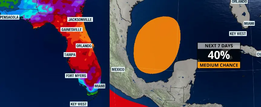
Rainfall totals forecast through Saturday morning (left) and area where there could be tropical development later on this week.
Published on October 5, 2026 at 9:52 am
Free local news and info, in your inbox at 6 a.m. M-F. Sign up for the Jacksonville Today newsletter.
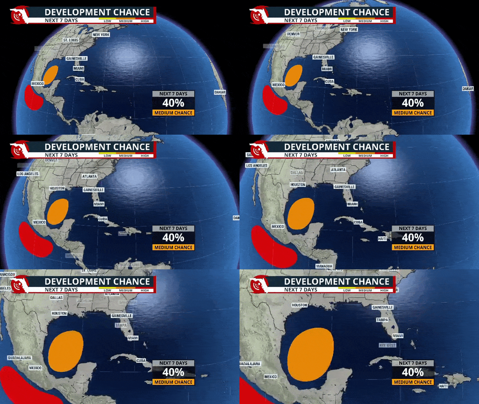
As we all know, hurricane season has been quiet across the Atlantic Basin. So far, the Atlantic remains on snooze, with no tropical systems currently being monitored. But a system could potentially develop later this week over the western Gulf.
As of Sunday evening, the National Hurricane Center gives this area a 0% chance of development over the next 48 hours and a 40% chance over the next seven days. These percentages will likely increase as the week progresses, especially the short-term probability.
Jacksonville Today thanks our sponsors. Become one.
To be extra clear, any development in the Gulf of Mexico will likely remain over this area throughout much of the workweek. Weather models differ on the strength and track of the potential low-pressure system.
Keep in mind that, as of Sunday evening, no system exists in the Gulf. Therefore, models are projecting a potential system that has not formed yet. Projected tracks could vary widely because, without a well-defined center of circulation, models cannot determine a track with high certainty.
This system, in its early stage, will battle strong north-northwest windshear, which will displace much of the convection southward, and some of the incoming front’s energy could catalyze development later this week.


Jacksonville Today thanks our sponsors. Become one.
We will continue to monitor this closely. For now, we should focus on the flash flood threat that will be present and expanding across the Florida Peninsula this week before anything potentially develops in the Gulf of Mexico.
Flash flooding in Jacksonville
The weather has been very active across the Panhandle, with flood watches continuing through at least Monday evening, extending from Pensacola eastward toward Jacksonville.
The highest chance of flash flooding will be across the Florida Panhandle. The flood watch in effect across parts of Jacksonville and the northern fringe of North Florida will remain in effect until Monday morning but could be extended later in the day.
According to the Weather Prediction Center, the Panhandle is under a slight risk of flash flooding, meaning there is at least a 15% chance of flash flooding within 25 miles of a point. From Tallahassee eastward, there is a marginal risk, meaning there is at least a 5% chance of flash flooding within 25 miles of a point.
From Monday through Tuesday morning, flash flood risk will continue across portions of the eastern Panhandle and North Florida. As the week progresses, the flash flood risk will extend into Central Florida and parts of South Florida while continuing across portions of Northeast Florida through at least Thursday morning.
How is the setup affecting Florida?
Throughout the weekend, a slow-moving cold front — the same front that brought flooding rainfall across Texas toward the end of last week — continued to push eastward.
Heavy rain affected the Panhandle and will continue to slowly spread east and south, covering much of the Florida Peninsula throughout the upcoming week. The issue is that this front will keep moving very slowly and is likely to stall around Lake Okeechobee toward the end of the week.
Rainfall totals
Between Monday morning and Saturday morning, rainfall totals across Florida will likely be most impressive in Northeast Florida. The Jacksonville area could accumulate between 5 and 7 inches of rain, with some isolated locations potentially exceeding 10 inches.
In the Panhandle, not including the rain that fell over the weekend, another 5 inches of rain could fall throughout the week.
Across Central Florida, rainfall totals will generally range between 2 and 4 inches, with some isolated locations — especially where storms become more persistent — potentially exceeding 5 inches.
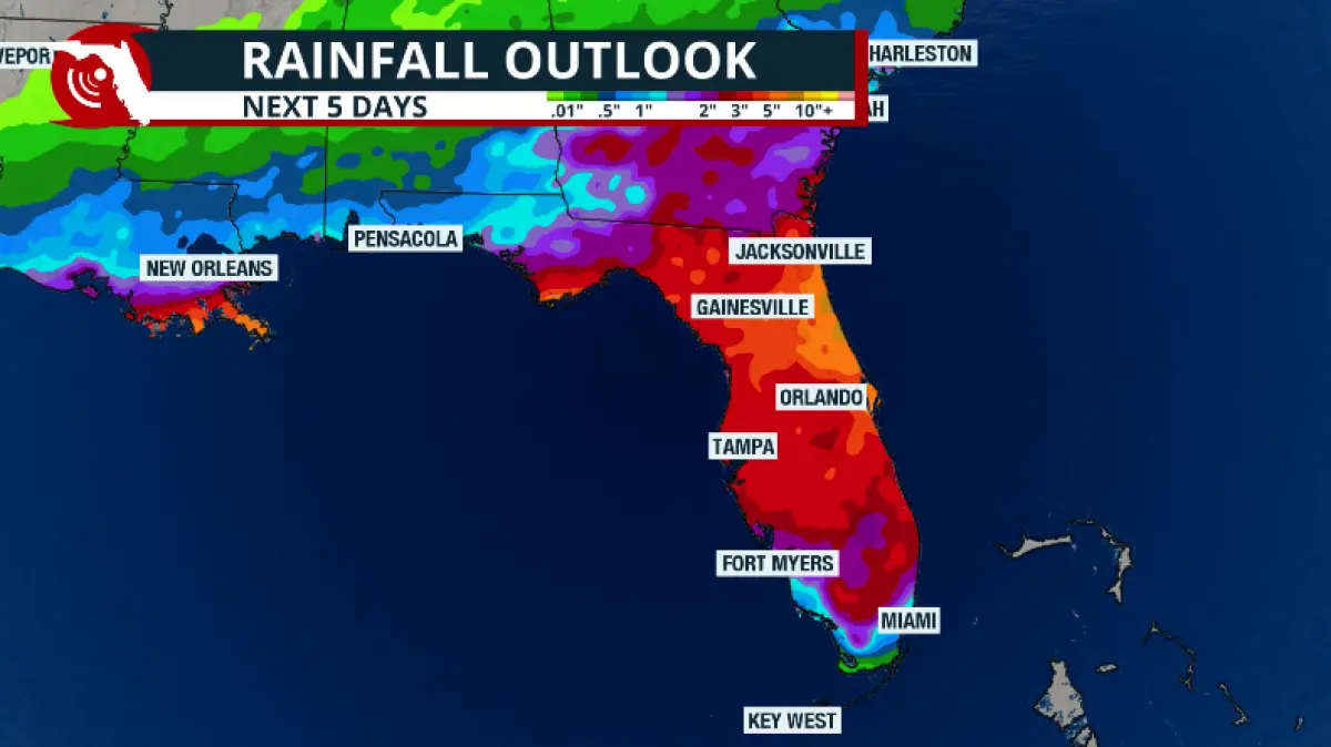
Across South Florida, Monday will start off mostly nice, with little chance of rain, as it was during this past weekend. Between Tuesday and Saturday morning, rainfall totals will likely be lower but should still range between 1 and 3 inches, though they could exceed 4 inches in some isolated locations.
Copyright © 2026 Storm Center