Published on April 30, 2026 at 9:33 am
Free local news and info, in your inbox at 6 a.m. M-F. Sign up for the Jacksonville Today newsletter.
A high-pressure system in the middle levels of the atmosphere continues to set up camp near Florida.
High-pressure systems act like a dome, bringing in sinking air. As air sinks, it warms, allowing temperatures to soar.
Jacksonville Today thanks our sponsors. Become one.
As sinking air increases, rain chances decrease. For it to rain, we need rising air.
This high-pressure system will continue to linger through the weekend. This is exactly why we forecast temperatures to remain hot through the end of the week and into the weekend.
However, this high will slowly shift south of Florida. This movement will allow another system to enter the Southeast — a cold front.


Jacksonville Today thanks our sponsors. Become one.
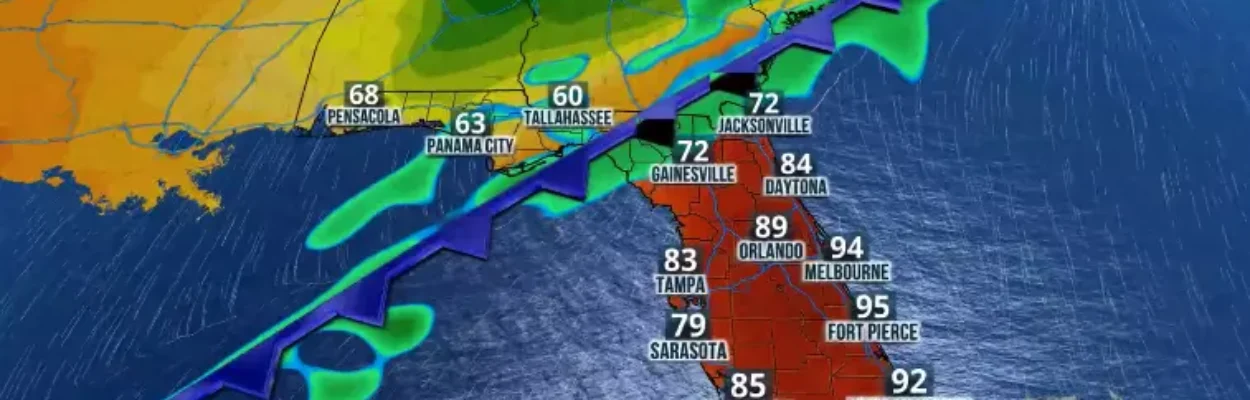
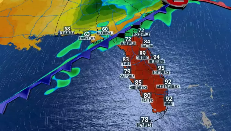
On Saturday, this cold front will begin to enter the western portion of the Florida Panhandle. Its arrival will enhance the potential for showers along the western portions of the Interstate 10 corridor.
As the day progresses, radar will begin to show showers across the Panhandle and North Florida. By early Sunday morning, showers should be moving into Central Florida, including the Tampa Bay area.
For South Florida, winds will mainly be out of the south-southwest, leading to very hot temperatures across Southeast Florida and the Treasure Coast. We are expecting near-record high temperatures, with many areas along the Interstate 95 corridor approaching 95 degrees. Cities such as West Palm Beach could challenge the record of 94 degrees set in 1929.
Still, on Sunday morning, much of the Lake Okeechobee region and western portions of South Florida, including Southeast Florida, should remain rain-free. By the afternoon, a few showers and an isolated thunderstorm may develop across the southern half of the peninsula. Rain is expected to continue across southern Florida and parts of the Space Coast into Monday morning.
The front will linger around the Lake Okeechobee area, bringing additional rounds of showers through Tuesday afternoon. Expect a few thunderstorms as well. Another round of storms is possible Thursday afternoon across Southeast Florida.
How much rain?
Through Tuesday afternoon, rainfall totals could reach around 2 inches across portions of the western Panhandle. Along the I-10 corridor, rainfall is expected to range between 1 and 1.5 inches.
Central Florida is expected to receive generally under an inch of rain along the Interstate 75 and I-4 corridors. However, as rain becomes more persistent across South Florida, some areas could receive between 1.5 to 3 inches of rain, with isolated spots reaching up to 4 inches.

Florida continues to deal with drought conditions. This rainfall could bring some minor relief to parts of the state, as reflected in the next U.S. Drought Monitor report to be released in early May. However, significant improvement is not expected, as Florida has been extremely dry and warm this week.
Keep in mind that the front will allow much drier air to filter in after its passage over North and Central Florida. A touch of cooler air will accompany it, and temperatures will feel really nice on Monday.

Copyright © 2026 Storm Center