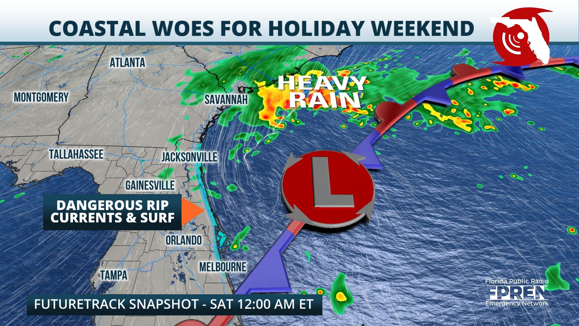
The Memorial Day weekend is here, and a developing area of low pressure is forecast to bring dangerous surf and high winds to Florida’s East Coast.
The National Hurricane Center has an area of development highlighted off the coast of the Southeast U.S. in their seven-day tropical weather outlook. This area, which stretches roughly from the Outer Banks of North Carolina to near Cape Canaveral, exhibits a low chance of development over the next week. Surface analysis Thursday depicts an area of low pressure located in South Florida, with several localized troughs of low pressure extending outward from the center. Over the next 24 to 48 hours, global forecast models indicate the development of a closed low offshore. A closed low is merely one characteristic of a tropical system, however, this does not mean the low that develops will take on other important distinguishing features. The latest NHC advisory explicitly states, “The system appears unlikely to become a subtropical or tropical cyclone since it is forecast to remain frontal while moving generally northward and inland over the Carolinas this weekend.”

Impacts will be felt across Florida’s East Coast, regardless of tropical or subtropical development. As surface low pressure deepens, or strengthens, high pressure is forecast to wedge down the Mid-Atlantic. These two features will act in tandem to bring gusty winds through the Memorial Day weekend, especially from Cape Canaveral northward. Models suggest by Friday evening, sustained northeasterly winds along the First and Space Coasts could reach as high as 25 to 30 miles per hour. Closer to the center of low pressure off the Southeast Coast, forecast wind speeds reach closer to 45 or 50 miles per hour. Based on forecast data as of publishing, the window for strongest winds will likely be Friday night into early Saturday. As the area of low pressure moves further away from the Florida coast, winds should ease into Sunday.
Memorial Day weekend is often viewed as the unofficial start to summer and many will be flocking to Florida’s coastline. The risk of dangerous rip currents will be high through Saturday evening, which could sweep even the best swimmers away from shore. Residents and vacationers are encouraged to practice beach safety and heed the beach flag warning system. Rip current risks are often accompanied by dangerous marine conditions and that holds true during the holiday weekend. Persistent northeasterly winds through Friday will result in dangerous surf, with Small Craft Advisories and Gale Warnings in place from the Flagler-Volusia County border northward through the First Coast. The Forecast Discussion from the National Weather Service in Jacksonville states that strong winds could lead to waves as high as 8 feet in the Small Craft Advisory and up to 14 feet in the Gale Warning. Dangerous wave activity could result in capsized or damaged vessels and reduced visibility Friday into Saturday. This system’s impact footprint will be felt as far north as New England, where rough seas are expected to make for dangerous boating conditions in coastal waters.
The potential for gusty winds and dangerous surf are enough to put a damper on any holiday weekend activities, but showers could also contribute to the less-than-ideal outlook. Numerous showers or thunderstorms are forecast to develop across the Peninsula Friday, especially along and south of I-10. By Saturday, shower chances should stay mostly confined to areas along Florida’s East Coast. A slight uptick in tropical moisture Sunday will likely result in more numerous coastal showers and storms, especially from Cape Canaveral through South Florida. The Memorial Day holiday looks generally dry based on the latest model guidance as of publishing, with South Florida most likely to experience scattered thunderstorms during the heating of the day.
9(MDEwNzczMDA2MDEzNTg3ODA1MTAzZjYxNg004))


