Published on July 27, 2026 at 10:33 am
Free local news and info, in your inbox at 6 a.m. M-F. Sign up for the Jacksonville Today newsletter.
Dangerously hot temperatures are sandwiched in the next week.
Thunderstorms threatened parts of the state Sunday, but heat advisories are in effect to start the week as rain chances diminish and temperatures become even hotter. The flood risk increases by midweek as numerous showers and storms return to the forecast.
A weak frontal boundary will push in from the north, and this could increase the chance of showers and isolated thunderstorms on Monday night. However, this will come after a very hot afternoon, when heat advisories are already in effect from 11 a.m. to 8 p.m. Monday.
Jacksonville Today thanks our sponsors. Become one.
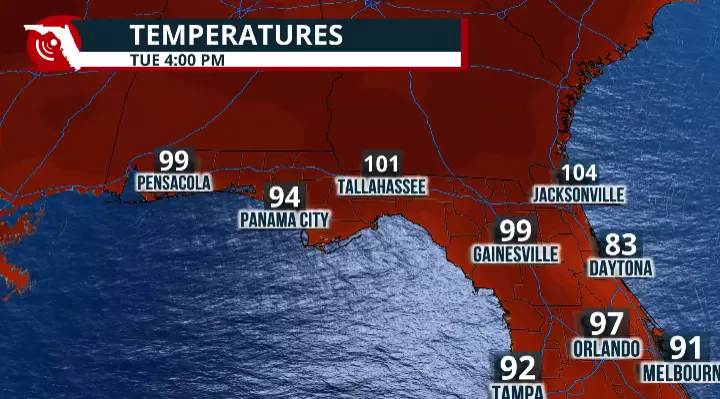
The National Weather Service in Jacksonville warns of temperatures from 95 to 99 degrees on Monday. The humidity will make it feel like 111 degrees, forecasters say.
Even hotter Tuesday
After Monday’s heat advisory, we’re already looking ahead to Tuesday’s extreme heat watch, which is in effect. This watch is likely to be upgraded to a warning, as heat indices could reach at least 113 degrees Tuesday afternoon during the peak heating hours, from 11 a.m. to 8 p.m.
Tuesday is likely to be a rain-free day with plenty of sunshine and lots of heat. Winds will be calm, making conditions even more uncomfortable outdoors.



Jacksonville Today thanks our sponsors. Become one.
Limit your outdoor activities, especially at the beginning of the week, as the hot temperatures could cause heat-related illnesses, especially for those taking certain medications, the elderly and children.
Rain chances increase beginning Wednesday afternoon with the return of downpours that could bring localized flooding across the Florida Panhandle, the Big Bend and North Florida through the middle of the week.
The increasing rain chances will mainly be due to a weak frontal boundary that will stall just north of the area and could produce enough instability and lift in the atmosphere to generate numerous showers and thunderstorms.
Tips to stay safe in the heat
- Drink water frequently, even if you don’t feel thirsty.
- Take breaks in the shade or in air-conditioned areas to cool down.
- Gradually increase workloads and allow more frequent breaks for new workers or those.
Heat sensitivity in children
Children’s bodies heat up faster than adults’, making them especially vulnerable to heat-related illnesses. If you’re a parent or caregiver, follow these safety tips:
- Touch the child’s car seat and seat belt before placing them in the vehicle to make sure they aren’t too hot.
- Never leave a child unattended in a vehicle, even for a minute or with the windows cracked open.
- Teach children never to play in, on or around vehicles. They could accidentally become trapped inside a hot car.
- Always lock your car doors and trunk, even when the vehicle is parked at home, and keep keys and key fobs out of children’s reach.
- Before leaving your vehicle, always check the back seat to make sure every child has gotten out. Never leave a sleeping infant or child in a parked car.
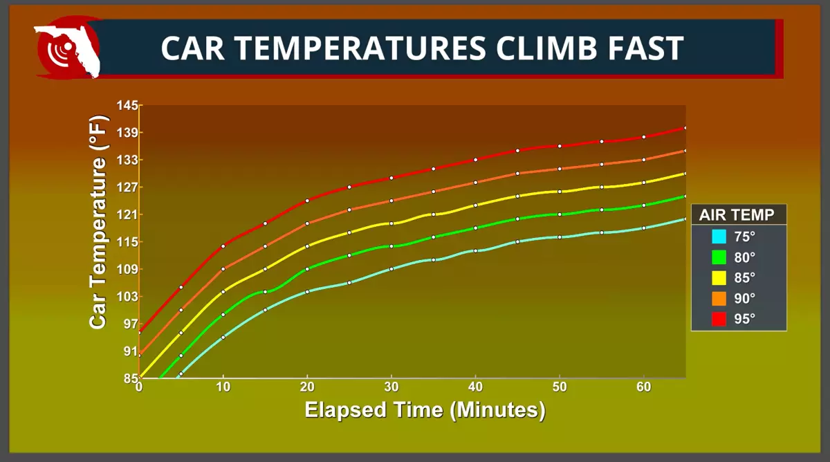
Remember: The temperature inside a parked vehicle can rise rapidly, becoming deadly within minutes, even on days that don’t feel extremely hot outside.
Copyright © 2026 Storm Center