Published on January 29, 2026 at 11:20 am
Free local news and info, in your inbox at 6 a.m. M-F. Sign up for the Jacksonville Today newsletter.
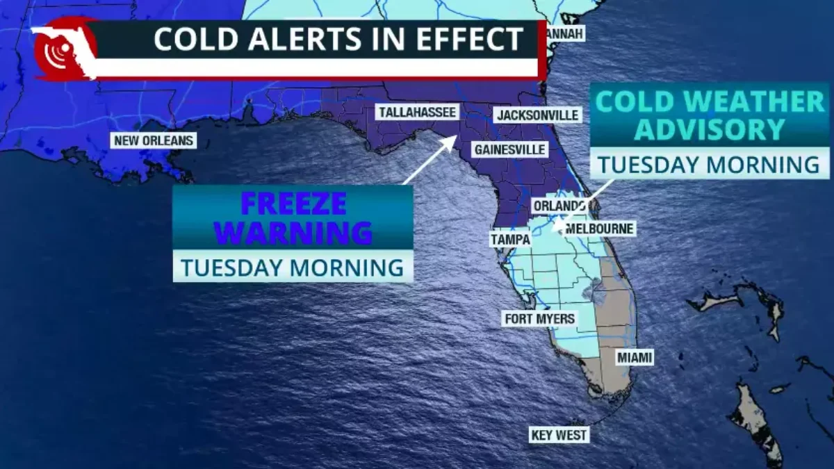
Florida’s cold snap continues across much of the peninsula, and the next cold front will bring very cold air over the weekend — likely the coldest in over a decade for many.
Across a peninsula, the winds will shift in the late afternoon Friday and start coming in from the southwest.
Jacksonville Today thanks our sponsors. Become one.
Temperatures on Friday afternoon will be much warmer than they’ve been throughout much of this past week. The high temperatures will likely hit 70 degrees across much of the peninsula, but stay between the low to mid 60s in North Florida.
But a low-pressure system will swing across the Gulf early on the weekend. This system will become stronger with the help of a low-pressure system in the middle levels of the atmosphere coming in from the north.
This low-pressure system in the upper atmosphere will bring Arctic air southward. The low-pressure system over the surface, moving in from the Gulf, will bring moisture across the peninsula.


Jacksonville Today thanks our sponsors. Become one.
The timing for the combination of the cold air and the moisture is critical for the chance to have winter precipitation or, at least, in typical Florida style, a few flurries.
At the moment, it seems like the moisture will move ahead and cross the peninsula before the cold air arrives. For winter precipitation, the entire atmospheric layer must remain below freezing for snow to fall.

If across different layers of the atmosphere, the temperature varies between warm and cold, meaning freezing and non-freezing temperatures, the state of the precipitation changes between liquid and frozen precipitation.
While the surface will continue to be above freezing for much of the peninsula, meaning all the precipitation will likely stay liquid, as rain, there could be a few flurries developing across Hillsborough County early Sunday morning.
If this were to happen, it would be because there could be enough moisture in the atmosphere created by the difference in temperatures between the Gulf waters (still warm) and the air coming in from the north, which, by this point, is very cold, to create a few flurries.

We do not expect measurable snow, as it will melt before hitting the surface, or as soon as it does. But if you happen to be out early in the morning on Sunday across parts of the northern Tampa Bay area, you could see a few flurries flying in the strong wind.
This will be a notable winter storm, pushing through Florida not only because it could bring the coldest air in over a decade for much of the peninsula, but the winds will be incredibly strong, especially on Sunday.
After the cold front pushes east, the pressure gradient — the difference in pressures between the low-pressure system to the east of Florida and a very strong high-pressure system from Canada over the Central Plains — could bring gusts above 45 mph along the entire Peninsula.
The wind will make the radical temperatures feel even colder. In fact, cities as far south as Ocala could have wind chill values as low as 9 degrees. Orlando could experience wind chill values between 10 and 12 degrees. Miami’s windshield could be as low as 27 degrees.
Miami has not experienced temperatures at or below 35 degrees since January 2010.
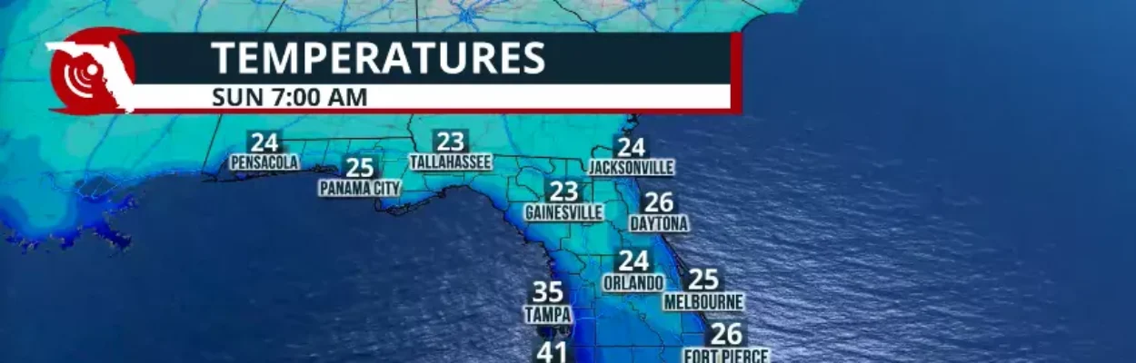
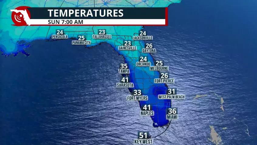
The actual low temperatures for Sunday morning will be around the mid 30s for South Florida, while temperatures between the Treasure Coast and North Florida will be between 25 and 21 degrees respectively.
The Tampa Bay area will likely remain in the upper 20s to low 30s. The Panhandle will remain the coldest, with actual temperatures in the low 20s.
Cold air is expected to persist on Sunday afternoon in many areas, and temperatures will not reach the 50s. South Florida is likely to stay around the mid-50s on Sunday afternoon, then have a warm-up through the first half of the week. Temperatures are expected to remain between 10 and 20 degrees below average through the first half of next week.

Cold weather safety
A simple way to prepare for cold weather is to remember the 7 Ps: people, pets, plants, pipes, pools, protecting vehicles and practicing fire safety.
- People: Cold temperatures increase the risk of hypothermia, especially for children, the elderly, and the unhoused. Wearing multiple loose layers, plus hats and gloves, helps retain body heat. Warming shelters typically open when temperatures fall below 35 to 40 degrees.
- Pets: Pets can suffer from frostbite and hypothermia. They should be brought indoors or given warm, dry shelter. Salt and deicers can irritate paws, so wiping pets’ feet after walks is recommended.
- Plants: Tropical, flowering, and newly planted vegetation is vulnerable to frost. Watering the soil before a freeze, covering plants, or moving potted plants indoors helps protect them. Frost and freeze alerts end once the growing season is over.
- Pipes: Frozen pipes are a major cause of winter damage. Pipes can freeze quickly when temperatures drop near 20 degrees. Insulating pipes, disconnecting hoses and letting faucets drip in very cold weather can help prevent freezing.
- Pools: Pools can freeze and be damaged in cold weather. Running the pump during freezing temperatures and maintaining proper circulation helps prevent ice damage.
- Protecting vehicles: Cold weather affects batteries, tire pressure and fluids. Regularly checking tire pressure, fluids and battery health helps keep vehicles running safely.
- Fire safety: Winter is peak season for house fires, often caused by heaters and fireplaces. Space heaters should be placed on nonflammable surfaces, kept at least three feet from combustibles, and monitored carefully. Chimneys should be cleaned annually, and smoke and carbon monoxide alarms are strongly recommended.