Published on September 26, 2024 at 1:09 pm
Free local news and info, in your inbox at 6 a.m. M-F. Sign up for the Jacksonville Today newsletter.
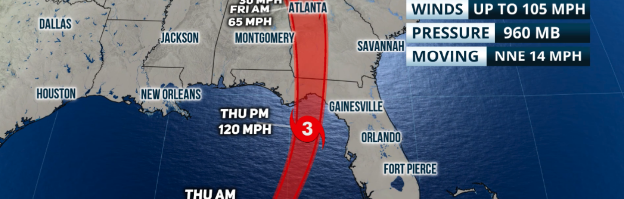
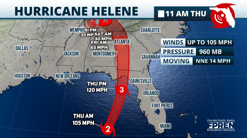
Hurricane Helene has strengthened into a Category 3 hurricane as it moves toward the Florida Big Bend and threatens Northeast Florida with wind, rain and flooding.
In a 3 p.m. advisory, the National Hurricane Center said Helene had become a major hurricane, with maximum sustained winds of 120 mph.
Jacksonville Today thanks our sponsors. Become one.
The hurricane has picked up some speed and has turned slightly toward the north-northeast at 20 mph. It is situated about 160 miles west-southwest of Tampa.
Speed will continue to increase gradually as the force of the hurricane is also expected to increase.
The latest measurements and images taken by the hurricane hunters and satellites indicate that Helene‘s eyewall has expanded and closed off. This is usually a sign of intensification. Helene is already a massive storm with a diameter of over 400 miles.


Jacksonville Today thanks our sponsors. Become one.
The Hurricane Center said Helene is one of the largest hurricanes in the past couple of decades. Storm surge, rain and winds will extend far from the center and well outside the forecast cone, particularly on the east side toward Jacksonville.
Hurricane-force winds extend outward up to 60 miles from Helene’s center and tropical storm-force winds extend outward up to 345 miles.

The Hurricane Center said Jacksonville has a 73% chance of experiencing tropical storm winds, meaning 39 to 57 mph. Winds are expected to die down as the storm moves into Georgia, but strong wind gusts are likely as far as northern Georgia and the Carolinas, with mudslides in the southern Appalachians.
Jacksonville officials have warned that trees could topple in high winds because recent rains have saturated the ground. A tornado watch has been issued for all of Northeast Florida and Southeast Georgia until at least 10 p.m. Thursday.
In a briefing Thursday, Angie Enyedi of the National Weather Service in Jacksonville said the strongest winds will occur from 5 p.m. Thursday to midnight.

“On the Westside, let’s say 30 to 40 mph sustained, and then we could see gusts up to 60 at times. But really the stronger magnitudes are going to focus more toward our open spaces like the riverfront and over toward the coast.”
Mayor Donna Deegan warned of wind and water damage in parts of Jacksonville.
Storm surge could reach as high as 3 feet as evening hours and high tide approach. The highest risks are along the St. Johns River north of the Buckman Bridge and into Downtown, San Marco and Riverside, with similar conditions during high tide Friday morning.
Deegan encouraged people to stay home Thursday night to remain safe.
Clay County officials said they were already starting to feel the effects at mid-afternoon Thursday. People need to remain vigilant overnight with the possibility of tornadoes, strong winds and some minor flooding, said Emergency Management Director Tim Devin.
“The western portion of our county will experience strong tropical storm-strength winds,” Devin said. “That means the Clay Hill, Keystone Heights and Camp Blanding areas are expected to see sustained winds of 58 to 73 mph and could see gusts increasing to 80 miles per hour. This could mean extensive or moderate impacts.”
Power outages and downed wires are expected. People can report downed wires at alert.claycountygov.com.
On the West Coast
The West Coast of Florida continues to feel the upper range of tropical storm-force winds and hurricane-force gusts. The winds will pick up promptly across North Florida within the next few hours and will continue to become even stronger as the afternoon and evening progresses.
Widespread power outages are likely across the Florida peninsula and North Florida. Helene’s wind field will continue to expand as the system moves northward.

Up to 20 feet of storm surge is still possible across the Big Bend and parts of the Apalachicola area. Up to 8 feet of storm surge is also possible across the west portion of Central Florida.
Large waves are already slamming against the West Coast of Florida, and waters will continue to rise as the storm moves northward.
Rainfall will be extensive, especially across the Panhandle. Flash flooding is possible, especially as Helene inches closer.
Power outages are increasing across the state. Currently, over 100,000 customers are without power, most in Southwest Florida. As Helene arrives and moves through, power outages will be widespread across the Panhandle.
Heavy rains will continue to move up the state. Some of these heavy rains have had thunderstorms embedded in them, and the National Weather Service issued several tornado warnings across South Florida and Central Florida on Thursday morning.
Information from Jacksonville Today reporter Steven Ponson was used in this report.
Copyright 2024 Storm Center


Randy comes to Jacksonville from the South Florida Sun-Sentinel, where as metro editor, he led investigative coverage of the Parkland school shooting that won the 2019 Pulitzer Prize for public service. He has spent more than 40 years in reporting and editing positions in Illinois, Iowa, Missouri, Ohio and Florida.