Published on June 5, 2024 at 11:16 am
Free local news and info, in your inbox at 6 a.m. M-F. Sign up for the Jacksonville Today newsletter.
Although temperatures have been hot this last week, they have at least remained closer to normal values for this time of year. This is all about to change starting Thursday as winds shift and mainly come from the south.
This change is in response to an incoming front that will continue to lose strength as it approaches Florida. The winds coming from the south will allow the temperatures to rise to the mid to upper-90s.
Jacksonville Today thanks our sponsors. Become one.
The heat doesn’t come alone, it comes with deep tropical moisture that will make conditions feel very muggy. Therefore, the temperatures will feel between 105 and 110 degrees across much of the state.

The mugginess will dominate much of Florida by Thursday morning.
By Friday, the winds will be mainly out of the southwest. This will bring all the heat, gathered over land, and dump it along the East Coast of Florida.


Jacksonville Today thanks our sponsors. Become one.
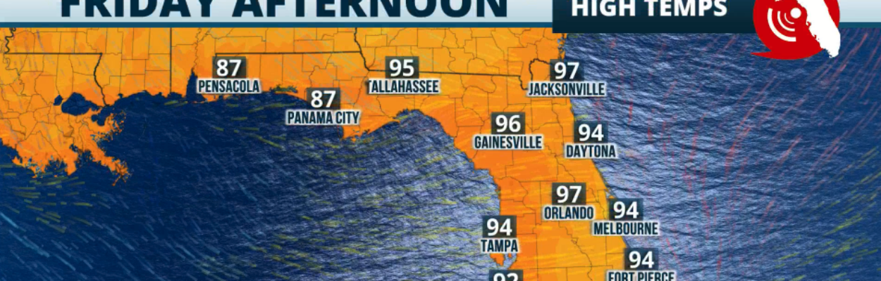
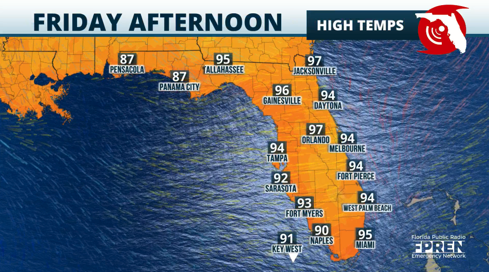
The National Weather Service in Jacksonville forecasts a high of 97 degrees on Friday with a change of thunderstorms. Miami and Fort Lauderdale could break new records, and the high temperature is likely to reach 95 degrees on Friday.

On Saturday and Sunday, record temperatures will be possible across the Interstate 4 corridor, from Tampa to Orlando, and along Interstate 95, from Melbourne to Miami. Jacksonville could wee highs of 95 degrees on Saturday and a scorching 98 degrees on Sunday.
Highs could range between 94 and 97 degrees across the state, and with the humidity the temperatures will feel as if they were above 105 degrees
Deep tropical moisture
If you’re wondering about the front mentioned before, do not expect it to bring any significant changes. The front will be losing intensity north of Florida.

We will have a deep tropical air mass arriving in the state late this weekend. This translates to numerous downpours and high rainfall from the start through the middle of the week.
We are monitoring closely the onset of the showers and their origin. As of now, most models show the highest rainfall across southern Florida. Some areas could receive up to 5 inches between Sunday and Wednesday. Check back by Friday as we will continue to bring you updates on the radio and this site.
Remember, hurricane season is here, and although we have started the season quietly without a named tropical system, things could quickly change. June storms tend to form closer to land from the remnant energy of frontal boundaries. So make sure you continue to monitor the weather closely. June is barely starting and June systems tend to be messy, not big wind makers, but high rainfall makers.

Copyright 2024 Storm Center