Published on May 23, 2024 at 10:37 am
Free local news and info, in your inbox at 6 a.m. M-F. Sign up for the Jacksonville Today newsletter.
The National Weather Service is launching a new heat risk forecast, a seven-day forecast to warn people of potentially long durations of dangerous heat events.
The forecast will gauge how unusual the heat is for that time of year, how long the heat is expected to last and whether temperatures will pose any heat-related effects.
Jacksonville Today thanks our sponsors. Become one.
The Weather Service is collaborating with the Centers of Disease Control and Prevention to provide health guidance for those most vulnerable to heat and may need to take extra precautions for their health when the temperature rises. According to the CDC, more than 1,200 people die from heat related causes a year. That’s more than floods, tornadoes and hurricanes combined.

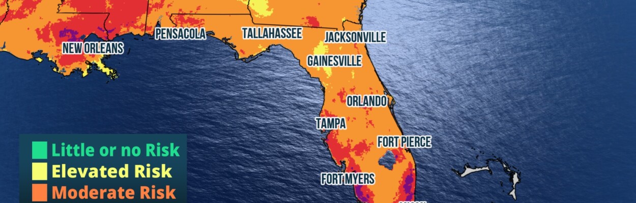
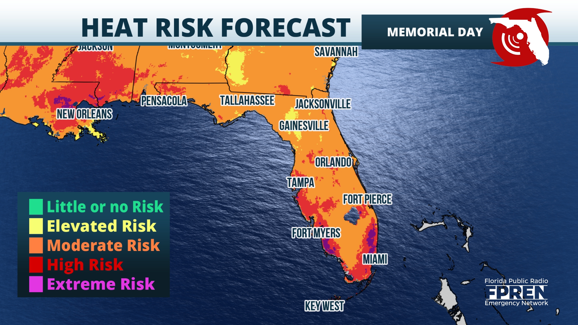
The Memorial Day three-day weekend is just a few days away, and if your plans include outdoor activities, expect hot temperatures across the state, with the possibility of thunderstorms in several locations.
The Panhandle can expect dry and warm conditions over the Memorial Day weekend, according to the National Weather Service, but heat indices could hit 100.


Jacksonville Today thanks our sponsors. Become one.
In North Florida, temperatures could hit the low to mid 90s by the weekend, according to Weather Service forecasters. The heat index could reach 100 to 104 by Memorial Day from the coast to the St. Johns river basin and north central Florida.
In Central Florida, there’s a “limited risk for excessive heat” starting late this week and into the holiday weekend. Temperatures are forecast to climb into the 90s, with heat indices reaching the low to mid 100s, according to the National Weather Service in Melbourne.
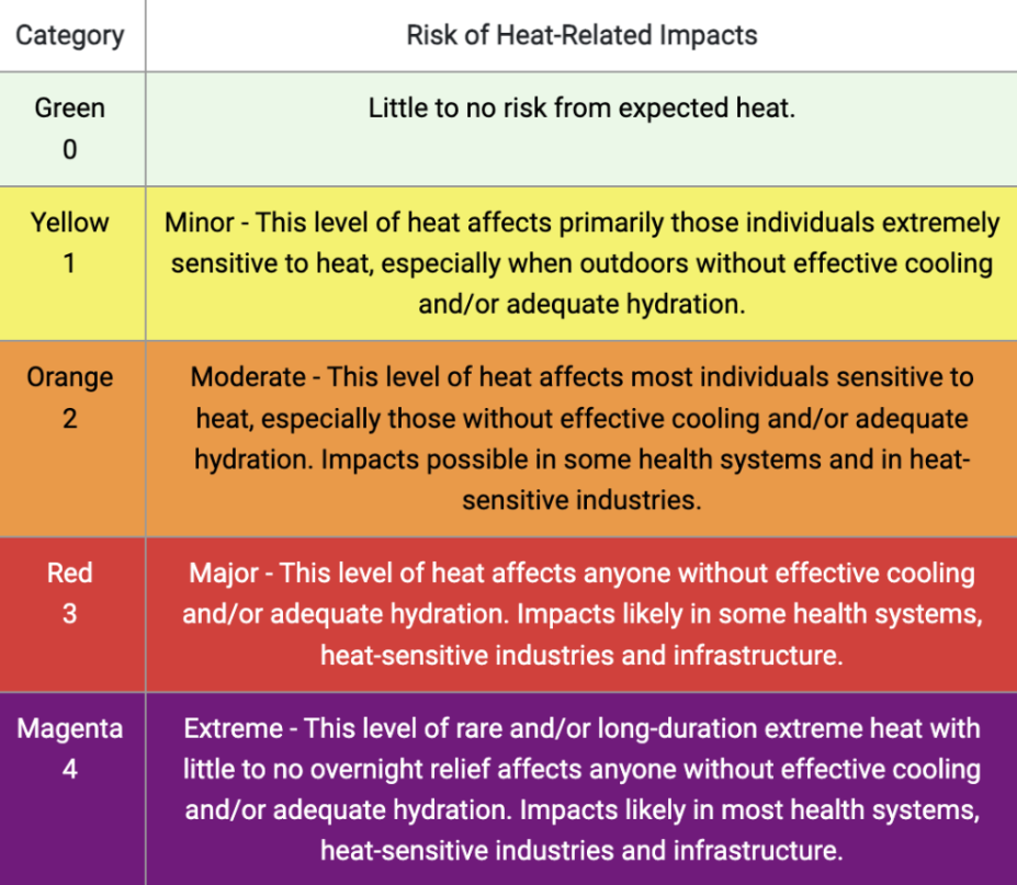
The Heat Risk color table ranges from light green to deep purple. Level 0 is the lowest risk for heat related impacts. Magenta is Level 4, which poses an extreme risk to high heat. There are five Colored Index categories from Minimal to Extreme.
“Ten of the warmest years on record have occurred from 2014 on,” Ken Graham, director of the National Weather Service. “So numerous studies have indicated heat waves. As you’ve already heard, heatwaves are getting hotter, longer, more frequent and you’re getting less relief at night. So it’s becoming increasingly serious.”
The Weather Service says it plans to work on messaging and social science feedback from the public to make sure the new Heat Risk forecast is easy for the public to understand. They also say it will be important to use social media as part of their awareness campaign to familiarize the public with this new forecasting tool.