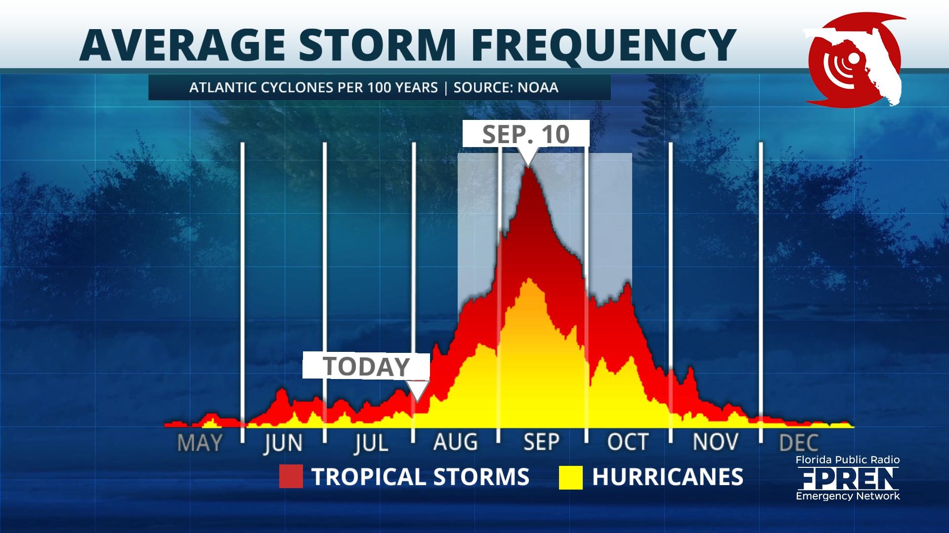
It was not a coincidence the director of the National Hurricane Center, Michael Brennan, jumped on YouTube Tuesday to make sure everyone is paying very close attention to the tropics. The month of August begins a rapid climb to the climatological peak of hurricane season on Sept. 10.
Historically, 90% of all hurricanes and 95% of all major hurricanes happen after Aug. 1 until the season officially closes out on Nov.30.
Although it is not unusual for June and July to be relatively quiet, this season has already had the fourth most active start of any season since 1851 with five storms and one hurricane. Today, Colorado State University updated its seasonal hurricane forecast.
According to Phil Klotzbach, a research scientist at Colorado State, “It’s the clash of the titans: record warm Atlantic sea surface temperatures and robust El Nino.” Today’s forecast continues to predict an above normal season and remains unchanged compared to last month’s outlook.

In April, the Colorado State group released its first forecast for season, which called for below normal activity. This report reflected anticipation that a developing El Niño would dominate the Atlantic Basin and inhibit tropical cyclone development.
However, those record warm water temperatures in the tropical Atlantic support above-average development of cyclones. As the forecast for historically warm waters in June and July verified, Colorado State upped its predicted number of storms accordingly, signaling this would likely overpower the effect of El Niño. Climatologically, as temperatures continue to increase entering August, cyclone development subsequently increases.
The Colorado State forecast update continues to call for 18 total named storms (tropical storms and hurricanes), five more than the normal of 14. Of those 18 forecasted storms, nine are expected to be hurricanes, and four of those are expected to be major hurricanes (Category 3 or higher). The average hurricane season produces seven hurricanes, three of which are major.
Naturally, there is still no way to be absolutely certain as to how El Nino and these incredibly warm sea surface temperatures will interact and eventually play out. Klotzbach stated that, “starting today and continuing every 2 weeks through mid-October, CSU will issue two-week forecasts … trying to pinpoint active vs. inactive parts of the season.” He also emphasized this is the 15th year that his group has issued sub-seasonal forecasts.
It’s important to understand this forecast is a prediction of hurricane season in its entirety. It does not predict when storms will develop, where they will develop or where they will track. States along the Gulf Coast and the Atlantic seaboard are encouraged to ensure their families and properties are prepared for potential tropical impacts this hurricane season.

Please download the Florida Storms app to stay aware at all times, and revisit this plan from Hurricane Preparedness Week to make sure you’re ready for whatever nature throws our way: https://fpren.prod.npr.psdops.com/2023-05-02/hurricane-preparedness-week-underway-with-goal-to-prepare-floridians-before-season-starts

9(MDEwNzczMDA2MDEzNTg3ODA1MTAzZjYxNg004))


