Published on February 19, 2025 at 9:31 am
Free local news and info, in your inbox at 6 a.m. M-F. Sign up for the Jacksonville Today newsletter.
The storm system that brought heavy snow and cold across the Central Plains will drag a cold front and storms across the Panhandle and North Florida late Wednesday night into Thursday.
Some isolated storms could pass through Central Florida by Wednesday afternoon as the cold front pushes through the Peninsula.
Jacksonville Today thanks our sponsors. Become one.
When the cold front gets closer to South Florida, there will be even fewer chances for isolated thunderstorms by Thursday morning. Nonetheless, a few showers could still fall across the southern area of the Sunshine State.

The big news about this front is that temperatures will be cold across North Florida, coldish across Central Florida and cooler in South Florida.
The National Weather Service in Jacksonville says locally heavy rainfall is possible along the Interstate 10 corridor Wednesday. Then a hard freeze is predicted Thursday night for inland Southeast Georgia and a freeze for inland Northeast Florida.


Jacksonville Today thanks our sponsors. Become one.
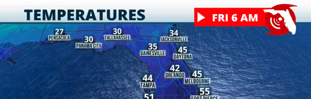
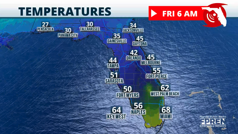
The coldest temperatures will be across the entire state on Friday morning. Across the Panhandle, some temperatures will be around the upper 20s to low 30s, and a few spots could develop a freeze or frost.
For Central Florida, low temperatures will be between the low 40s and mid-40s, with the coldest range dominating the rural areas.
For South Florida, low temperatures will be between the upper 50s and low 60s, with a few spots over Southwest Florida in the low-50s.
As the cold air settles in Thursday, it promises to be coolish in the afternoon in North Florida. But for the rest of the state, the coldest afternoons will be Friday and Saturday.
Central Florida, along the Interstate 4 corridor, will struggle to reach the mid-60s on Friday afternoon, with some spots into the upper 60s, mainly along the southern fringe from Melbourne through Sarasota.
For South Florida, high temperatures will stay in the low 70s on Friday and Saturday afternoons — all these are temperatures below normal for this time of year, between 5 to 15 degrees below average during the afternoon hours, while the lows will be up to 22 degrees below average for the Panhandle on Friday morning.
Temperatures are forecast to remain below average for this time of year throughout the weekend into early next week.
Remember that there will be strong winds after the cold front passes. The northern winds will keep very dry air in place, which could make some of these cool temperatures feel slightly cooler.
Also, the strong winds will bring hazardous marine conditions with seas that could be elevated on Friday and Saturday. Several small craft advisories could be in effect along the East Coast Beaches and the Gulf Coast.
Copyright 2025 Storm Center