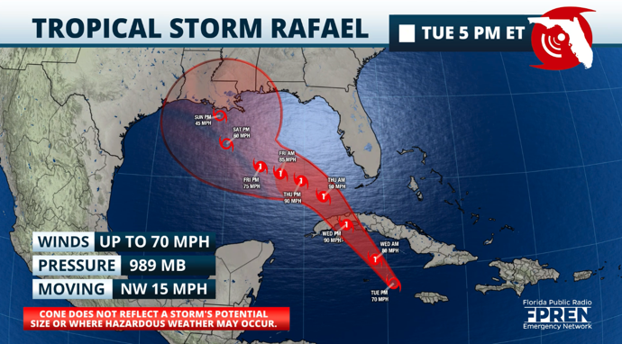
Tropical Storm Rafael continues to gain strength and is on the verge of becoming a Category 1 hurricane as it approaches the Cayman Islands.
It is possible that Rafael will undergo rapid certification between Tuesday night and Wednesday evening, and it could be a Category 2 hurricane as it nears the Isle of Youth in Cuba and the western portion of Cuba on Wednesday.
Rafael will be passing over Western Cuba on Wednesday afternoon. Friction with the terrain will likely weeken the hurricane, but it is still likely that the storm will remain a hurricane as it enters the eastern Gulf of Mexico.
The hurricane is currently moving at 15 mph. By Wednesday night, Rafael will start to slow down as it temporarily shifts to the west around the southwestern periphery of the high-pressure system that will keep the center of Rafael well away from Florida.
The relatively slow movement will allow Rafael to travel over the small spot of the Gulf current. This area of warm temperatures will allow Rafael to remain as a hurricane at least until Friday afternoon.

By Friday evening, Rafael will likely start making a northward turn and weaken rapidly.
The system will move over much colder waters and toward strong wind shear as it approaches the central Gulf coast. This will choke Rafael’s convection, but there will still be some winds.
Rafael will likely land in southern Louisiana on Sunday afternoon as a tropical storm with little rain and some wind gusts.
A tropical storm warning for middle and lower Keys of Florida.
Rafael rain bands will arrive in the Lower and Middle Keys on Wednesday. The rain bands could contain embedded storms, some of which could rotate, posing a risk of tornados.
For Florida, the good news is that Rafael will be turning westward — away from Florida.
Still, plenty of moisture will arrive on the peninsula between Wednesday and Thursday, bringing periods of heavy rains affecting much of Florida.

These showers and storms could create some flooding, mainly across the Keys, Southwest Florida, and to a lesser but still present extent, across west central Florida through the Panhandle.
Winds will remain gusty across much of Florida, mainly coming from the southeast and then from the South once Rafael enters the Gulf.


