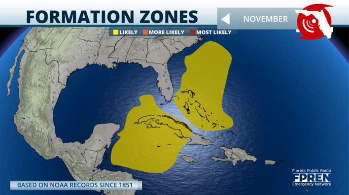
As we get ready to begin the last month of hurricane season, we start to look closer to land, where storms are more likely to develop.
When storms develop in these areas, they tend to turn east, but there are still a few instances when the shift doesn’t happen soon enough to avoid land.
The most favorable areas where storms usually develop are across the western Caribbean, in the western Atlantic by Florida and the Carolinas, and across the open Atlantic, north of the Caribbean.
As it happens during the season’s beginning, frontal boundaries often leave energy behind, leaving enough oomph for a quick storm to spin up.
Of course, there have to be other key features at play, such as enough warm water and low wind shear. Currently, we have warm waters, and the wind shear fluctuates.
The number of storms, on average during the last 100 years, that tend to form in the month of November tends to be much lower as we are coming down from the peak and ending the season.
Notable hurricanes and tropical storms have developed in November. Most recently, Hurricane Nicole in 2022 left miles of erosion along the east coast of Florida.
During the hyperactive 2020 hurricane season, Hurricane Eta made landfall in Central America as a Category 4 hurricane, causing torrential rains and landslides. Hurricane Gordon hit the Caribbean Islands and the Southeastern United States in November 1994, causing 1,147 deaths, including 1,122 in Haiti.
Are we monitoring any hurricanes at the moment?
The National Hurricane Center has no areas of concern at the moment, and no areas of concern could develop within the next seven days.

You might see some brief chatter about weather models showing development around the western Caribbean, but remember that this is just one model and only one run showing this formation.
This model has no consistency, and the European model shows no development. To post a picture of one model’s run would be speculation and show no validity as there is no context or validity.
We will continue to monitor all the features and bring you updates if something catches our attention. If it doesn’t catch our attention, you can rest assured that there is nothing to worry about.


