
Published on September 24, 2024 at 3:21 pm
Free local news and info, in your inbox at 6 a.m. M-F. Sign up for the Jacksonville Today newsletter.
Northeast Florida is preparing for high winds and possibly heavy rain as Tropical Storm Helene gains strength before landfall in Florida as a possible major hurricane on Thursday.
Jacksonville Mayor Donna Deegan warned residents to prepare for major winds and the possibility of falling trees from late Wednesday into Thursday.
Jacksonville Today thanks our sponsors. Become one.
“Our biggest concern during this storm is that we have such saturated ground, we are worried about trees falling over because we will have a lot of wind for a relatively short period of time, but still, that could cause us some problems with the saturated ground,” Deegan said during a briefing Tuesday. “The regular suspects that always flood may be an issue for some flooding, but beyond that, we are not expecting a crazy flooding scenario.”
Public schools in Duval, Clay and Nassau counties will close Thursday and Friday. Jacksonville city offices will close Thursday only. Clay County offices will close at noon Wednesday and remain closed Thursday and Friday.
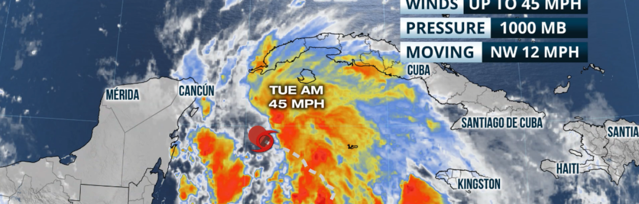
Helene was moving slowly toward the Yucatán Peninsula on Tuesday afternoon, but it’s expected to make a left hook toward Florida. The storm has maximum sustained winds of 45 mph and is moving north-northwest at about 12 mph.


Jacksonville Today thanks our sponsors. Become one.
The system is expected to lose forward speed Tuesday afternoon and overnight Wednesday. Starting Wednesday morning, the shift will be toward the north as it enters the Gulf of Mexico.
It is also during the overnight hours that Helene is expected to gain hurricane status during the overnight hours. Between Wednesday morning and Wednesday evening, the system will intensify rapidly and could be a Category 3 hurricane on Thursday with maximum sustained winds of at least 111 mph.
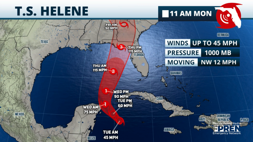
 Under the track issued by the National Hurricane Center at 11 a.m. Tuesday, Helene would be around 300 miles west of Naples on Thursday morning. Helene is forecast to make landfall along the Florida Big Bend on Thursday evening, likely as a major hurricane.
It is important to remember that impacts will extend far beyond the center of the storm, especially east of the center — including Greater Jacksonville — and may be felt across the state in some capacity.
Northeast Florida is expected to receive 2 to 4 inches of rain. Tropical storm-force winds — meaning at least 39 mph — are expected to arrive here during the day Thursday.
The National Hurricane Center says Jacksonville has a moderate risk of flash flooding over the next five days.
Local preparations
Florida State College at Jacksonville announced that all campuses and centers will be closed Thursdy and Friday. That includes online classes and administrative offices.
Duval Schools said all after-school activities as well as athletics will be canceled Wednesday through Friday. The district will decide later about potential makeup days.
The city’s storm shelters will open on Thursday, and JEA has added more crews to handle outages.
Shelters will be opened at LaVilla Middle School of the Arts, Atlantic Coast High School, Landmark Middle School and Chaffee Trail Elementary School.
More information about shelters can be found here.
St. Johns County will provide free sandbags from noon to 5 p.m. Tuesday and 8 a.m. to 5 p.m. Wednesday as long as weather permits. The locations are:
- Windswept Acres Park — 5335 State Road A1A South, St. Augustine.
- Solomon Calhoun Center — 1300 Duval St., St. Augustine.
- St. Johns County Equestrian Center — 8200 Smith Road, Hastings.
- Mills Field — 1805 Racetrack Road, St. Augustine.
- North Beach Park — 3721 Coastal Highway, Vilano Beach.
- Palm Valley Bridge — East Side of Intracoastal Waterway.
In the city of St. Augustine, all yard debris collection remains on schedule for Wednesday, and all recycling collection remains on schedule for Friday.
Clay County’s emergency management director, Tim Devin, said the county expects mainly gusty winds rather than flooding.
“We expect to see down trees and power lines as well as debris,” Devin said. “Please take this time to secure loose items and debris around your house and prepare for any power outages.”
County officials are urging residents who live in mobile homes, RVs and older homes to evacuate to one of the five shelters opening at 6 p.m. Wednesday due to the threat for tornadoes Thursday.
Helene’s effects
Although Helene will bring heavy rain, especially along the West Coast of Florida, the Panhandle and North Florida, the storm surge and huge wind field will grab most of the headlines. Widespread power outages are expected.
Storm surge could be as high as 15 feet along the Florida Big Bend through the upper area of the Tampa Bay. Across the Tampa Bay area, storm surge could be as high as 8 feet, and Southwest Florida could experience storm search as high as 5 feet in some spots.

The wind field is already large in Tropical Storm Helene, and this wind field will be expanding as it travels over the eastern Gulf of Mexico.
As of the latest advisory, tropical storm-force winds extend outward up to 140 miles to the east of the center. Keep in mind that Florida will continue to be east of the center, therefore tropical storm-force winds are likely across much of the state.
Rain bands will travel across the entire Peninsula. The most active day will be Thursday as heavy rainfall and thunderstorms embedded in these rain bands could also produce a few tornadoes.

Please finish preparations by Wednesday evening for anyone located from Central Florida northward. Weather conditions will quickly deteriorate throughout the day on Wednesday and become the worst on Thursday.
Flash floods are likely across the Panhandle along Interstate 10 from Tallahassee to Jacksonville and along Interstate 75 from north Florida to Central Florida, including Tampa.