Published on September 24, 2025 at 9:46 am
Free local news and info, in your inbox at 6 a.m. M-F. Sign up for the Jacksonville Today newsletter.
Hurricane Gabrielle could impact Europe, starting with the Azores Islands late this week, likely still as a hurricane, and the land in Portugal as an extra-tropical cyclone or tropical storm on Sunday into Monday.
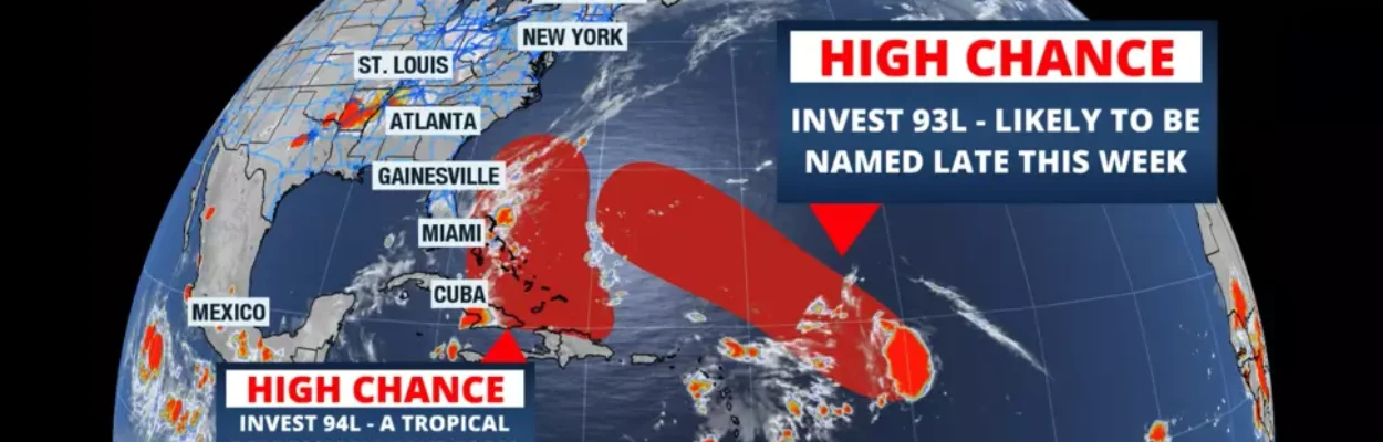
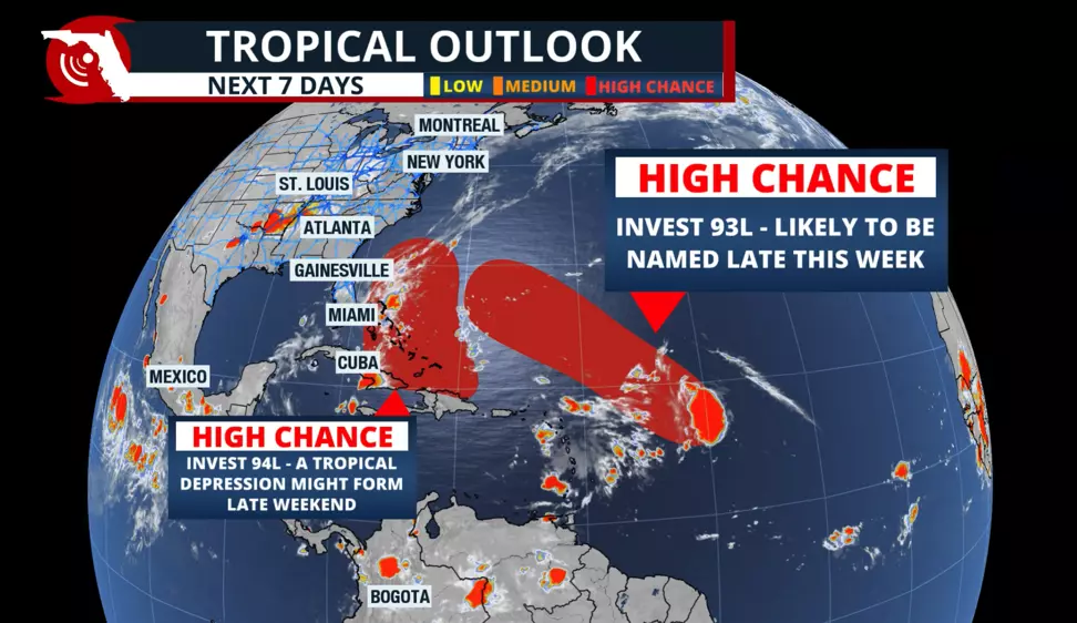
Closer to home, we are monitoring the next tropical disturbance, which has a high chance of being named by the weekend.
Jacksonville Today thanks our sponsors. Become one.
First, we have Invest 93L, which is about 750 miles east of the Leeward Islands. This system is the one that is likely to be named first.
Most models show that it could have a well-defined center of circulation by Friday. The next name on the list is Humberto. This disturbance moves west-northwest, staying north of the Caribbean.
Models have consistently shown that this system is likely to follow a similar path to Gabrielle, perhaps a bit more to the west, but not directly affecting the East Coast.


Jacksonville Today thanks our sponsors. Become one.
A more eastward path, and what appears to be a potentially larger system, could result in increased wave action, higher rip current risk and possibly beach erosion along parts of the Coastal Carolinas and the Northeast Coast.
It is too early to identify potential wave heights and locations that could be indirectly affected the most by this future system. Still, we will keep a close eye on it and bring you updates about Invest 93/future Humberto.

Invest 94 – a more southern track
The next tropical disturbance, which is passing over the northeastern Caribbean and bringing rounds of heavy rains from the northern portion of the Leeward Islands through Puerto Rico on Wednesday, is expected to continue hugging the north coast of Hispaniola before moving over the southern portion of the Bahamas over the weekend.
It is then that this system could become better organized, as it will be over water, and conditions could become more favorable for Invest 94 to intensify. This is the system that, if named, would be Imelda.
Models show two possible scenarios. The American model shows what would become Humberto staying stronger and bigger and making Invest 94/Imelda dance around it, absorbing its energy. This is what in meteorology is called the “Fujiwhara effect”.
The second scenario, the European Model, indicates that both systems remain relatively similar in size but remain separate. Invest 94/future Imelda would come closer to the east coast of Florida, but traveling northward parallel to the Sunshine State, while Invest 93 makes the turn northward.

At this point, it is impossible to know what the final track or outcome would be. What you must keep in mind is that next week is likely to bring rough seas along parts of the East Coast, and the waters are expected to remain hazardous through much of the week.
The good news is that we have a strong front expected to push these systems out to sea. However, we must monitor any slight delays in the movement of the fronts traveling cross-country, as a slight delay could mean a tropical system moving closer to home.
Preview for the start of October
Expect rainier-than-normal conditions through the first weekend of October and likely throughout the first week of the month. Plenty of humidity could be moving in from Central America.
Keep in mind that with deep moisture and sufficient energy remaining in the western Caribbean, storms can quickly intensify. So, tropical weather remains top of mind for the beginning of October.