
Snip20260109_5.png
Published on January 9, 2026 at 10:12 am
Free local news and info, in your inbox at 6 a.m. M-F. Sign up for the Jacksonville Today newsletter.
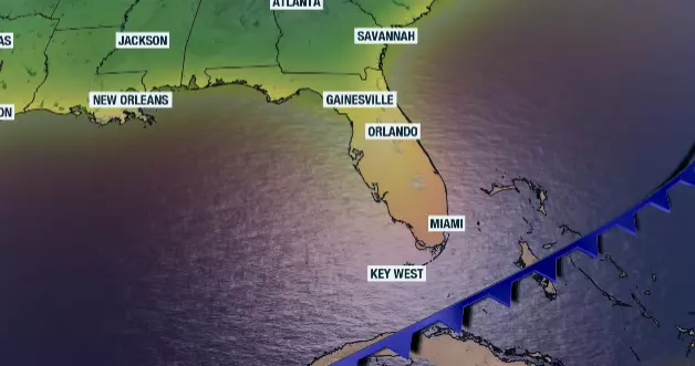
A cooldown is coming to Florida, but first we will have a warmer-than-average weekend, with afternoon temperatures about 10 degrees above average as south-southwesterly winds take over much of the state.
A cold front is forecast to start making its way across North Florida. It will bring rain on Saturday evening across cities such as Pensacola, Panama City and Tallahassee.
Jacksonville Today thanks our sponsors. Become one.
These will be some light to moderate showers. But as the front continues its trajectory toward and over the Peninsula, the rain line will become fainter, and there will be a lower chance of showers affecting Central Florida on Sunday.
For South Florida, the chance for a very isolated shower will arrive early Monday morning, between midnight and 6 a.m., so those who do get the rain will likely miss it. By afternoon, the front will slow and begin to retreat.
This is when parts of Miami-Dade, the upper Keys, and coastal Broward could have a few showers. The front will retract on Tuesday, likely increasing the chance of showers as moisture moves back north across parts of South Florida and Central Florida.
Jacksonville Today thanks our sponsors. Become one.
Cooler mornings will last too long, but at least the afternoons will remain closer to average for this time of year.

How long will the cooldown last?
Cooler weather will last longer across the Panhandle, with temperatures expected to fall into the 30s for at least 2 nights. Cold air will begin to move in on Saturday night and continue into Sunday morning across the western portion of the Panhandle.
There will be a sharp contrast between Pensacola, where Sunday morning will be in the mid to upper 40s, and Jacksonville, still in the low 60s. The cold front will be moving along Interstate 10 by this time.
Winds will increase after the front passes, with strong gusts on Sunday afternoon and evening across the Panhandle and North Florida.
Skies will be clearing, allowing temperatures to quickly fall into the 30s by Monday morning. The coldest night will likely be between Monday and Tuesday morning.
Pensacola thorugh Tallahassee will experience low temperatures between 36 and 39. Jacksonville will be in the low 40s.
In Central Florida, between Tampa and Orlando, temperatures will drop quickly on Sunday afternoon and evening. There could be a few spotty showers moving through, but the cooler air will filter in.
By Monday morning, lows will be between the upper 40s and low 50s. By this time, cold air will likely be over much of Florida, except in the immediate southeast, where lows will still be in the low 70s.
Monday afternoon will be in the low 70s across Southwest and Southeast Florida, in the mid-60s across Central Florida, and in the mid-50s across the Panhandle.
Keep in mind temperatures will moderate quickly, especially the lows across South Florida, as the front retracts, with increasing clouds and a chance of a few scattered showers. The afternoons will remain fresh across the Peninsula area in the 70s, while the Panhandle will enjoy cold mornings and cooler afternoons in the low 60s all week.
Another front could arrive late next week.
Copyright © 2026 Storm Center