
New Year's Eve fireworks over St. Augustine Beach.
Published on January 5, 2026 at 9:56 am
Free local news and info, in your inbox at 6 a.m. M-F. Sign up for the Jacksonville Today newsletter.
As 2026 gets underway, January’s weather patterns are shaping up to look strikingly familiar to what was largely experienced during the second half of 2025.
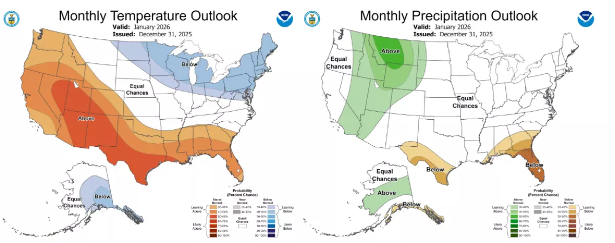
The January outlook from the National Oceanic and Atmospheric Administration shows warmer-than-average conditions over the Southeast, with precipitation values that are below average.
Jacksonville Today thanks our sponsors. Become one.
While cold snaps are still possible, the outlook suggests that warmer anomalies will outweigh cooler ones, resulting in warmer temperatures overall for the month.
According to NOAA forecasters, the outlook resembles a typical La Niña pattern for places such as Florida.
The status of the El Niño-Southern Oscillation, or what is commonly referred to as ENSO, is expected to warm over the coming months, leading to the world exiting the La Niña phases and entering a neutral phase.


Jacksonville Today thanks our sponsors. Become one.
Historically, La Niña winters often lead to less variabilities rather than a multitude of extremes.
Warm with wildfire risk
The drier precipitation outlook could also lead to significant effects across the region, despite January usually being a drier month.
Lengthy periods of 2025 went without precipitation, so the absence of rainfall in 2026 would add to existing deficits and minimal soil moisture.
A lack of precipitation would also lead to increased wildfire danger, similar to what was experienced just last year.
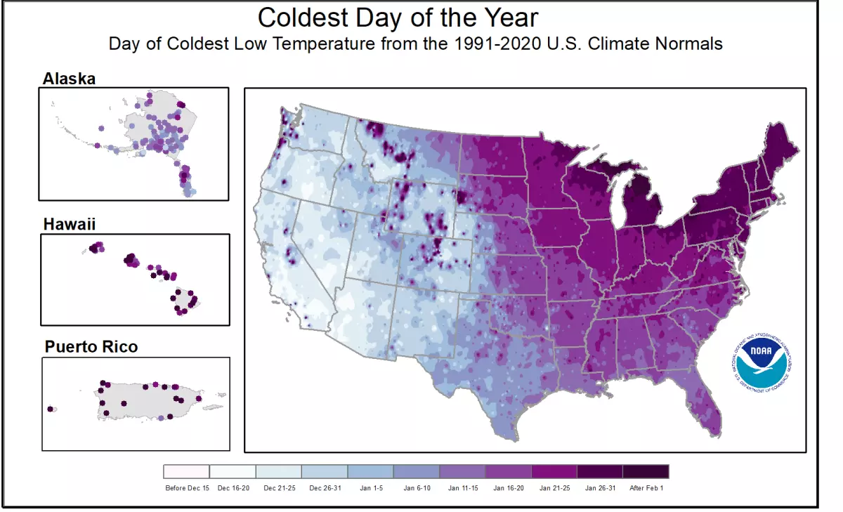
Typically, the third week of January is the coldest period of the entire year, and with the potential for warmer temperatures, it would likely result in meteorological winter finishing above average.
Seeing a warmer-than-average winter is not unusual, as every winter since 2013–14 has finished with above-average temperatures, including last season, which had an anomaly of 1.82 degrees above average across the nation.
A combination of climate models and forecasts involving winds around the poles and the status of the Madden-Julian Oscillation, or what is known as the MJO, gives forecasters confidence in projecting warmer-than-average conditions across the Southeast.
Not all regions of the country are expected to be as fortunate, as a large swath from the Northern Plains through New England is expected to see below-average temperatures.
Simultaneously, precipitation is expected to be at least near average, which would mean the region could be rather snowy at times.
January’s outcome has little bearing on what happens during February — the final month of meteorological winter — with four of the last 10 years actually ending with below average temperatures across the U.S.

Copyright © 2026 Storm Center