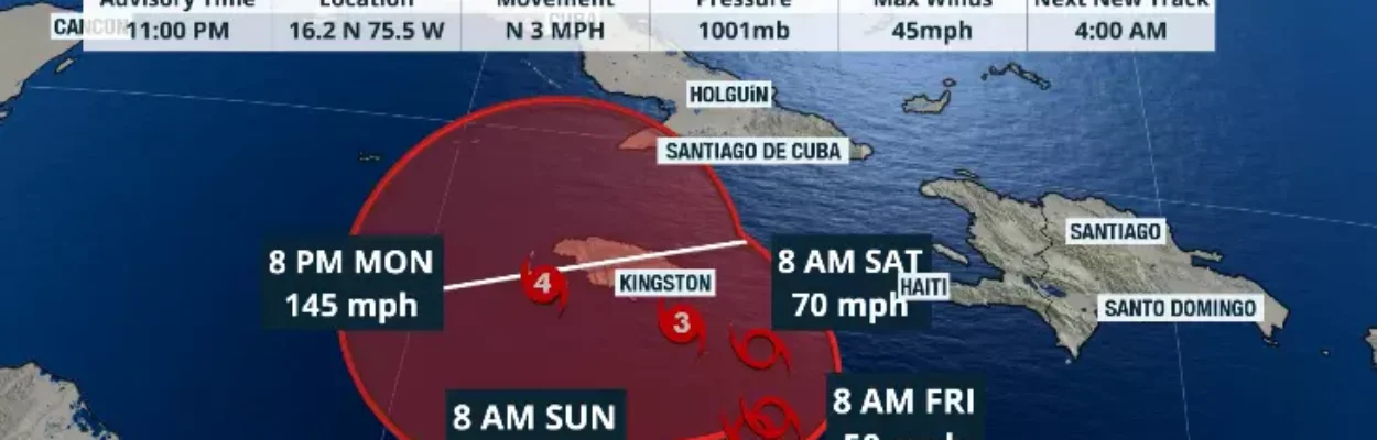
The path of Tropical Storm Melissa as of 11 p.m. Thursday, Oct. 23, 2025.
Published on October 24, 2025 at 11:02 am
Free local news and info, in your inbox at 6 a.m. M-F. Sign up for the Jacksonville Today newsletter.
Melissa remains a tropical storm over the Caribbean, moving at just 2 mph toward the north-northwest.
Tropical storm and hurricane watches have been issued for parts of Haiti and Jamaica. The tropical storm is already bringing heavy rains to Jamaica, eastern Cuba, southern Haiti, and the Dominican Republic.
Jacksonville Today thanks our sponsors. Become one.
This will be a historic storm, as rain has not stopped in parts of the Central Caribbean and is not likely to stop through the weekend. Melissa is forecast to continue moving slowly and intensifying, likely into the major hurricane category.
There is a risk of flash flooding and mudslides, as more than 12 inches of rain could fall locally in the coming days.
The capital of the Dominican Republic has recorded over 12 inches of rain, with 10 of those falling on Thursday. A dam in the central region of the Dominican Republic, known as the Presa de San Juan, is on red alert as water continues to rise.


Jacksonville Today thanks our sponsors. Become one.
There are no areas in the Caribbean capable of handling this amount of rain over such a short period, and the rains will continue. Rain bands could be strong at times, dropping several more inches of rain in short bursts.

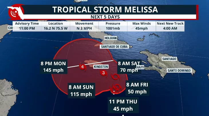
Melissa through Sunday
Melissa is over extremely warm waters, and this warmth is fueling Melissa’s intensification. The speed will remain slow at least until Saturday, when it will only pick up a bit, but will still stay relatively slow as it moves west.
By Saturday, Melissa should be a hurricane and will most likely intensify rapidly, reaching Category 3 or 4 hurricane strength.
It is possible that on Sunday morning, we could wake up to a Category 3 or 4 hurricane, and by Monday, Melissa could be a 5. Once the system makes the turn north, which is forecast for late Monday or Tuesday, it will accelerate.

Jamaica has some high terrain on its eastern side, but the weather also has some moderate mountains that reach a little over 2,000 feet. If the storm hits land, the mountains could have a slight impact, denting the system a bit.
But this hurricane will be powerful. It will likely arrive in Cuba near the middle of next week as a major hurricane, bringing torrential rains to the eastern portion of the Island. The Bahamas is also on the long-term path.
The storm is not and will not be a threat to Florida.