Published on September 29, 2025 at 9:52 am
Free local news and info, in your inbox at 6 a.m. M-F. Sign up for the Jacksonville Today newsletter.
Tropical Storm Imelda continues to move north at about 9 mph, and during the 5 p.m. advisory Sunday, it was about 355 miles southeast of Cape Canaveral. It is expected to continue intensifying and is likely to gain hurricane status by Tuesday night.
The good news is that the tropical storm watches have been officially discontinued by the National Hurricane Center. These were the tropical storm watches that were in effect from Palm Beach to the Flagler-Volusia County line.
Jacksonville Today thanks our sponsors. Become one.
There are no watches or tropical storm warnings or effects for any part of the continental United States. The warning that is in effect is for the Bahamas.

Imelda will continue to move north until Tuesday morning. But by Monday afternoon, the track is starting to show a more north-northeast turn, which will place Imelda about 200 to 250 miles east of Brevard County.
This is a safe distance; therefore, we’re do not expect the heaviest precipitation from the system or the strongest winds, although there will be an indirect impact on the East Coast of Florida.


Jacksonville Today thanks our sponsors. Become one.
Imelda will continue to be a rather messy system at least for the beginning of the week, while it remains a tropical storm.

Luckily, the strongest maximum sustained winds and gusts will remain focused to the east of the center, well away from Florida, even as the system’s wind field expands.
The east coast of Florida is likely to experience breezy conditions, especially until Monday night, before the system starts to take an easterly turn Tuesday morning.
There will be some isolated, heavy downpours moving in toward the coast, affecting the immediate coast, especially along the east central coast of Florida between Palm Coast and Port St. Lucie. This is where widespread rain is expected between Sunday and Wednesday, with a range of one to two inches.

Interior areas of Florida are likely to see more sunshine than rain, and with more sunshine, temperatures are expected to be hotter, at least through the first half of the week.
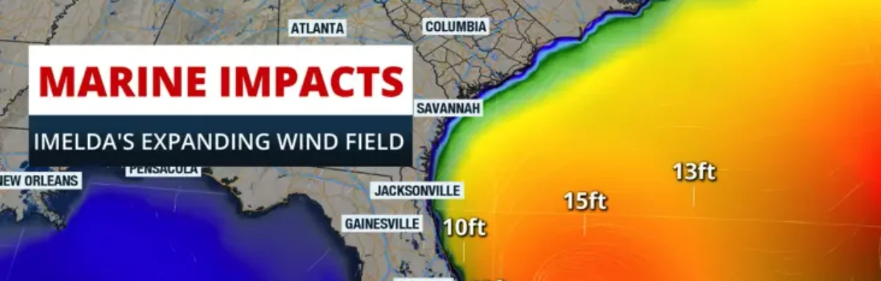
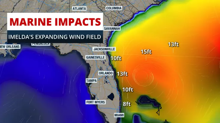
The biggest concern remains in the marine area. Please stay off the water. The seas will remain very dangerous throughout the first half of the week.
Winds are churning up the waters and creating high waves. Some waves could reach 12 feet, even closer to the shore, and higher seas are expected closer to Imelda’s center.
The highway waves, as well as the winds, could create beach erosion along the Florida East Coast. There will also be a high risk of rip currents to start the work week.
Please stay off the water and away from doing activities at the beach.