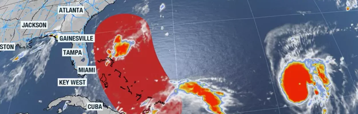
Satellite imagery shows Invest 94L and Hurricane Humberto on Friday, Sept. 26, 2025.
Published on September 26, 2025 at 9:39 am
Free local news and info, in your inbox at 6 a.m. M-F. Sign up for the Jacksonville Today newsletter.
Hurricane Humberto gained strength Friday, but a potentially more impactful disturbance is festering near Hispaniola and could become Imelda.
Humberto became a Category 1 hurricane Friday morning and is expected to pass safely north of the Lesser Antilles over the weekend.
Jacksonville Today thanks our sponsors. Become one.
According to the National Hurricane Center, Humberto is projected to intensify into a major hurricane, with maximum sustained winds of at least 130 mph within the next several days.

The storm is riding along the periphery of a ridge of high pressure, a pattern that will continue to steer the storm on a northwesterly trajectory.
Forecast guidance indicates Humberto should pass between Bermuda and the East Coast of the United States next week, keeping the cyclone’s center more than 500 miles offshore.


Jacksonville Today thanks our sponsors. Become one.
Even so, the hurricane is expected to generate significant swells and rip currents that will spread outward and reach the Southeast coastline.

While Humberto does not pose a direct landfall threat to the U.S., its intensity and position could influence the track of another system that has drawn the attention of forecasters — Invest 94L.
The future of possible Imelda?
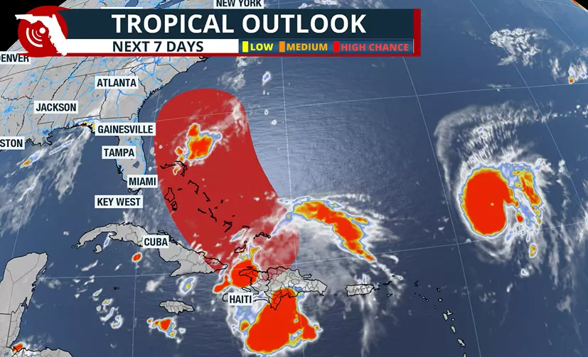
The Hurricane Center continues to monitor Invest 94L, the area of disturbed weather situated between Haiti and the southeastern Bahamas, but it continues to lack a center of circulation to be classified as a tropical cyclone.
As of Friday, the system has been given a 90% chance of developing into a tropical depression or tropical storm within the next several days.
Computer forecast models have been fairly consistent in moving Invest 94L slowly north to northwest across the Bahamas this weekend.

Beyond the weekend, the system’s future track becomes more complex as computer forecast models continue to diverge into two primary camps.
One scenario sends the system toward the South Carolina or North Carolina coastline as a strengthening tropical cyclone, while other computer models keep the system just offshore the Southeast before eventually pushing it eastward into the Atlantic.
Humberto’s evolution may play a major role in determining which path Invest 94L ultimately takes.
If Humberto grows into the dominant weather feature over the western Atlantic, its circulation could tug Invest 94L away from the U.S. coastline. However, if Humberto fails to exert any type of influence, the Southeast could face its most serious tropical threat of the season so far.

Small changes in either of the systems’ structures or positions could dramatically alter the outlook for the Southeast coastline.
For now, residents and beachgoers along the Atlantic coast are asked to pay close attention to the tropics this weekend as the forecast is fine-tuned and potential impacts come into focus.