Tropical Storm Erin as of 11 a.m. Monday
Published on August 11, 2025 at 12:08 pm
Free local news and info, in your inbox at 6 a.m. M-F. Sign up for the Jacksonville Today newsletter.
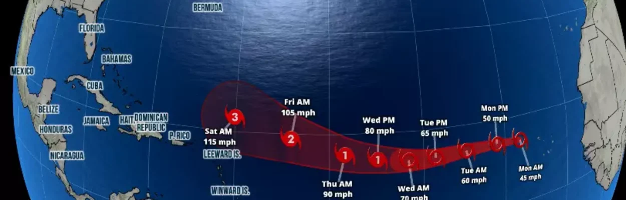
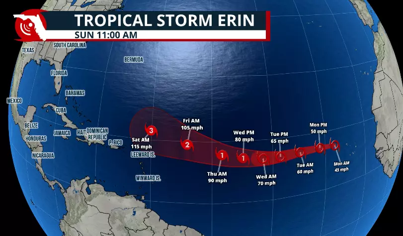
The tropical wave that has been a significant cause of speculation during the past few days has officially been named Tropical Storm Erin.
Erin is the fifth named system of the season and puts us ahead of average formation dates.
Jacksonville Today thanks our sponsors. Become one.
Also, this system is likely to become a hurricane later this week. The average date for the first hurricane is Sept. 1. If Erin does become a hurricane this week, we will be about two weeks ahead this season.
Tropical Storm Erin holds maximum sustained winds of about 45 mph and is expected to continue gradually gaining strength as it moves west at about 20 mph. This system is currently fighting dry air, and it is also traveling over a region of slightly cooled waters.
Hence, its intensification is somewhat limited over the next two days or so. By the end of the week, the system could be a major hurricane as it continues to move over the central Atlantic, the National Hurricane Center says.

Jacksonville Today thanks our sponsors. Become one.
Keep in mind that this system is over 2,000 miles away from the United States. It is currently bringing in heavy rains and locally strong gusts across the Cabo Verde islands, near Africa.

Meteorological models show the system, on a westward track, is staying south of the Bermuda High periphery. Systems that are this far away from the Western Hemisphere could take over eight days to come closer to land. This is, of course, if it were even to come closer to land.
Most models keep the system just north of the Caribbean. The northeastern portion of the Lesser Antilles should monitor this system very closely. But the two most reliable models, which are the American and the European model, place this system just to the northeast of Puerto Rico next weekend.
If this scenario materializes, the high-pressure system will be shifted westward closer to the Azores. This means that the system will likely turn and stay over the open Atlantic waters well away from the United States.
We do need to monitor the high that could build over the Gulf of Mexico and see where it is going to shift eastward. We have plenty of time to monitor the system and the weather patterns around it that could influence its track.
Be aware that the weather pattern could change in over five days. Models show only guidance this far away. Each system needs to be monitored closely, especially as the system comes together and becomes a well-defined system.

The good news is that when these systems intensify so far away from the Americas, they do tend to turn northward. When systems stay weaker, they tend not to be so easily guided by the Bermuda high, often continuing westward.
Of course, it is way too far ahead to know an exact location for the system seven days in advance.

We will continue to monitor the situation and the weather happening across our state this week, which has nothing to do with Erin. We have a trough over the Southeast producing plenty of showers and thunderstorms across Florida.
We expect the heat and sea breeze to contribute to the formation of thunderstorms for the first half of this week. There could be some spots that flood, especially over areas where heavier downpours persisted this week, like in Southwest Florida.