Snip20250629_2.png
Published on June 30, 2025 at 9:38 am
Free local news and info, in your inbox at 6 a.m. M-F. Sign up for the Jacksonville Today newsletter.
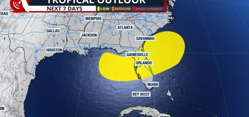
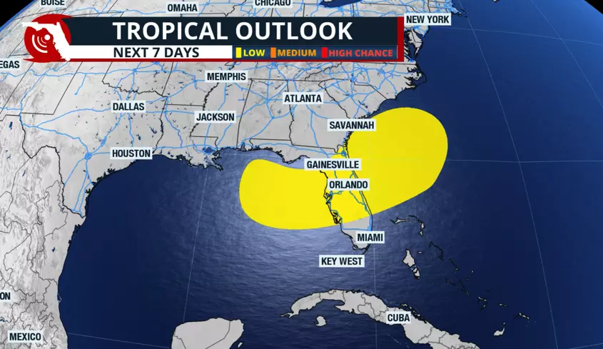
An area in the eastern Gulf and the western Atlantic could experience tropical development over the next seven days, possibly dampening the holiday weekend.
The National Hurricane Center says there’s a 20% chance of development over the next seven days.
Jacksonville Today thanks our sponsors. Become one.
In the short term, this area is unlikely to experience tropical development. However, we can expect an increase in the possibility of showers and thunderstorms due to a low-pressure system in the upper levels of the atmosphere, which will enhance instability in the area between Tuesday and Thursday.

We are closely monitoring a frontal system that will slowly move eastward over the nation. The tail end of this front could leave enough energy behind near Florida, and this is the energy that could ignite a tropical system.
The models disagree on this exact point about where tropical development could occur.

Jacksonville Today thanks our sponsors. Become one.
The American model depicts a very broad, yet undefined, center of circulation. This wide area of low pressure would form west of Florida over the eastern Gulf.
The European model shows a low-pressure system remaining east of Florida, about 200 miles east of Cape Canaveral. These two models represent two very different scenarios; they could produce opposite results regarding the weather for the holiday weekend in Florida.

If the American model verifies and a storm develops over the Gulf, there could be increased rainfall activity for the Florida peninsula during the holiday weekend. If the European model is confirmed, conditions are likely to remain drier than normal for the July 4th weekend.
We must continue to monitor the progress of the frontal system, which will inject and deliver sufficient energy near Florida. At this point, it is impossible to know precisely where, and if, a storm could form.