Published on May 12, 2025 at 11:00 am
Free local news and info, in your inbox at 6 a.m. M-F. Sign up for the Jacksonville Today newsletter.
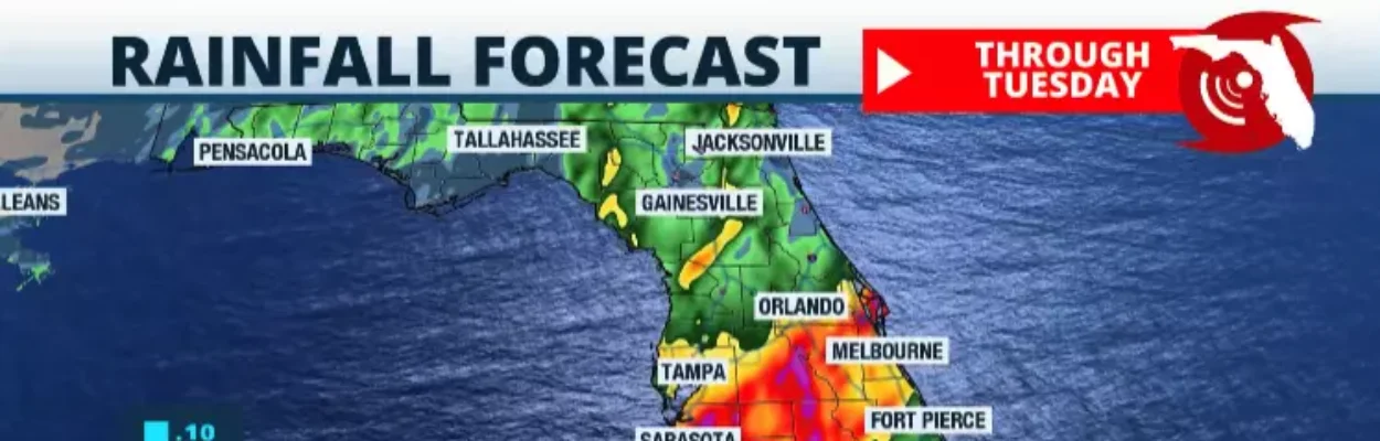
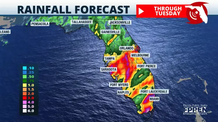
Heavy rain and a risk of flash flooding are possible in areas of North Florida into Tuesday.
The region is closer to a low pressure system spinning just to the north. Therefore, several storms will train one after the other, likely during a longer stretch than in different places in Florida.
Jacksonville Today thanks our sponsors. Become one.
Some areas in North Florida could experience 2 to 4 inches of rain. These areas have received rainfall in the last few days. Therefore, the ground, although also dealing with a drought, is sore from recent rains, and some spots could be saturated.
Flash floods are extremely dangerous as they often catch many people off guard due to the water rising rapidly in a short amount of time.
If you encounter flooded roads, please stay away from them. Remember the saying, “Turn around, don’t drown.” Floodwaters could be deeper than expected, even when traveling over familiar areas. Six inches of water could make your vehicle stall. Twelve inches of water could float a car.


Jacksonville Today thanks our sponsors. Become one.

For South Florida
The most intense weather will enter Southwest Florida overnight into the early morning hours on Monday. Heavy precipitation and the chance for severe thunderstorms will likely occur across Southwest Florida between 3 a.m. and noon.
The most dangerous time frame for southeast Florida will be between 9 a.m. and 3 p.m. Here, torrential rains will likely fall over highly populated areas, producing flash floods.
Rain totals across South Florida will be between 3 and 6 inches. Isolated spots could reach eight inches.
For Central Florida
Several flood advisories could be issued for Central Florida. This peninsula region has received heavy precipitation over the last few days due to the sea breezes igniting strong to severe thunderstorms. Rainfall totals across Central Florida will range between 2 and 4 inches. However, there could be some isolated areas that could accumulate up to 7 inches.
The weather will gradually become more stable on Tuesday. However, deep moisture will still flow across parts of South Florida, which could lead to isolated storms, especially on Tuesday.
Wednesday is when we’ll see the most significant improvement in weather as the sun returns, but the warmth will stay in place. Highs across South Florida will remain in the upper 80s, while Central Florida will also experience warm temperatures close to the upper 80s.