For people traveling to end the year somewhere else, keep a close eye on the weather forecast. Rain and snow will fall across the Appalachians to end the year.
At the same time, the same system will likely bring rounds of rain and a few thunderstorms across the Tri-state region and push northward toward New England just in time to ring in the New Year.
2025 will start with a few snow showers falling over the Blue Ridge Mountains and across Upstate New York through eastern Ohio, where the wind will also be gusting strongly, up to 40 mph.
The same system that will bring the chance for thunderstorms across the Northeast will leave gusty winds for New Year’s Day, making the already cold temperatures feel even chillier.

The Pacific Northwest will deal with showers and snow starting the afternoon of New Year´s Eve. There could be some travel delays as the next system arrives and penetrates deeper inland, producing stronger showers and storms along the coast, while more snow showers are in the forecast for the northern Rockies through the High Plains to start the New Year.
Aside from the precipitation on both northern corners of the nation, the big news will be across the Plains and how much the temperatures will plunge to start 2025 across the Southeast.
Low temperatures will go from 15 to 20 degrees above average for this time of year across the Plains and East to 10 to 15 degrees below average for the first weekend of the year.
One area hugely warmer than average for this time of year is the Northeast, specifically Upstate New York and Vermont, where temperatures on Monday morning were up to 50 degrees above average.
The cold will take its sweet time to arrive, and temperatures will gradually fall, reaching closer to average ranges, around 6 degrees next Monday morning.
Not traveling? Here’s what to expect in Florida
The drought has worsened in South Florida, but Sunday’s rain might have made a small dent. The new drought monitor will be released on Thursday,so we will know how much, if any, has improved.
The year ends with above-average temperatures across the entire state. The northern half of Florida will experience highs in the 70s, while South Florida could reach the low-80s as the west winds bring warmth and humidity.
By Wednesday, when the first cold front moves through, temperatures will respond as the colder air arrives by the afternoon across the Panhandle and North Florida. Highs will be in the low to mid-60s.
There is not much moisture coming along with this front, and the next front that pushes through on Thursday will reinforce the cold and dry air across the state.
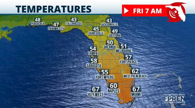
Thursday and Friday morning will be chilly, with temperatures around the mid-30s for the state’s northern half, while South Florida will be between the upper-50s and low-60s.
The third front arrives on Saturday, causing temperatures to plunge even further. Afternoons will be colder, with highs in the low-60s across the Panhandle and North Florida, in the mid-60s for Central Florida, and in the low-70s for South Florida.
Strong winds will make these temperatures feel colder. The winds will also bring rough conditions to both coasts starting Wednesday evening and likely continuing through the weekend.


