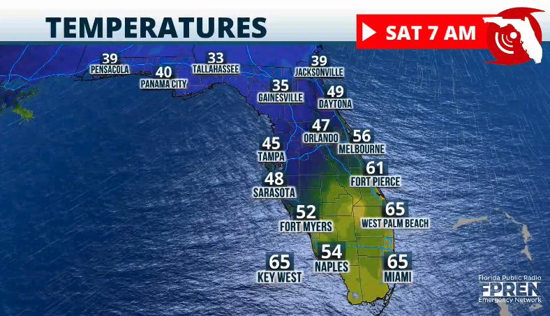
Another cold front will push through the Florida peninsula Friday. Expect a brief cooldown before temperatures start to rise again.
Early Friday morning, showers could move through the Florida Panhandle and North Florida. This is all associated with a cold front that will finish sweeping through the state, specifically across the southern portion of Florida late Friday evening.
This means that temperatures will take another plunge in North Florida. By Saturday morning, expect temperatures between Pensacola and Jacksonville to be around the freezing mark. Some frost could develop overnight.
By Friday afternoon, temperatures will be in the 50s across the Interstate 10 corridor and will stay around the mid-50s for Orlando and surrounding areas.
The front will still be relatively close to Tampa, so temperatures could rise into the mid-60s. By the afternoon, the front should be just north of Lake Okeechobee.
The warmest spots in the nation will happen in Florida on Friday afternoon between Cape Coral, Palm Beach and Miami Metro areas through the Keys.

Winds will be strong as the front passes through your area. Gusts on Friday afternoon could reach 25 mph across North Florida and the Panhandle. South Florida will remain with gusty winds on Saturday, causing rough marine conditions. Small crafts should exercise caution.
This front will lose its moisture as it moves southward. When it reaches Lake Okeechobee, the front will be mainly dry. Therefore, we’re not expecting rain showers across the southern tip of Florida.
For South Florida, Saturday will be a crisp day with temperatures around the low 70s, but some clouds could still linger around Miami-Dade, Broward, and Palm Beach.
Temperatures will moderate by Sunday across the entire Peninsula. A high-pressure system will sink in place, its center sitting over northern Georgia, and the winds will shift for Florida.
By Sunday afternoon, the winds will change mainly from the east across much of the peninsula, which means that the temperatures will rise. Until Sunday, expect temperatures to be near normal for this time of the year.

Cold disappears next week
This high-pressure system will become stronger, and the winds will shift not only for Florida but across the entire eastern half of the United States. After several days of very cold temperatures, the pattern flips, and temperatures will be above average at the start of the week.
Monday and Tuesday next week will be warmer than average, between 10 and 20 degrees, for this time of year. Parts of Florida will have the warmest temperatures in the nation around the low to mid-80s, especially in areas between Tampa and Fort Myers.
Drought is worsening
The dry season continues across the Sunshine State. The drought is worsening, especially in Panhandle and South Florida.
Comparing the last two releases from the U.S. Drought Monitor shows that about 19% of Florida is under a moderate drought. Moderate drought is mainly confined to the Panhandle and Jacksonville areas.
South Florida’s abnormally dry conditions have also increased. There has been an increase of about 5% in abnormal drought conditions, mainly across areas surrounding Lake Okeechobee through Miami Dade.

Keep in mind that with the cold fronts pushing through, dry air also arrives. The vegetation continues to get drier and drier as the next several months progress.
Debris from recent hurricanes is still lying on the streets in many parts of Florida. Please avoid burns, as dry air means less humidity and strong winds could propagate fires rapidly.


