Published on October 17, 2024 at 3:33 pm
Free local news and info, in your inbox at 6 a.m. M-F. Sign up for the Jacksonville Today newsletter.
El Niño or La Niña may be present, or not, at any time of the year, but depending on the season, some regions could be threatened by worse weather.
This fall, La Niña is slowly developing, and this shift in the pattern is expected to last at least through February 2025.
Jacksonville Today thanks our sponsors. Become one.
Scientists are not expecting a strong La Niña event, but even a weak La Niña during winter could mean a different type of winter for the South.
Scientists already know that the winter season is the season that signals the most warning as it is. Having a La Niña present exacerbates the warming pattern, especially in areas where the heat has been relentless in recent months and years.

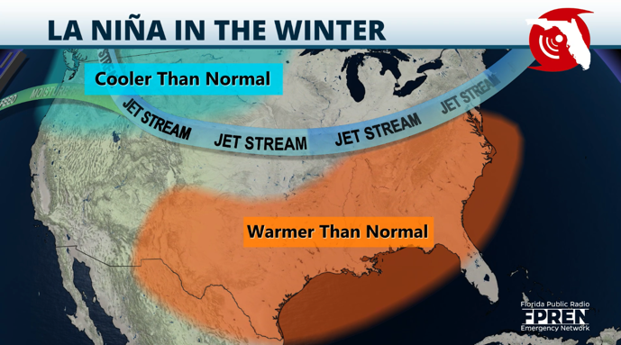
What is La Niña?
El Niño Southern Oscillation, or ENSO, is a phenomenon that occurs in the tropical Pacific Ocean. When average water temperatures are above average, it dictates that an El Niño is present; when temperatures are below average, La Niña is present.

Jacksonville Today thanks our sponsors. Become one.
These phenomena not only bring cooler or warmer-than-average temperatures but also create shifts in the wind shear around the globe and shifts in the position of the jet stream, which bring significant changes in weather patterns while one is present.
La Niña events typically occur every three to five years, but the interval between events can vary from two to seven years.

How does La Niña affect the winter?
La Niña present in the winter months usually displaces the jet stream more northward; this tends to bring drier and warmer than normal conditions during its duration.
There is a 60% chance for La Niña to develop through November, and its chances of developing go up during the winter.
The jet stream’s northward displacement keeps storms moving across northern latitudes and less frequent more south. Fewer storms moving across the South means the weather pattern will stay drier, and with fewer storms that bring clouds, temperatures tend to stay warmer.
Water temperatures also tend to stay warmer than average across the Gulf and eastern Atlantic.


What does it mean for Florida?
When a La Niña is present in winter, the season tends to stay warmer and drier than usual. This pattern was present during the winter of 2016-2017. Late January and February are the coolest months, and 2017 started rather warm.
Many Floridians might remember that the holidays were warmer than usual. There were some slight variations, and cold fronts pushed through, but they were short-lived.
For example, Central Florida’s coldest temperature in January 2017 was 36 degrees. In February 2017, the highest maximum temperature was 87 degrees, and the coldest low was 43 degrees.
In context, the average high temperature for February in Orlando is 72.9 degrees, and the average low is 52.1 degrees. February 2017’s average high temperature was 80.9 degrees, and the average low was 56 degrees. That’s 8 degrees above average for the high and 3.9 degrees above average for the low.
Having La Niña does not mean we will not receive cold snaps. There will be storms and some cold fronts, but they will be less frequent and perhaps less intense. Once the season is over, we will look back and notice the overall trend was warmer than average.
How does this affect wildfires?
Wildfire season in Florida goes year-round, but the peak is usually between April and June. A drier winter might signal more wildfires in the spring and early summer.
La Niña brings drier conditions that coincide with Florida’s dry season. This could exacerbate any drought that develops in the spring and serve as fuel to any wildfires that might spark after winter.
Copyright 2024 Storm Center