Published on September 23, 2024 at 10:01 am
Free local news and info, in your inbox at 6 a.m. M-F. Sign up for the Jacksonville Today newsletter.
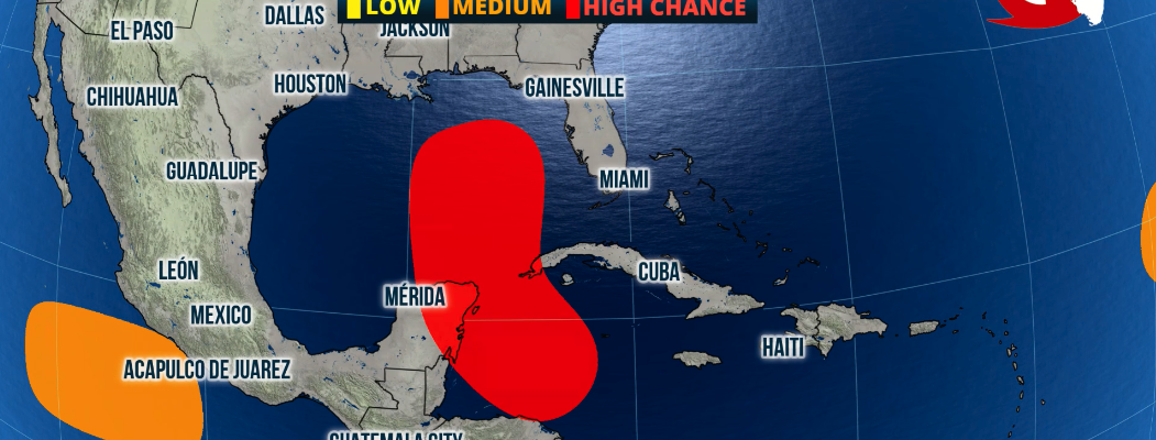
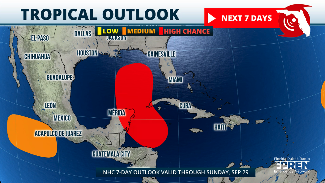
As we start autumn, we are looking at a system that will gradually strengthen over the western Caribbean as it slowly travels northward.
The National Hurricane Center gives it an 80% chance of development in the next seven days and a 50% chance of development during the next two days.
Jacksonville Today thanks our sponsors. Become one.
Now that there is an actual low-pressure system that will bring heavy rounds of rain over parts of Central America we can start to discuss the chances that this system has of affecting Florida.
Remember that the Huricane Center monitors areas where there could be tropical development, but until there is a low pressure models will not grasp the system correctly, therefore any discussion about where a system (that doesn’t exist) would end up is pure speculation.

Now that there is a low, the subsequent model runs will start to grasp this system better, as now there is a center to work with and trajectories improve in certainty. However, we must remember that these are still models and could be deviations.

Jacksonville Today thanks our sponsors. Become one.

What do we know about the tropical system as of Sunday?
In the short term, we are looking at a storm that will bring heavy rains to Central America, Jamaica, the Cayman Islands and western Cuba. For Florida, rounds of rain will arrive as early as Tuesday late afternoon or early evening starting over the keys and moving northward.

The big question remains: How close will it get to the west coast of Florida?
Even though there is good agreement in the early ensemble models that this system will likely make landfall in the northern Gulf Coast somewhere between Mobile and the Big Bend of Florida, a more western track would lessen the impacts to Florida.
If the system keeps a more eastern track, Florida would see more impacts, meaning rain, wind and storm surge.
Rainfall, storm surge and wind forecast will depend on track once this low-pressure becomes a tropical system and goes north. We will monitor it and continue to bring you updates throughout the week.
This is a good time to check your hurricane kit and emergency plans.
The next name on the list is Helene.

Copyright 2024 Storm Center