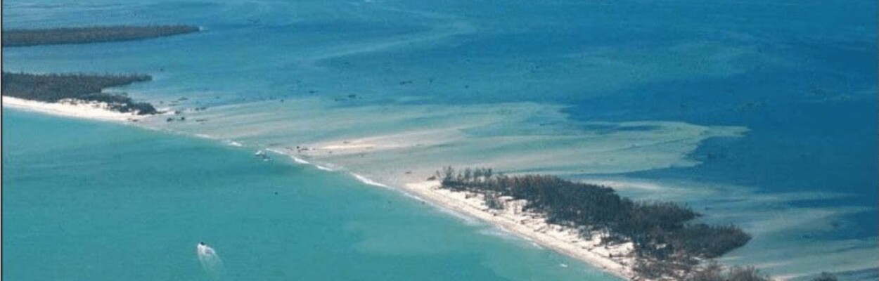
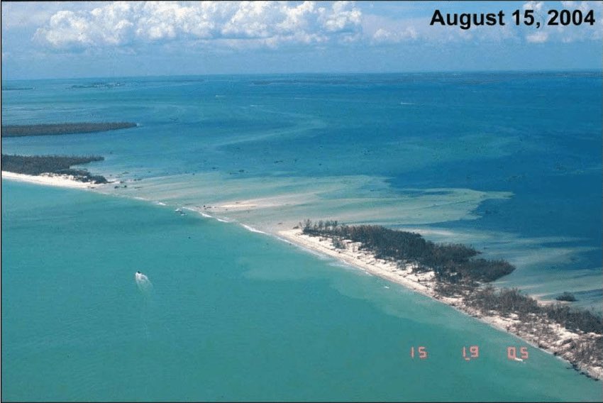
An aerial photograph shows the aftermath of Hurricane Charley.
Published on August 14, 2024 at 9:54 am
Free local news and info, in your inbox at 6 a.m. M-F. Sign up for the Jacksonville Today newsletter.
If you’ve lived in Florida for a good chunk of time, you probably remember this day 20 years ago, especially if you were in the crosshairs of Hurricane Charley that day.
Hurricane Charley was one of five tropical systems that would directly impact Florida over the course of six weeks.
Jacksonville Today thanks our sponsors. Become one.
Charley made landfall as a major Category 4 hurricane with winds near 150 mph near Cayo Costa, just west of Fort Myers, on Aug. 13, 2004. An hour later, the hurricane struck Punta Gorda as a 145 mph hurricane then passed up through Port Charlotte and the Charlotte Harbor. The eye had shrunk before landfall, which limited the most powerful winds to an area within 7 miles of the center.
Charley was a very strong and compact storm and maintained much of its strength as it moved up the state.

Charley’s 150 mph winds and storm surge cut an inlet over a quarter mile wide on North Captiva Island near Cayo Costa, which was later named Charley’s Cut or Charley’s Pass. For many months, the only way to travel back to Florida’s mainland from Captiva Island was by boat.


Jacksonville Today thanks our sponsors. Become one.

Charley was initially expected to hit farther north in Tampa and caught many Floridians off guard due to a sudden change in the storm’s track as it approached the state.
Along its path, Charley caused 10 deaths and $16.9 billion in damage to insured residential property, making it the second costliest hurricane in U.S. history at the time. The very next year, Hurricane Katrina would surpass those damages.

Although Hurricane Charley was forecast to make landfall near Tampa, Punta Gorda, Fort Myers and Charlotte County had been in the National Hurricane Center’s “cone of uncertainty” for four days before landfall. Unexpectedly, Charley turned toward Florida sooner than anticipated, leaving Tampa spared. However, Charlotte, Lee and Sarasota Counties were now in the direct path of the dangerous hurricane.
Charley rapidly intensified before making landfall, which would create a ripple effect across the state. Charley would then move up into the central part of Florida, bringing hurricane force winds, some over 100 mph in the Orlando area.
Widespread power outages and significant damage to the heavily laden tree population in the metro areas of central and southwest Florida left over a million people without power for days, and even weeks.

Charley’s minimum central pressure fell 23 mb from 964 mb to 941 mb in less than 4 hours. This rapid intensification tightened up Charley’s winds and its large hurricane force wind field prompted the majority of Florida to prepare for hurricane force winds while the storm traveled up the State.

In 2004, there wasn’t a way to inform the public of impending high end, catastrophic winds. So the local National Weather Service issued tornado warnings to prepare people for the most extreme approaching winds.
Evolution of the Extreme Wind Warning
Several years later, this led to the development of the Extreme Wind Warning by the National Weather Service. Extreme Wind Warnings are issued when a Category 3 or greater storm is moving over an area and winds are expected to be 115-plus mph within an hour. It’s one of the most severe and dangerous warnings the Weather Service will issue to the public to warn them of imminent danger.
The concept of the Extreme Wind Warnings was developed by the Weather Service’s office in Melbourne, and they were the first to issue one during Hurricane Matthew in 2016.
After Charley moved through the metro Orlando area, it moved north-northeastward and caused significant damage across the Palm Coast area, north of Daytona Beach. Hurricane Ian, which hit Southwest Florida in 2022, was the strongest storm to hit the area since Charley.

By the end of September, four hurricanes slammed into Florida in 2004: Charley, Frances, Ivan and Jeanne. This all happened in less than six weeks. It created more than $50 billion in damage and spawned over 275 tornadoes along the Atlantic seaboard.
It was an unprecedented year for Florida and what historians called a 1 in 100-year hurricane event. There have been many storms and hurricanes that have affected Florida and the southeastern United States since Charley, but for those who lived through and survived Charley, it is one that will stay with them for many years to come.

For an overview of the unprecedented 2004 hurricane season and how it affected millions of people across the eastern United States, click below for a video from the National Weather service in Tampa, FL.
Copyright 2024 Storm Center