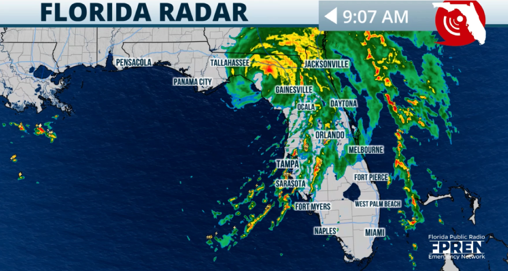
Hurricane Debby came ashore Monday morning in the Big Bend area of Florida and was expected to creep across the state toward Northeast Florida.
The storm hit near Steinhatchee, north of Cedar Key and 70 miles west of Gainesville.
Forecasters said the Category 1 hurricane would weaken to a tropical storm after landfall and could deluge the Jacksonville area with up to 12 inches of rain.
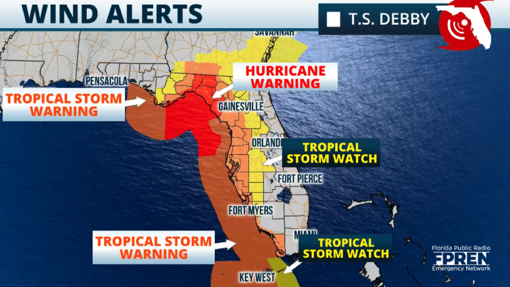
A tropical storm warning was in effect from St. Augustine north into South Carolina. A storm surge warning was issued for southeast Georgia and the South Carolina coast, but it did not include Northeast Florida.
A tropical storm warning means that tropical storm conditions — winds of at least 39 mph — are expected somewhere within the warning area within 36 hours.
Debby was moving north-northeast at near 12 mph at 5 a.m. Monday. Maximum sustained winds were near 80 mph, and hurricane force winds extended up to 25 miles from the center of the storm, the Hurricane Center said. Tropical storm force winds extended 140 miles.
After coming ashore, Debby is forecast to slow down and turn northeastward across northern Florida and southeastern Georgia on Monday and Tuesday.
By noon Monday, Debby will be about 20 miles inland just to the southeast of Tallahassee. This is when conditions will start to get more dangerous. Even with a storm that will be losing its windspeeds as it interacts with land, the heavy rains will fall over the same places, for a prolonged period.
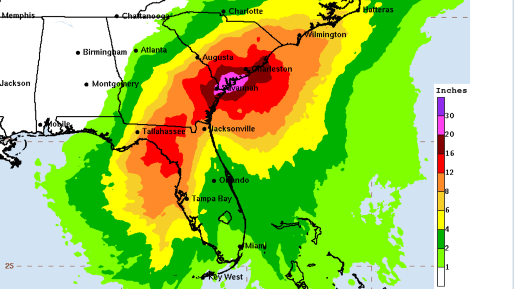
The Hurricane Center said the storm will move about 60 miles in 12 hours. This is when the largest rainfall will fall for North Florida and the eastern portion of the Panhandle. Central Florida can expect to receive up to 8 inches across its northern fringes, while cities like Orlando would stay closer to the 4-inch mark.
A hurricane warning was in effect Sunday for the Big Bend area and tropical storm warnings were present along most of the rest of Florida’s Gulf Coast.
Satellite imagery showed that the core of the system was trying to close, a sign of intensification as the eye wall tried to close off and become symmetric.
A big concern was rapid intensification and how much would occur within the next 12 hours before Debby made landfall.
Local response
Meanwhile, the Duval school district announced it will close schools and offices Monday due to the storm. All on-campus events and athletic practices were canceled. Schools will be in contact with families to provide rescheduling information for any orientations or other events.
All branches of the Jacksonville Public Library also will be closed Monday, as will all senior centers and community centers except the Legends Center, which is being used as a shelter.
Huguenot Memorial Park and Kathryn Abbey Hanna Park will be closed Monday, the city said.
The Duval County Emergency Operations Center was fully activated to coordinate storm preparation and response. The city of Jacksonville said there were no mandatory evacuations ordered in Duval County, but the following emergency shelters opened at 5 p.m. Sunday:
- The Legends Center, 5130 Soutel Drive, open for general population, special medical needs and pet-friendly.
- Landmark Middle, 101 Kernan Blvd., open for general population, special medical needs and pet-friendly.
- LaVilla School of the Arts, 501 N. Davis St., open for general population.
Clay County opened these shelters:
- Keystone Heights Elementary School, 335 S.W. Pecan St.
- Orange Park High School, 2300 Kingsley Ave.
- Lake Asbury Junior High (for people with special needs), 2851 Sandridge Road, Green Cove Springs.
The Duval County Supervisor of Elections delayed the start of early voting to Wednesday.
JEA said it would temporarily suspend customer disconnections for nonpayment as crews mobilized for the storm.
More than 500 crew members were prepared to restore electricity, water and wastewater services as quickly as possible, JEA said. If you lose power during the storm, you can report outages to JEA online or by phone at (904) 665-6000, or text OUT to 69532.
Flash flooding
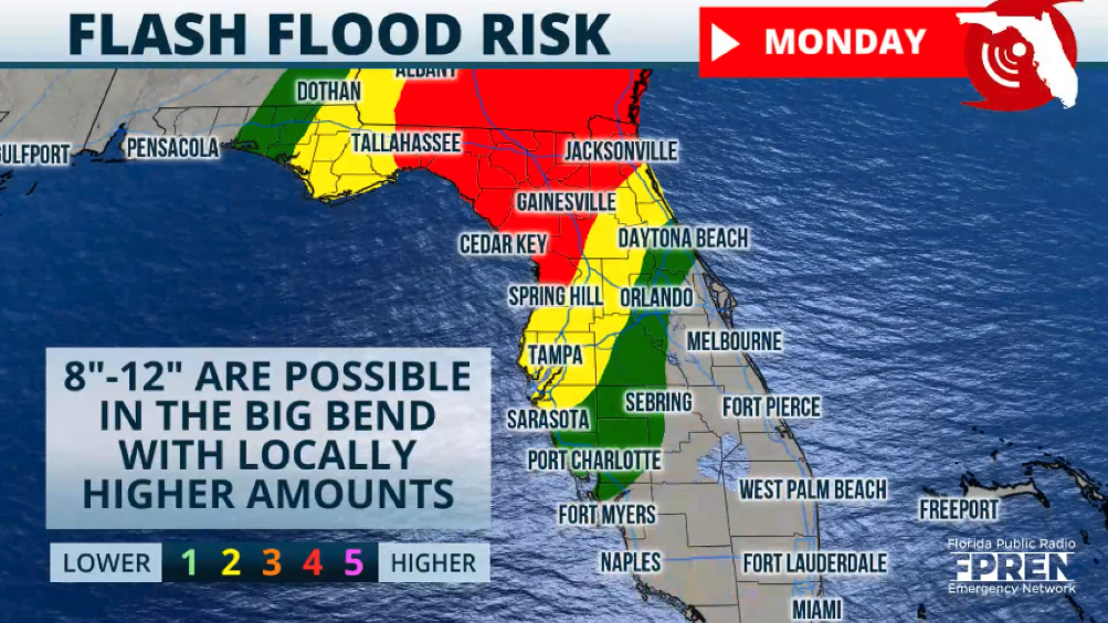
The biggest threat continued to be heavy rainfall across the eastern Panhandle and North Florida. There will be large differences in rainfall from North Florida through Central Florida, with a steep decrease as you move south.
The highest risk for flash floods will be over the Big Bend and North Florida, where some areas could experience up to 12 inches of rain. As Debby inches closer to Florida, expect heavy rain bands to also cross the state and bring the threat for storms to be moving quickly through. Some of the storms could have tornadoes embedded in them.
The biggest threat for tornadoes will be Sunday and through Monday morning from the Fort Myers area to Tampa through central Florida and covering from just east of Tallahassee to Jacksonville.
With the tornado risk, there is also the risk for some thunderstorms to produce gusty winds that can cause damage.
Rainfall in the Jacksonville area will increase Sunday, with conditions deteriorating Sunday night through Monday, according to the National Weather Service in Jacksonville.
The highest risk for flash floods will be focused across North Florida, along Interstate 10 through southern Georgia and the southern South Carolina coast.
Rainfall totals through Thursday show the highest rainfall across the Big Bend area through I-10 to Jacksonville and southeastern Georgia. Central Florida, including the Tampa Bay region, could receive 6 to 8 inches with isolated spots, especially across northern and western Central Florida.
This storm, regardless of intensification, will be a big rain event. Significant winds are forecast across North Florida, but the system is expected to downgrade to a tropical storm once it moves over the state and continues crawling across southern Georgia and South Carolina.
Forward speeds will drop quickly, and it will likely move at about 5 mph or so. The highest risk for flash floods will be over the Big Bend and North Florida.
Debby is a massive storm and the slope of the ocean floor, and the bathymetry over the west coast is not steep. This allows for a large system to push more water inland.
Storm surge will be extremely dangerous across the Big Bend and the rest of the west coast of Florida as the storm continues to intensify and move northward. Two to 4 feet of surge is possible along the west central coast of Florida southward through Bonita Beach. Life-threatening storm surge is possible along the Big Bend region and to the east of where the storm makes landfall.
Information from the Florida Public Radio Emergency Network was used in this report.

Randy comes to Jacksonville from the South Florida Sun-Sentinel, where as metro editor, he led investigative coverage of the Parkland school shooting that won the 2019 Pulitzer Prize for public service. He has spent more than 40 years in reporting and editing positions in Illinois, Iowa, Missouri, Ohio and Florida.


