Published on June 28, 2024 at 9:26 am
Free local news and info, in your inbox at 6 a.m. M-F. Sign up for the Jacksonville Today newsletter.
As it is typical in the month of June Saharan dust takes over much of the tropics. The deep layer of Saharan dust is currently located over the central Caribbean and is suppressing the chances for tropical storm formation in this area. On the periphery of the deeper concentrations of dust there are two tropical waves we are monitoring.
First, let’s talk Saharan Dust.
These fine particles travel in the upper levels of the atmosphere all the way from the Sahara Desert in Africa. Strong winds lift the dust and travel thousands of miles over the Atlantic, often causing big concerns in the western Hemisphere.
Jacksonville Today thanks our sponsors. Become one.
The most affected in the short term are those living in the Caribbean and sometimes along the Gulf States or Southeast (depending on the strength and steering of the winds). People with respiratory issues are the most affected by the dust, especially when concentrations are high.
Dust can also affect the weather. It usually brings drier conditions and very hot temperatures. One could say, hotter than usual for this time of the year, which is already hot enough.

Big deposits of dust fall over the water, and they can bring effects downstream. It exacerbates the growth of toxic algae blooms such as the red tide in Florida in the latter part of the summer or into the fall. But not all is bad. The big and immediate benefit of dust is regarding tropical formation, as this dust and dry air suppresses any tropical activity there could be underneath it.


Jacksonville Today thanks our sponsors. Become one.
Let’s talk tropics
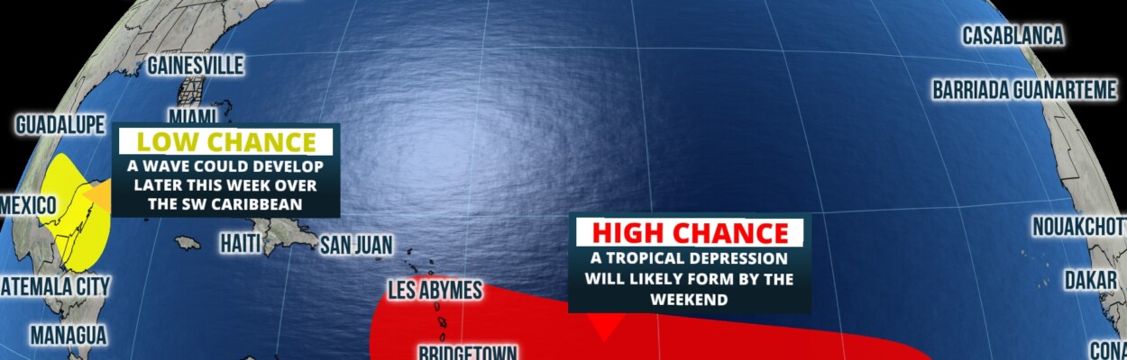
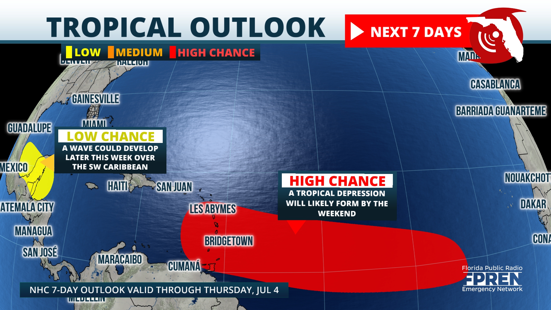
The first tropical wave is Invest 94, located over the western Caribbean. This system continues to battle very dry air as it moves toward the southern Gulf of Mexico. It will have to cross the southern portion of the Yucatan peninsula which will not allow it to develop at least through the beginning of the weekend.
Once it moves over the southern Gulf of Mexico, conditions will become more favorable for this system to develop. At this time the system will be very close to the eastern coast of Mexico. Heavy rains are expected for the same regions affected by tropical storm Alberto.

Invest 95: This one is to watch
The big Caribbean islands and the U.S. should monitor Invest 95L. It’s situated between the Lesser Antilles and the Cabo Verde islands. It is still a long way from the continental United States, but it will move into an area much more favorable for development over the weekend.
The dry air in place combined with the deep Saharan dust will fizzle out and move away from the central Caribbean by the beginning of next week. By then, the tropical wave would have entered the Caribbean.
Wind shear will remain low during the beginning of the week and there is plenty of warm waters over this region. There is plenty of time to monitor this weekend and lots of miles for this system to travel.
It is common during this time of the season for systems to develop closer to the U.S., or around the Caribbean. Invest 95 will be entering this region.
Next week will be an interesting week in the Caribbean. The big questions will be, how far south this system stays, if it develops, and if it makes a turn to the north. If it were to make a northward turn, would it travel over rough and tall terrain?
These are all big unknowns, for now. We will continue to bring you updates are the system travels west and develops.
Copyright 2024 Storm Center