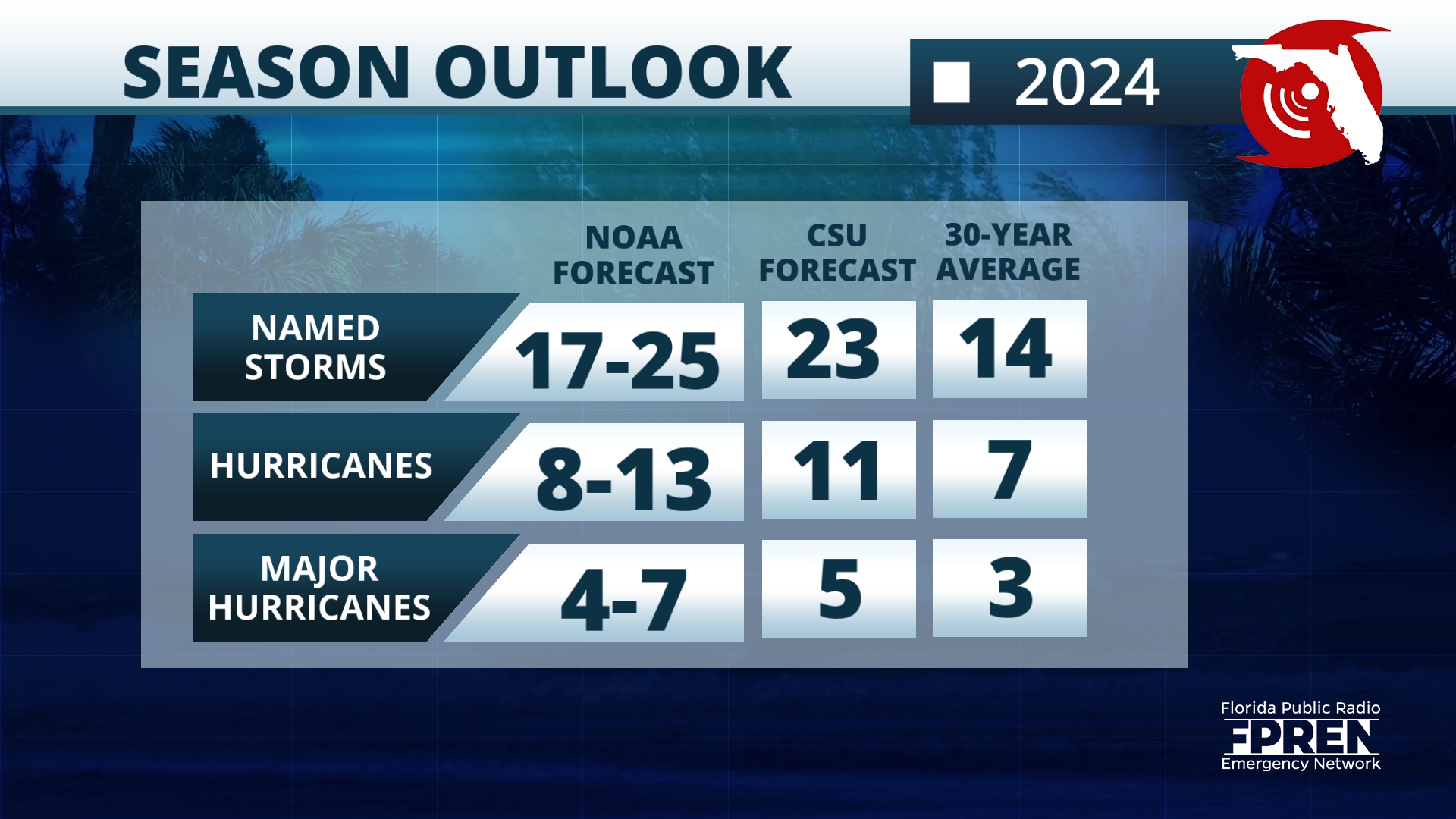
The latest hurricane season forecast is out, this time is the official one issued by the National Hurricane Center. It calls for 17 to 25 named storms, of which eight to 13 could become hurricanes and between four and seven could be major hurricanes, meaning Category 3 and above.
The 2024 Atlantic hurricane season is setting out to be one for the record books. The sea surface temperatures over the main development region are at record warmth for this time of year, and that´s not a good sign. Keep in mind, that ocean water is what fuels storms. The warmer the water, the more fuel available for a storm. But a storm needs more than warm water to form, this is where a special global pattern comes into play — El Niño Southern Oscillation — or its counterpart, La Niña.
El Niño is a pattern that occurs over the tropical Pacific Ocean but has global effects. When El Niño is present, warmer-than-average water temperatures dominate the tropical Pacific, bringing more activity than normal over the Pacific (think warmer temperatures, more tropical activity).
Over the Atlantic, there tends to be more vertical wind shear. Wind shear is the change in speed with height. The stronger the wind shear, the less chance a tropical wave has to continue to develop its structure and gain strength.

The opposite is true when La Niña is present over the Pacific. Therefore, when we have a La Niña during the summer through the fall, there tends to be less wind shear, allowing a storm to continue its structure to form. If there is little wind shear over a low pressure developing, the system has nothing to ‘chop off’ the top layer of its structural growth from there. I we add the fuel (the warm ocean temperatures), then a storm is free to intensify.
There are more ingredients for a tropical system to form, but these are the main ones that signal if a season might be a busy one.

How about the tracks and possible landfalls?
The 2023 Atlantic hurricane season was above average, ending with the fourth most active season on record, with 20 named systems, and the famous major category Hurricane Idalia, which hit Florida’s Big Bend. But zooming out at the entire season, most storms tracked and stayed over the Atlantic Ocean.
This year, this could differ. There is a correlation between La Niña and more western tracks. We did not have a La Niña during the 2023 hurricane season. We can say that the El Niño pattern tends to keep the storms more east, away from the Americas, correlating with what happened in 2023.
It is impossible to know if or how many storms could make landfall at this point. To know this, there needs to be a system, either close to land, or developed with a well-defined center of circulation.

We are monitoring an area of disturbed weather located near the Central Caribbean. It has a low chance of developing within the next seven days, but it will remain well away from the U.S. and enter an unfavorable area for development, therefore its life period seems short.
There are plenty of actions you can take now to prepare for the season ahead.
- Have a plan.
- Know if you live in an evacuation zone.
- Gather important documents.
- Revise your insurance policy ahead of time to make sure you are covered and up-to-date with the latest changes.
For more information about ways you can prepare for the season go to Floridadisaster.gov


