Published on March 21, 2024 at 2:13 pm
Free local news and info, in your inbox at 6 a.m. M-F. Sign up for the Jacksonville Today newsletter.
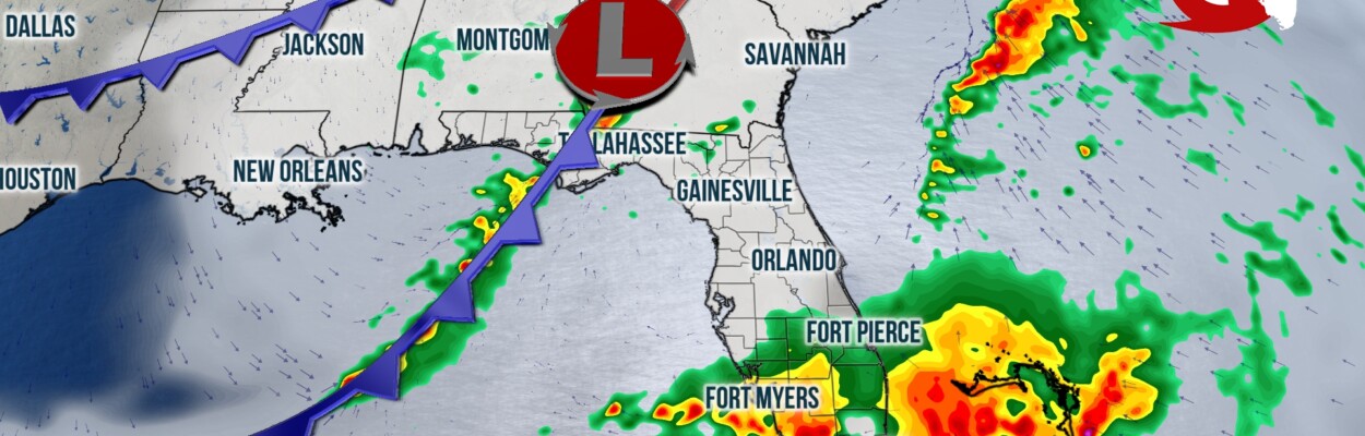
Several rounds of heavy rain and thunderstorms are expected to impact Florida on Friday and Saturday.
Isolated severe thunderstorm cells, and localized flash flooding will be possible, especially across parts of South Florida, where rainfall amounts are forecast to range between 3 and 6 inches.
Jacksonville Today thanks our sponsors. Become one.
Northeast Florida could see 1 to 2 inches of rain.
On Thursday morning, a trough of low pressure was positioned over the western Gulf Coast, near Corpus Christie. Scattered shower and thunderstorm activity was already developing in the vicinity of this feature, from San Antonio eastward to Houston and western Louisiana. Throughout the remainder of the day Thursday, this low is forecast to strengthen as it tracks east-northeastward, paralleling the western and central Gulf Coast.
A warm front should develop southeast of the center of low pressure, and this boundary will likely stretch through the Gulf and approach Florida from the west late Thursday evening into early Friday morning. Along and ahead of the front, a complex of heavy rain and thunderstorms is forecast to develop, and these storms will likely produce periods of heavy rain, gusty winds and a few strong thunderstorms over the southern two-thirds of the peninsula Friday morning.


Jacksonville Today thanks our sponsors. Become one.

Moderate to heavy rain rates are expected to continue through the day Friday and potentially into early Saturday morning across South Florida.
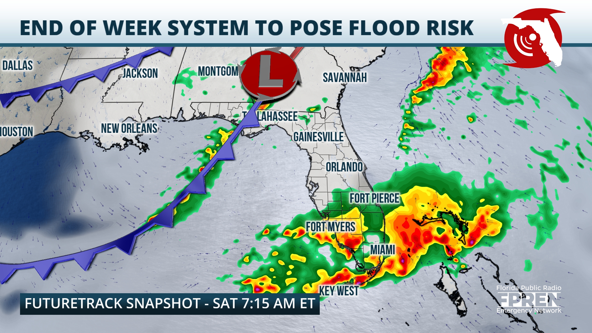
Rainfall totals could reach 3 to 6 inches across Monroe, Collier, Broward and Miami Dade counties. Interests in locations like Naples, Fort Lauderdale, Miami and Key West should prepare for localized flash flooding. In addition, the atmosphere will be supportive of severe thunderstorm development, especially over South Florida and along the immediate Gulf Coast of the peninsula.
Interests in Tampa-St. Petersburg, Fort Myers, Naples , West Palm Beach, Miami and the Keys should remain alert as storms could quickly produce brief waterspouts/tornadoes or damaging straight line winds.
While the warm front aids in shower and thunderstorm development over the peninsula, the core of low pressure should track northeastward from the Central Gulf Coast region inland through Alabama and Georgia. The low will drag a cold front through Florida’s Panhandle during the afternoon and evening hours on Friday, and along this boundary we expect a broken line of thunderstorms to develop.
As with the storms over the peninsula, the cells along the cold front could produce periods of heavy rain rates, gusty winds and tornadoes. While rain is expected for most of the day Friday over the southern half of the peninsula, storms likely won’t become widespread over the Panhandle until the afternoon and evening Friday, lasting through early Saturday morning.
In anticipation of Friday’s system, forecasters at the Weather Prediction Center have outlined most of the Panhandle and South Florida under a Level 1 out of 4 (or “marginal”) risk for flash flooding. The Miami metro area is under a Level 2 out of 4 risk for flooding (or “slight”). In addition, meteorologists at the Storm Prediction Center have included most of Florida’s Gulf Coast and South Florida under a Level 1 out of 5 (or “marginal”) risk for severe thunderstorms Friday.
The cold front from this system should track from the Panhandle through the peninsula during the day Saturday, and another round of strong storms is possible from the Interstate 4 corridor southward. Any additional rainfall could overwhelm the already saturated environment, and localized flooding could become more widespread.
Conditions across the Sunshine State should improve by the latter half of the weekend. By Sunday, skies should be mostly sunny from the Panhandle to the Keys, and highs should range from the upper 60s in the north to the upper 70s in the south.
Copyright 2024 Storm Center. To see more, visit Storm Center.9(MDEwNzczMDA2MDEzNTg3ODA1MTAzZjYxNg004))