Published on September 8, 2023 at 3:31 pm
Free local news and info, in your inbox at 6 a.m. M-F. Sign up for the Jacksonville Today newsletter.
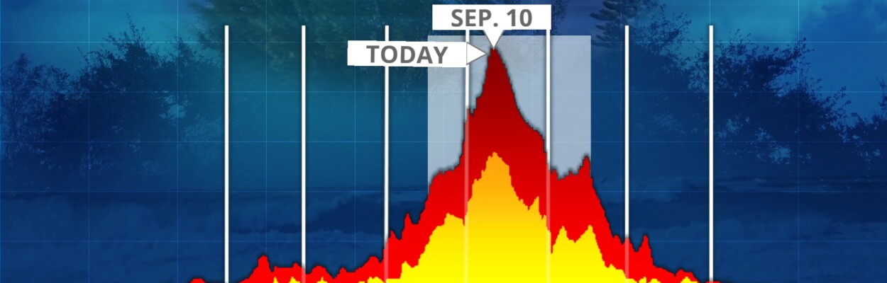
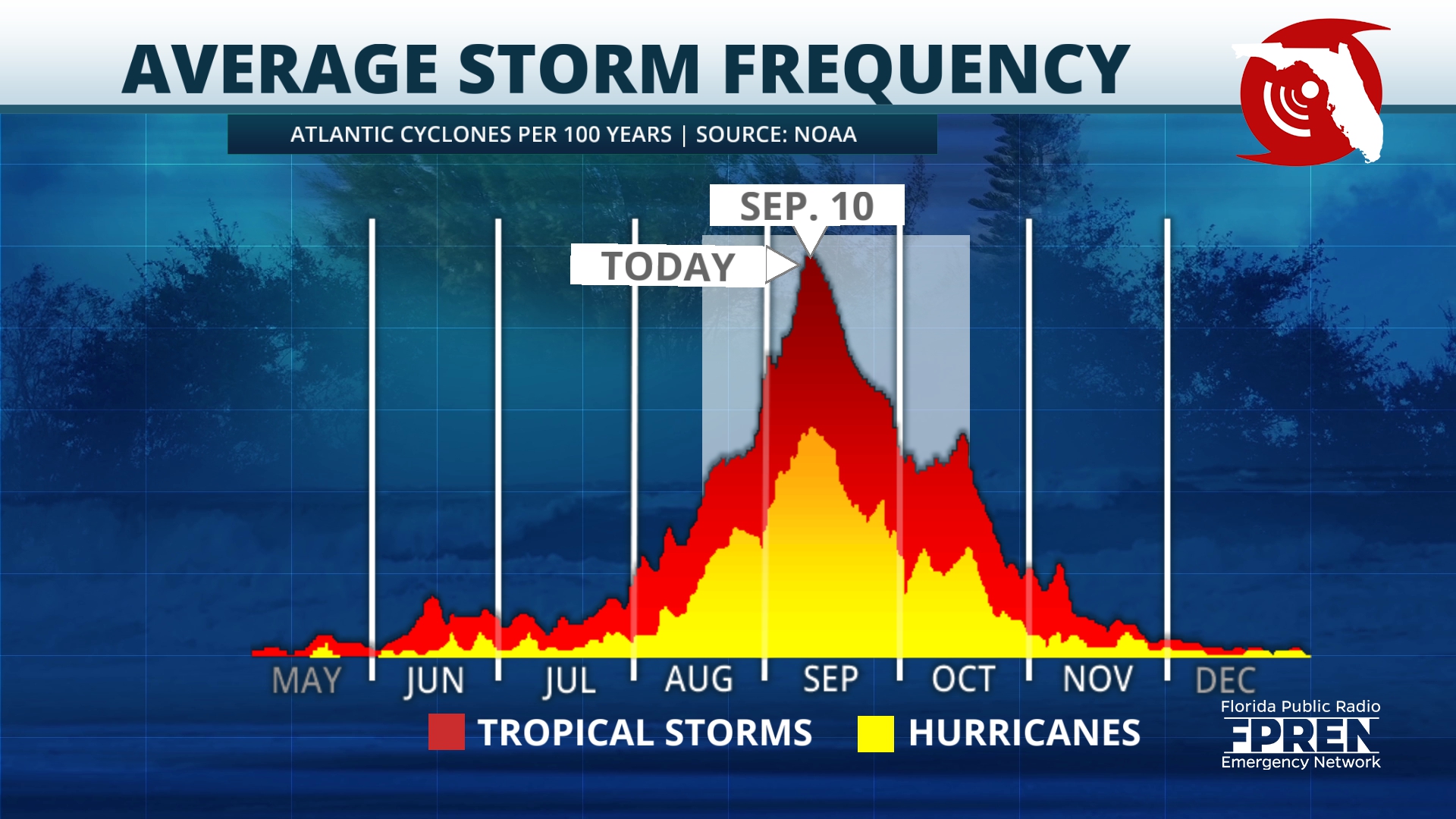
In a typical Atlantic Ocean hurricane season, August through mid-September is the busiest time for tropical storms and hurricanes. This season is no different.
Historically, more than 85% of all major hurricanes (Category 3, 4 and 5) form after Aug. 20, according to the National Hurricane Center.
Jacksonville Today thanks our sponsors. Become one.
Tropical Storm Harold developed in the western Gulf of Mexico on Aug. 22, as the fourth Atlantic named storm to form within 39 hours. This is the fastest time on record for four Atlantic storms to form, breaking an 1893 record.
This season’s third hurricane, Idalia, made landfall in the Big Bend region of Florida last week as a high-end Category 3 and descended on the Carolinas as a tropical storm, leaving behind flooding, wind damage and dangerous rip currents.
Thirteen tropical cyclones, with four being hurricanes, have been named so far. The average season has 14 named storms, seven becoming hurricanes and four major hurricanes.


Jacksonville Today thanks our sponsors. Become one.

Moving forward
NOAA’s weather outlook from August predicted an “above-normal” level of activity.
“The main climate factors expected to influence the 2023 Atlantic hurricane activity are the ongoing El Niño and the warm phase of the Atlantic Multi-Decadal Oscillation, including record-warm Atlantic sea surface temperatures,” Matthew Rosencrans, lead hurricane season forecaster with NOAA’s Climate Prediction Center, said in August. “Considering those factors, the updated outlook calls for more activity, so we urge everyone to prepare now for the continuing season.”

As of this afternoon, Hurricane Lee is about 565 miles east of the northern Leeward Islands, moving west-northwest at 13 mph. Models predict Lee will curve northward, remaining over the open Atlantic, but there is always a possibility for slight changes in the track.
The National Hurricane Center says Lee is expected to remain a powerful hurricane through early next week. Lee was a Category 4 hurricane as of 11 a.m., but fluctuations in intensity are likely over the next few days.

Lee’s wind speeds doubled in 24 hours, peaking at 165 mph last night. It is too soon to know what impacts will be felt in the U.S. Lee is expected to slow down over the southwestern Atlantic.
East of Lee, Tropical Storm Margot formed in the North Atlantic Ocean on Thursday, currently posing no threat to land. Margo is forecasted to reach hurricane strength by the weekend. Sustained winds have reached 40 mph.

Tropical storms with sustained winds of 39 mph receive a name. When winds reach 74 mph, it is considered a hurricane. At 111 mph, disturbances become major hurricanes.
The Atlantic hurricane season runs from June 1 through Nov. 30, so there is room for more storms to form. Stay plugged in this season with the latest updates from Florida Storms app.
Copyright 2023 Storm Center. To see more, visit Storm Center.9(MDEwNzczMDA2MDEzNTg3ODA1MTAzZjYxNg004))