Published on August 29, 2023 at 11:51 am
Free local news and info, in your inbox at 6 a.m. M-F. Sign up for the Jacksonville Today newsletter.
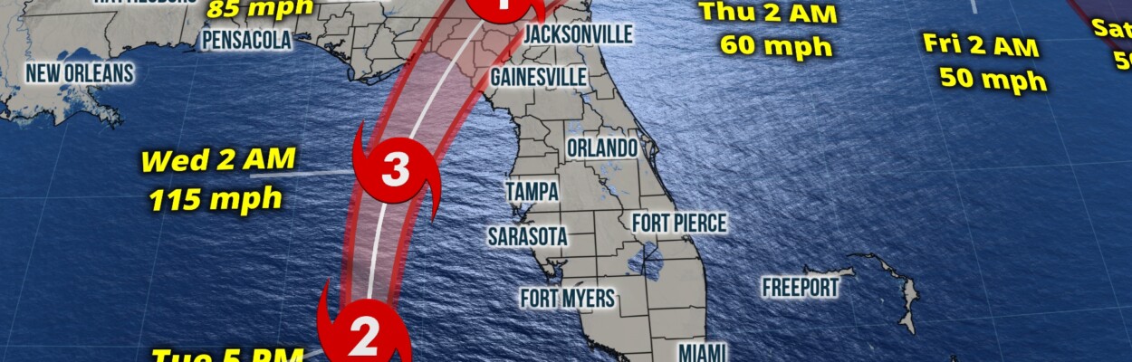
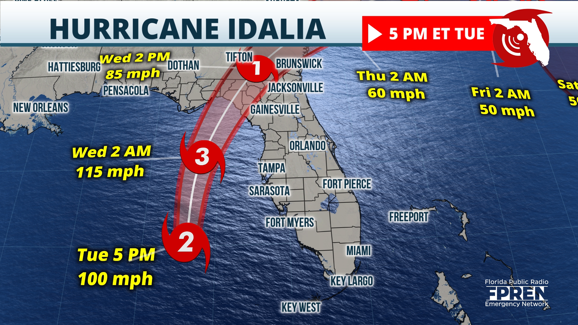
Hurricane Idalia is rapidly intensifying as it bears down on the Gulf Coast of Florida and threatens the First Coast with high winds and potential flooding Wednesday.
The forecast calls for Idalia to strengthen into a major Category 4 hurricane and make landfall early Wednesday somewhere across the Big Bend Coast of Florida. Most models are zeroing in on the area of Apalachee Bay, directly south of Tallahassee, for landfall Wednesday morning, the National Hurricane Center said in an update at 11 p.m.
Jacksonville Today thanks our sponsors. Become one.
Depending on the final track, hurricane-force winds over 100 mph may spread well into the Panhandle and down the west coast. Tropical storm-force winds, at least 39 mph, are expected to arrive in Northeast Florida sometime after midnight. Some forecasts suggest the possibility of a Category 1 hurricane gusts in the Jacksonville area, meaning winds from 74 mph to 95 mph.
The Hurricane Center predicts 1 to 4 inches of rainfall in Greater Jacksonville and a storm surge of 1 to 3 feet along the St. Johns River. A tropical storm warning is in effect for more than 400 miles of eastern U.S. coastline, from Palm Coast to North Charleston, South Carolina.
READ MORE ABOUT IDALIA
The Hurricane Center said Idalia was over an area of extremely warm water and low wind shear, which has allowed the storm to intensify quickly. Idalia will pick up speed through Wednesday morning, the Hurricane Center said.

Jacksonville Today thanks our sponsors. Become one.
Residents were encouraged to have hurricane preparations finished Tuesday by sunset as tropical storm conditions were expected to start hitting parts of the Gulf Coast. Significant impacts will be felt well outside the cone.

The Jacksonville Emergency Operations Center warned Tuesday that the strongest winds and risk of flooding in the Jacksonville area will occur between 11 a.m. and 3 p.m. Wednesday. Isolated tornadoes are possible along with flooding in low-lying neighborhoods along the St. Johns River and the Atlantic Coast. Residents of those areas were encouraged to seek shelter if needed, but no evacuations have been ordered in Jacksonville.
A bus route has been established to take people from the bus stop at Ken Knight Drive and Moncrief Road — a historically flood-prone neighborhood– to the shelter at the Legends Center. The buses will run until conditions deteriorate to the point that it’s no longer safe. JTA will provide transportation back once the storm passes.
Residents are asked to stay out of the water and off the beaches. Lifeguards were pulled from Duval County beaches at 5 p.m. Tuesday.
St. Johns County has issued evacuation orders for people living in low-lying or flood-prone areas and for anyone living in mobile homes of RVs. Clay County gave similar advice Monday.
In Nassau County, an evacuation order was issued for special needs residents who are power-dependent, as well as those living in flood-prone areas or vulnerable structures.
Putnam County recommended evacuation for people who live in mobile homes and older houses or people in low-lying or flood-prone areas along the St. Johns River.
Statewide, 1.6 million people in 22 Gulf Coast counties are under evacuation orders. Here is a list of affected counties: https://www.floridadisaster.org/evacuation-orders/
Life-threatening storm surge will be one of the greatest impacts, and warnings are posted from the Panhandle to the south Peninsula. Across this area, inundations will average 3 to 7 feet to include Tampa/St. Pete. But the Big Bend Coast is much more susceptible and will need to plan for inundations possibly up to 16 feet.

If Idalia makes landfall as a Category 4 hurricane as expected, sustained winds of 111 to 129 mph are likely near the center of circulation along the immediate coastal areas. Idalia is expected to remain a Category 1 or 2 as it tracks across the state Wednesday. That means winds will range from 74 mph to possibly over 100 mph closest to the eyewall. Winds will decrease farther from the center, but strong gusts will likely cause power outages along with tree and structural damage. Isolated tornadoes are also possible in any of the outer rain bands across the state.

Based on Idalia’s current track, areas closest to the path can expect 3 to 7 inches of rain on average, and locally up to 10 or more inches. Areas well inland across the Panhandle and Peninsula could receive 2 to 5 inches of rain with locally higher amounts.
It’s important to remember that most tropical cyclone-related fatalities are due to the high waters caused by flooding and storm surge. Consider the following advice: hide from the wind, run from the water.

Traveling across impacted areas on Wednesday will be dangerous and highly discouraged. Download the Florida Storms app to keep you safe and informed at all times.
Copyright 2023 Storm Center. To see more, visit Storm Center.9(MDEwNzczMDA2MDEzNTg3ODA1MTAzZjYxNg004))