Published on August 1, 2023 at 9:11 pm
Free local news and info, in your inbox at 6 a.m. M-F. Sign up for the Jacksonville Today newsletter.
Now considered part of Downtown Jacksonville, the waterfront district between the St. Johns River and I-95 has a deceptively long history of its own. From a ferry landing to shipyards to skyscrapers, here’s a dive into the story of the ever-changing Southbank.
The King’s Road and the Cow Ford

Today, the Southbank neighborhood is rarely thought of outside the context of the better known Northbank across the river — in fact, its best known attribute is its especially excellent view of the Northbank skyline. But for more than 250 years, the Southbank has had a unique history and an immeasurable impact on the evolution of Jacksonville.
Jacksonville Today thanks our sponsors. Become one.
While both banks of this part of the river saw intermittent use by Native Americans and British and Spanish colonizers long before, what’s now Downtown Jacksonville first saw consistent settlement in the 1760s during Florida’s British period. At this time, this relatively narrow section of river was an established crossing for humans and cattle, known as the Cow Ford by the British and as Waca Pilotiketa (later written by English-speakers Wacca Pilatka) in the Muskogean languages of the Seminole. The British, who had taken Florida from the Spanish in 1763, made the Cow Ford a crossing for the ambitious King’s Road that connected St. Augustine to Georgia. Here the colonial government established a ferry that docked on the south side of the river. As such, the Southbank had permanent habitation well before the Northbank did.

In the British period, a small community grew up around the Cow Ford and much of the surrounding land was developed as plantations that enslaved Africans. One notable visitor of the period was naturalist William Bartram, who bought a sailboat at the Cow Ford in 1774. The British plantations were mostly abandoned when Florida returned to Spanish control in 1783, and the Spanish government encouraged new plantations with land grants. The Spanish also built Fort San Nicolas to guard the ferry crossing; this name survives today in the St. Nicholas neighborhood east of the modern Southbank and San Marco.
At this time, what’s now the Southbank was part of two plantations worked by enslaved people. The western plantation was granted to Ezekial and Elizabeth Hudnall. The eastern land was first granted to William Jones, then to William Hendricks, whose son Isaac moved there. After their spouses died, Isaac Hendricks and Elizabeth Hudnall married, joining their lands.

Jacksonville Today thanks our sponsors. Become one.
South Jacksonville and the working waterfront

After the Civil War, the Hendricks-Hudnall plantation lands were broken up and developed. Former Gov. Harrison Reed purchased the eastern part of the property and developed it as South Jacksonville. Meanwhile, Elizabeth Hudnall Hendricks sold off property east of the Kings Road as the community of Oklahoma. These settlements and others to the south grew together into a single community known as South Jacksonville.
South Jacksonville prospered as a suburb of Jacksonville, especially after the Florida East Coast Railway Bridge connected the Northbank and Southbank in 1890. The area south of St. Johns Avenue, now Prudential Drive, was largely developed for residences and neighborhood-scale commercial buildings, while the waterfront was dominated by maritime and industrial uses served by a rail spur connecting to the FEC main line. Wharves and railroads sprung up where cows had once crossed the St. Johns.
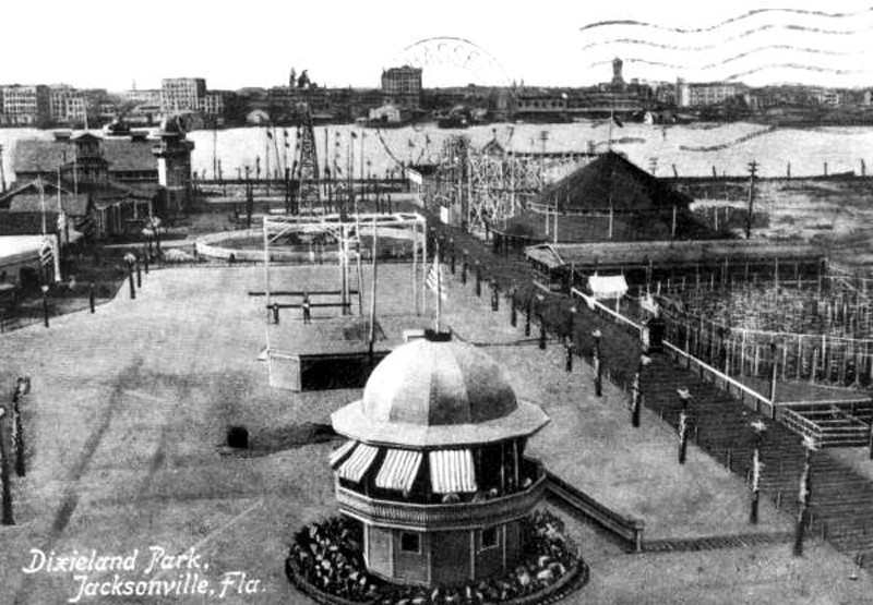
In 1907, the South Jacksonville riverfront became home to a tourist attraction, Dixieland Park. Billed as Florida’s Playground, the 21-acre park boasted a merry-go-round, roller coaster, a Dixieland band, ostrich races and alligator enclosures. Notably, it was home to a local landmark that still survives today, the Treaty Oak. The park lasted only until 1917, at which point it was parceled off and developed.

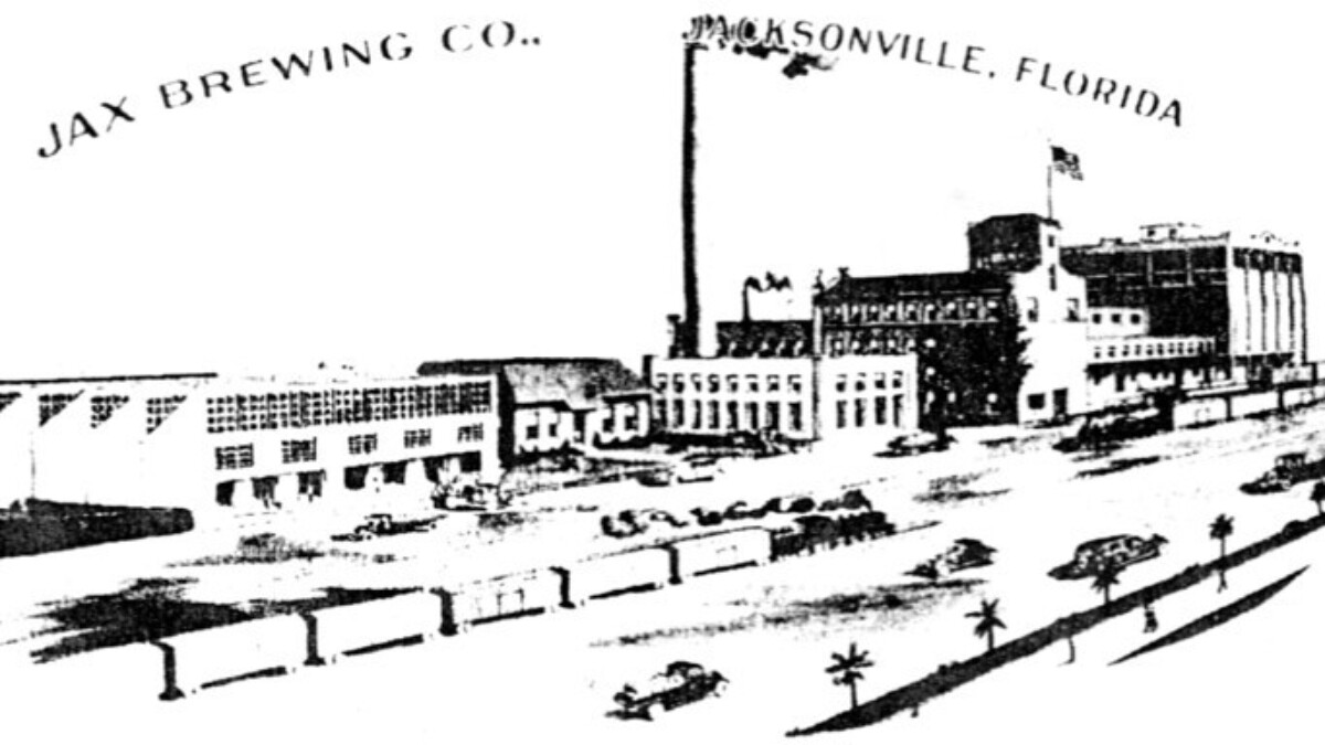
In 1908, George Williams Gibbs founded the Gibbs Corp. Shipyards at the northern end of the Kings Road to build ships featuring a new, more efficient engine he’d invented. The shipyard was a massive success and had a substantial impact on Jacksonville’s development. It grew to encompass most of the Southbank riverfront between what’s now the Main Street Bridge and the Southbank Hotel Jacksonville Riverwalk. In 1924 Gibbs took over the struggling Florida Ferry Co.; he also championed the construction of the Main Street Bridge, which put his ferry out of business but drove additional growth for South Jacksonville.

South Jacksonville voted to be annexed by the city of Jacksonville in 1932. Over time, the former town came to be known by the name of its most prestigious development, San Marco, while the name South Jacksonville or the Southside came to encompass a much larger part of town. The industrial Southbank waterfront was prospering, but it was about to see another round of radical transformation.
Becoming Downtown’s Southbank

The old working waterfront declined by the 1950s, but the Southbank didn’t stay down for long. In 1954, Baptist Hospital opened toward the far western end of the Southbank. Just east of it, the 305-foot Prudential Building opened in 1955, becoming the tallest building in Jacksonville at the time and one of the tallest in Florida.
These structures signaled a change in Southbank’s development pattern that replaced old industrial space with “downtown”-style towers. Unlike the Northbank, which has mostly maintained a traditional urban grid pattern, the Southbank’s towers prioritized automobile traffic and parking. This pattern continued, making the Southbank less walkable and more autocentric than either the Northbank or San Marco.


The retreat of the working waterfront led to additional infill. Through the 1960s, the Southbank saw the construction of Friendship Fountain, the Museum of Science and History, and the Riverplace Tower. When the 432-foot Riverplace Tower opened in 1967, it was the tallest building in Florida other than NASA’s Vehicle Assembly Building on Merritt Island. During the mid-1970s, the Gibbs Shipyard, then owned by Fruehauf Corp., became a casualty of the decline of American shipbuilding. Fruehauf shuttered the old shipyard and consolidated its operations on the Northbank.

The abandoned Gibbs yard became a major focus of redevelopment efforts by Mayor Jake Godbold when he took office in 1978. The Godbold administration labeled the 1980s as “The Billion Dollar Decade” for Downtown redevelopment. By 1982, the former shipyard had been replaced with a riverfront mixed-use development featuring a 322-room Sheraton Hotel and waterfront retail and office complex anchored by two large restaurants, Chart House and Crawdaddy’s. Meanwhile, the Baptist Health system grew dramatically, purchasing and developing much of the western Southbank. With the Southbank changing dramatically, the city of Jacksonville made the district, officially the area between I-95 overpass and the river, part of the official boundaries of Downtown.

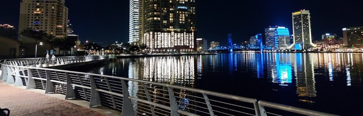
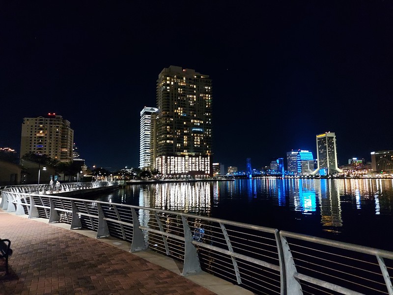
In 1985, the 1.2-mile Southbank Riverwalk was completed, linking the new riverfront hotel, dining and retail complex to Friendship Fountain and the Harbor Masters restaurant west of the Main Street Bridge. Opening to great fanfare, the Southbank Riverwalk didn’t live up to expectations, partially because many of the original amenities proposed were never constructed. Falling into disrepair by the early 20th century, Friendship Fountain and the Southbank Riverwalk were reconstructed by the Alvin Brown administration in 2015. Along with the Northbank Riverwalk, constructed starting in 2000, the Riverwalks have become one of the most popular attractions in the Urban Core and one of the best places to see Jacksonville’s cityscape.


Ongoing plans such as the Riverplace Boulevard road diet, the extension of the Riverwalk, and the Fuller Warren Bridge Shared-Use Path are aimed at better connecting the Southbank not only to the Northbank but to San Marco, Brooklyn and Riverside as well, for both cars and freight trains and also cyclists and pedestrians. These continued changes, appropriate for a neighborhood undergoing a 250-year period of constant evolution, are a sign that the Southbank’s importance to Jacksonville will continue for many years.
Join The Jaxson crew for an evening walking tour of the Southbank’s past, present and future on Thursday, August 3.