Published on August 18, 2025 at 9:59 am
Free local news and info, in your inbox at 6 a.m. M-F. Sign up for the Jacksonville Today newsletter.
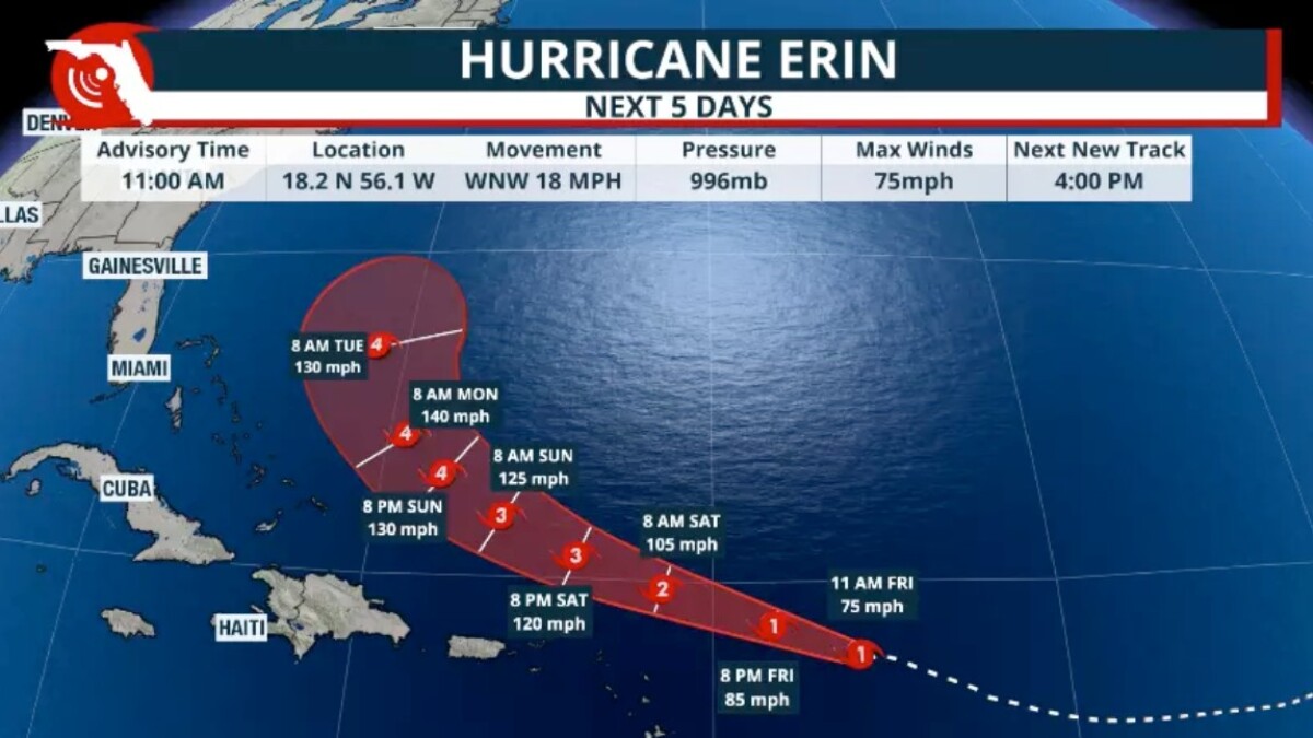
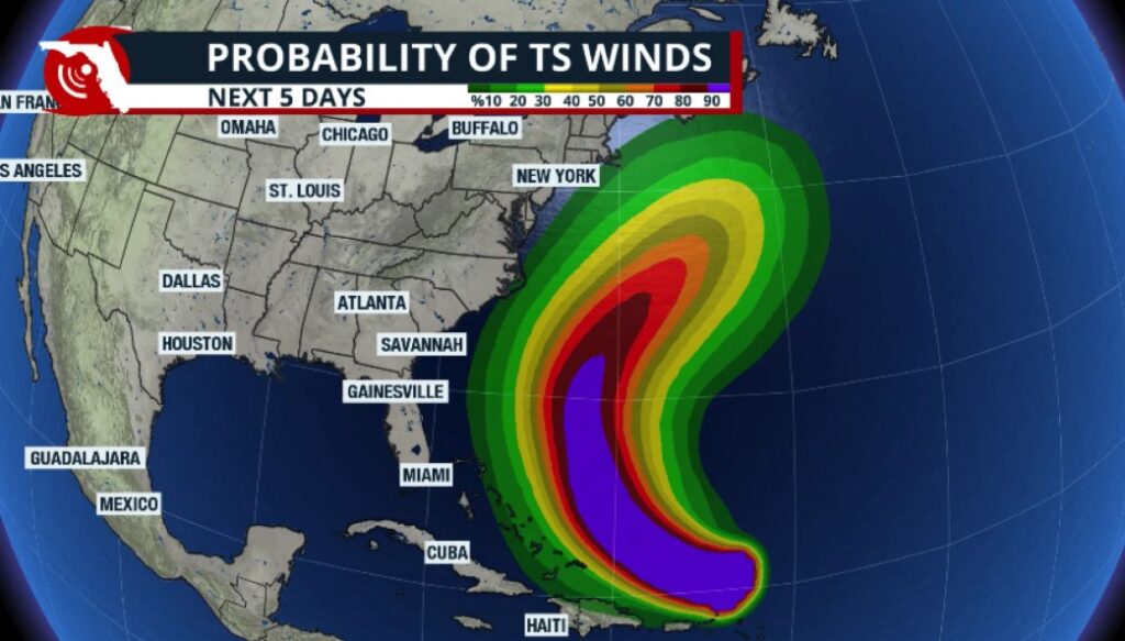
Hurricane Erin is expected to stay away from the Eastern Seaboard of the U.S., but the powerful storm could produce giant waves and rip currents in Northeast Florida.
Erin is expected to remain as a major hurricane, at least Category 3, through the rest of the week. This is a monster of a storm that will expand its windfield as it moves northward over the warm Atlantic waters.
Jacksonville Today thanks our sponsors. Become one.
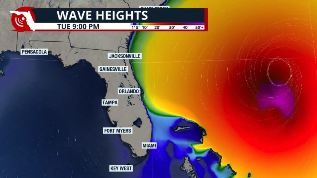
The expansion in the windfield will cause high wave action from much of the east coast of Florida north through the Carolinas and perhaps even through the northeast.
There also be a high risk for rip currents throughout much of the week. Wave heights could exceed 10 feet.
This storm is releasing a lot of energy.
A factor measured in storms is the ”Accumulated Cyclone Energy” or ACE. It is very possible that the accumulated cyclone energy would beat records.


Jacksonville Today thanks our sponsors. Become one.
According to preliminary calculations, Erin’s total ACE could surpass the entire ACE of the 2013 hurricane season — the last season without any major hurricanes.
Rapid intensification
Erin not only rapidly intensified between Friday and Saturday, but also had an extremely rapid intensification.
On Friday morning, Erin was a tropical storm with maximum sustained winds of 70 mph. By 11 a.m. Saturday, the National Hurricane Center indicated that Erin had gained major catastrophic maximum sustained winds of 160 mph. This is an intensification of 85 mph in 24 hours.
Rapid intensification has become more common in the last few decades. Studies have shown that rapid specification is due to having warmer ocean waters.
Warmer ocean waters are one of the many phases of climate change.
Climate Central, a nonprofit climate organization, did a study at the end of 2024 analyzing the 2024 hurricane season. The results showed that warmer water has contributed to stronger storms.
Warmer waters made Helene have maximum sustained winds 10 mph stronger than they would have been if there were no climate change. Similar trends were found with hurricane Beryl and hurricane Milton.
We know that hurricane categories are solely focused on the maximum sustained winds. A warming climate not only brings warmer ocean waters, but with warmer ocean waters, there’s more evaporation, which is released into the atmosphere and held above until it has only one way to go: down as rain.
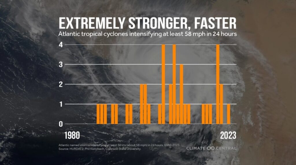
Focusing solely on rapid intensification as it is scientifically and meteorologically described, a storm must intensify by 35 mph during 24 hours to be considered rapid intensification. But a rapid extreme intensification is defined as a storm that intensifies at least 58 mph during 24 hours.
The trend shows that rapid extreme intensification is becoming more common this century, with over a dozen storms that have intensified at least 58 mph in a day, in recent decades.