Published on August 14, 2025 at 10:05 am
Free local news and info, in your inbox at 6 a.m. M-F. Sign up for the Jacksonville Today newsletter.
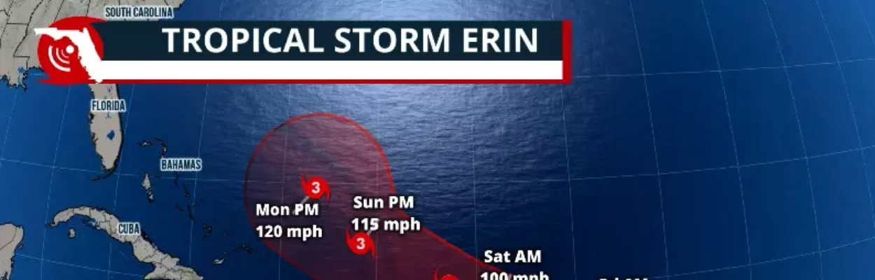
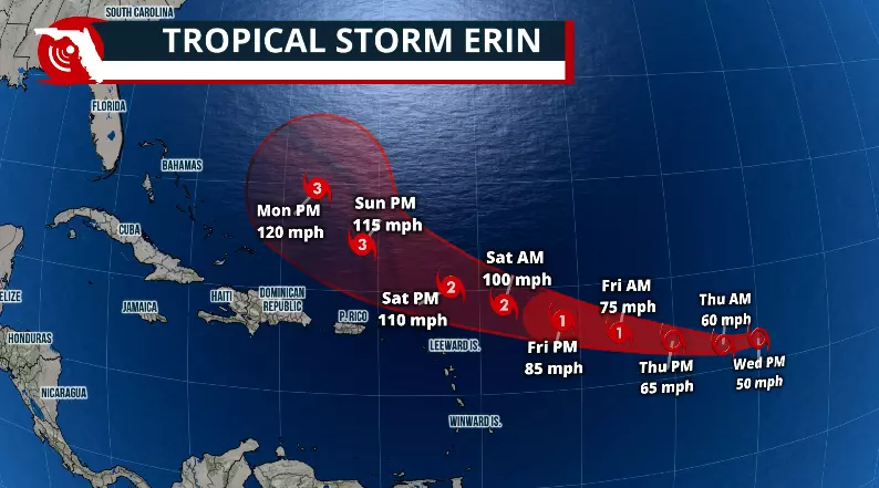
Tropical Storm Erin is over 1,400 miles east of the Lesser Antilles, moving mainly to the west at about 17 mph. It is expected to continue with this track through the weekend.
Most models continue to show that the system will stay north of the eastern Caribbean. Still, if you’re heading down to the Caribbean, expect stormy periods as Erin’s rain bands will sweep through the smaller island chains. Gusty winds and rough seas will be the most dangerous impact from the system.
Jacksonville Today thanks our sponsors. Become one.
There’s also a risk for rip currents throughout the weekend across the eastern Caribbean.
The high-pressure system is moving Erin westward, and as it moves off a pocket of cooler water, it starts to enter warmer ocean waters, which will allow the system to become stronger.
Erin is expected to become a hurricane Thursday and likely a major hurricane by Saturday night or early Sunday.


Jacksonville Today thanks our sponsors. Become one.

Will Erin turn?
The good news is that Erin is strengthening during the rest of the week. This is usually not the kind of news that we wish for, but in this case, we want the system to become stronger as the odds of turning northward become greater.
A weaker system would make it harder for the high-pressure system to continue guiding the system northward. Still, in this case, Erin is expected to gain major category status, which means that we will be a powerful system, allowing this northern turn.
Over the weekend, we forecast Erin to be turning especially late on Sunday or early Monday morning, and be well over 700 miles east of Miami.

This will be a system that is expected to reach major category, meaning at least a Category 3 hurricane as it makes that shift northward and possibly passes near Bermuda.
A Category 3 hurricane carries winds of 111 to 129 mph.
Considering it will be a major hurricane with very strong winds staying offshore, the seas will become very agitated. Therefore, we expect large swells along the east seaboard from the east coast of Florida through pretty much the Northeast.
Beach conditions will begin to deteriorate early next week, and the seas are likely to remain unsafe for boaters or swimmers through much of the following workweek.