A winter storm is expected to bring historic amounts of snow and other winter precipitation across the Gulf Coast states and possibly even along the immediate coast.
Snow is forecast across the Florida Panhandle from Pensacola to Jacksonville and Gainesville. Snowfall will vary, but it will be a rare sighting in areas not used to snow.
The last time Pensacola had measurable snow was in 2014. Tallahassee had a mix of winter precipitation in 2018, which included quantifiable snow.
The biggest winter precipitation impacts will be across the Panhandle through North Florida, while Central and South Florida will have a stretch of cloudy and rainy days.
A low-pressure system is currently brewing along the western Gulf of Mexico. Frozen air is being pulled in from the north, mixing with moisture from the Gulf. This is a perfect combination for winter precipitation to affect areas from the central Texas coastline through the Panhandle of Florida.
Winter weather alerts
Winter weather alerts are in effect throughout the Florida panhandle, including parts of North Florida.
The extreme western portion of the Panhandle, which includes the Pensacola region, is under a winter storm warning. Snow accumulation between 1 and 3 inches is possible between Tuesday morning and Wednesday morning.
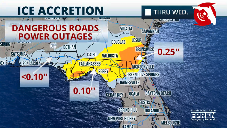
The central portion of the Panhandle, including Tallahassee through the Big Bend, is under a winter storm watch, which means that this could be upgraded to a winter storm warning later Monday as there could be up to 1.5 inches of snow and ice accumulations of up to a quarter of an inch.

Roads, bridges, and overpasses will be dangerously slippery. There will be strong gusts that, in combination with the ice and snow, will weigh heavy on trees, making them fall.
Power lines are also at risk as ice accumulates, and trees could fall on these.
Avoid being on the roads between Tuesday and Wednesday afternoon. It is possible that the temperatures will not rise enough on Wednesday afternoon to melt the snow and ice, therefore stay indoors.
By Thursday afternoon, the skies will clear, and the temperatures will rise to the upper 40s along the Panhandle and North Florida.
This storm will continue to affect the Carolinas with winter precipitation. The front will swing through the state, producing showers across Central and South Florida.
On Wednesday, Central Florida will have highs between the upper 50s and low 60s, with gusty winds that will make the temperatures feel colder. It will be even colder on Thursday, with highs in the 50s.
The clouds will remain through Thursday, and more sunshine will be in the forest for Friday across Central Florida. Saturday morning will be cold, with lows in the mid-to-upper 30s, which could produce some frost, especially across less populated areas.
The coldest air will stay bottled up across the northern half of Florida and slowly arrive in South Florida on Thursday when the highs are expected to remain in the 60s.
It will be a primarily gloomy and cloudy week until Thursday night when fewer clouds will be in place. There will be a few more breaks in the clouds on Friday, with more sunshine returning on the weekend.
The coldest day for South Florida will be on Friday, with highs in the low 60s, and a frigid Saturday morning, with lows in the upper 40s to low 50s. Wind will be gusty on Friday, which will make the temperatures feel colder.


