UPDATED 2:08 P.M.
Tropical Storm Sara formed Thursday afternoon in the Caribbean.
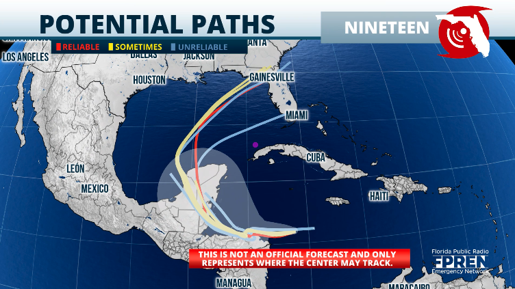
The National Hurricane Center says Sara will be a slow-moving storm from Thursday through the weekend, remaining in the same general area in the western Caribbean.
Torrential rains are forecast for northern Honduras, where some areas could receive over 20 inches of rain. The storm is forecast to possibly reach hurricane status just before Monday’s landfall in Belize or the Quintana Roo state of Mexico.
Although its speed is expected to remain very slow, whatever emerges over the Gulf of Mexico will swing much faster to the north and then to the east-northeast next week.
What does Sara mean for Florida?
First, Florida must monitor a cold front moving over the state on Friday. This is the second cold front of the week and promises to bring a stronger punch of cooler and drier air.
We are not talking about thick coats; the drier air will make it much cooler. Lows over the weekend across South Florida will be in the upper 60s. Central Florida will have lows in the low to mid-60s, and northern Florida could have lows as cold as the upper 40s.

We must closely monitor what will happen to Sara as it meanders over the western Caribbean. It is too soon to discuss any impacts that Florida could experience since this system, apart from moving slowly, will also have to move over the thick Yucatan Peninsula.
This system could emerge over the Gulf of Mexico battered. If this happens, it will struggle to take shape again as the wind shear could increase.
Of course, its moisture is slated to swing toward the east next week, so we can expect it to arrive in Florida, but the great unknown is exactly how much and where.
Keep in mind that although water temps across parts of the Gulf of Mexico are still warm, there will be increasing wind shear, and the temperatures are cooling fast and can´t sustain tropical storm formation as it moves closer to the coast due to rapid cooling.
Take the time to enjoy the weekend and the cooler weather. Be cautious if you are going boating, as the seas will be increasing and could be dangerous for boaters and swimmers.


