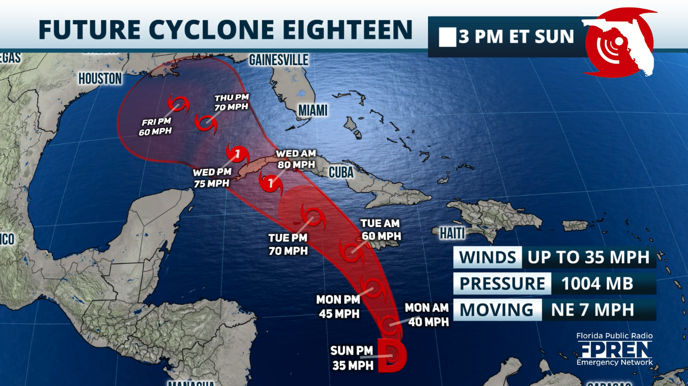
The National Hurricane Center has labeled the disorganized system over the Caribbean as Tropical Depression 18, and it could become a hurricane within a couple days.
This is the same area we have been monitoring for several days, and Hurricane Hunters are currently investigating it. This system has a high chance of becoming the next named system of the season. Rafael is the next name on the list.
In the short term, the Central Caribbean islands can expect torrential rains early in the week as this system moves mainly to the north. Jamaica, the Cayman Islands, central Cuba and eventually eastern Cuba will have direct impacts from this system.
The Hurricane Center’s first advisory signals that this system will become a tropical storm by early Monday. Sea surface waters in this region of the Caribbeans are still warm and can sustain tropical development. Wind shear must also remain relatively low, which could make this (eventual) tropical storm stronger.
The official track by the National Hurricane Center shows the storm gaining hurricane status by Wednesday as it approaches eastern Cuba and emerging over to the Gulf of Mexico by Wednesday night as a Category 1 hurricane.
Of course, it will depend on how much land interaction this system has. The more land friction, the more dented it will move over the Gulf.

The high-pressure system will likely break and open up a channel for this system to continue moving north. Remember that this is the inflection point we will be closely watching wherever the high-pressure system (the same one that has brought us fairly nice weather the last few days) will move east and break, opening up a path for this system to move northward.
The American model, the GFS, shows this weather system intensifying to a strong tropical system or Category 1 hurricane as it approaches Cienfuegos and Matanzas in Central Cuba.
The European model moves this system slower between Sunday and Wednesday. A tropical storm is passing just east of the Isla de la Juventud by late Tuesday. It shows the system merging over the eastern Gulf of Mexico and staying there for a couple of days between Wednesday and Friday.

After Friday, the Euro shows the system slowly crawling to the west. At the same time, the American GFS model has this system in between Louisiana and Mississippi late Friday or Saturday morning as a tropical storm.
Remember that the water near the immediate coast and a bit further out has been cooler in the last few weeks, so water temperatures would greatly weaken any storm as it approaches any coast along the Gulf.
There is the chance that another weak tropical system could follow, traveling just north of the Caribbean and likely increasing the moisture over Florida for next weekend. It is too far to pinpoint if any system would directly impact Florida, but we will continue monitoring closely.
This coming week, you can expect an increase in moisture, translating to more rain and storm activity across much of Florida. The winds will shift, mainly from the south-southeast, bringing in deep tropical moisture moving from south to north along the Peninsula.
Warmer temperatures are also expected, with high heat indices.


