Published on October 6, 2024 at 8:35 am
Find everything you need to make informed decisions this election season, plus so much more. Sign up for the Jacksonville Today newsletter.
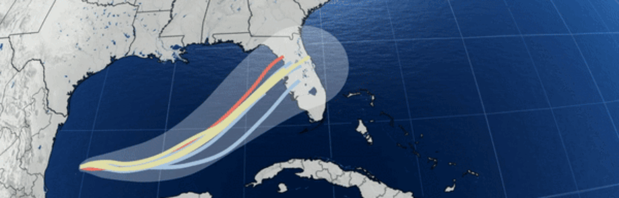
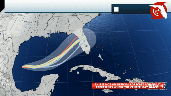
Tropical Storm Milton formed in the Gulf of Mexico on Saturday, and the National Hurricane Center expects the storm to rapidly intensify into a major hurricane before impacting hurricane-weary Florida next week.
Milton is expected to make landfall Tuesday or Wednesday and then cross the state bringing widespread impacts to the west coast of Florida first, and then to parts of eastern Florida.
Jacksonville Today thanks our sponsors. Become one.
This tropical development comes less than two weeks after Hurricane Helene caused devastating damage over parts of the Southeast and Mid Atlantic.
Milton is expected to have maximum sustained winds near 120 mph and then perhaps weaken slightly to a Category 2 hurricane at the time of landfall along the Gulf coast of Florida — near the Tampa/St. area.
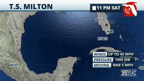
Milton was about 860 miles west-southwest of Tampa at 8 a.m. Sunday. Maximum sustained winds had grown to 60 mph


Jacksonville Today thanks our sponsors. Become one.
Key messages about Milton
1. Milton is forecast to quickly intensify while it moves eastward to northeastward across the Gulf of Mexico and be at or near major hurricane strength when it reaches the west coast of the Florida peninsula mid week. Hurricane Watches could be issued as early as late Sunday for portions of Florida.
2. There is an increasing risk of life-threatening storm surge and wind impacts for portions of the west coast of Florida beginning late Tuesday or Wednesday. Residents in these areas should ensure they have their hurricane plan in place, follow any advice given by local officials, and check back for updates to the forecast.
3. Areas of heavy rainfall will impact portions of Florida on Sunday and Monday well ahead of Milton, with heavy rainfall more directly related to the system expected later on Tuesday through Wednesday night. This rainfall brings the risk of flash, urban and areal flooding, along with minor to moderate river flooding.
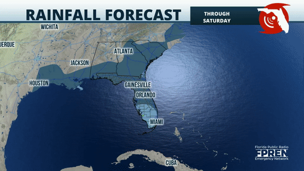
The preliminary rainfall forecast through Saturday is between 4 and 8 inches for locations along and south of Interstate 4 and for the immediate Atlantic Coast.
Six to 8 inches inches of rain is expected in the Jacksonville area, with higher amounts along the coast.
The forecast for exact totals will likely change over the next few days, but the overall theme will remain consistent: Heavy rainfall for parts of the peninsula will pose a mounting threat for flash flooding next week.
No evacuations have been ordered yet, but state officials say those could come as early as late Sunday or Monday if it becomes necessary.
Hurricane and storm surge watches will likely be required for portions of Florida late Sunday, the Hurricane Center said.
Forecasters expect at least blustery onshore winds in Northeast Florida strengthening Tuesday into Wednesday, according to the National Weather Service in Jacksonville. Deteriorating coastal and marine conditions and tidal flooding are expected, especially within the St. Johns River basin.
The amount of rain will depend on exactly where the storm crosses Florida, the Weather Service said.
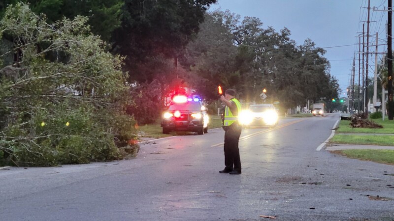
Already weakened trees and limbs from Helene could lead to additional tree damage, the forecast says.
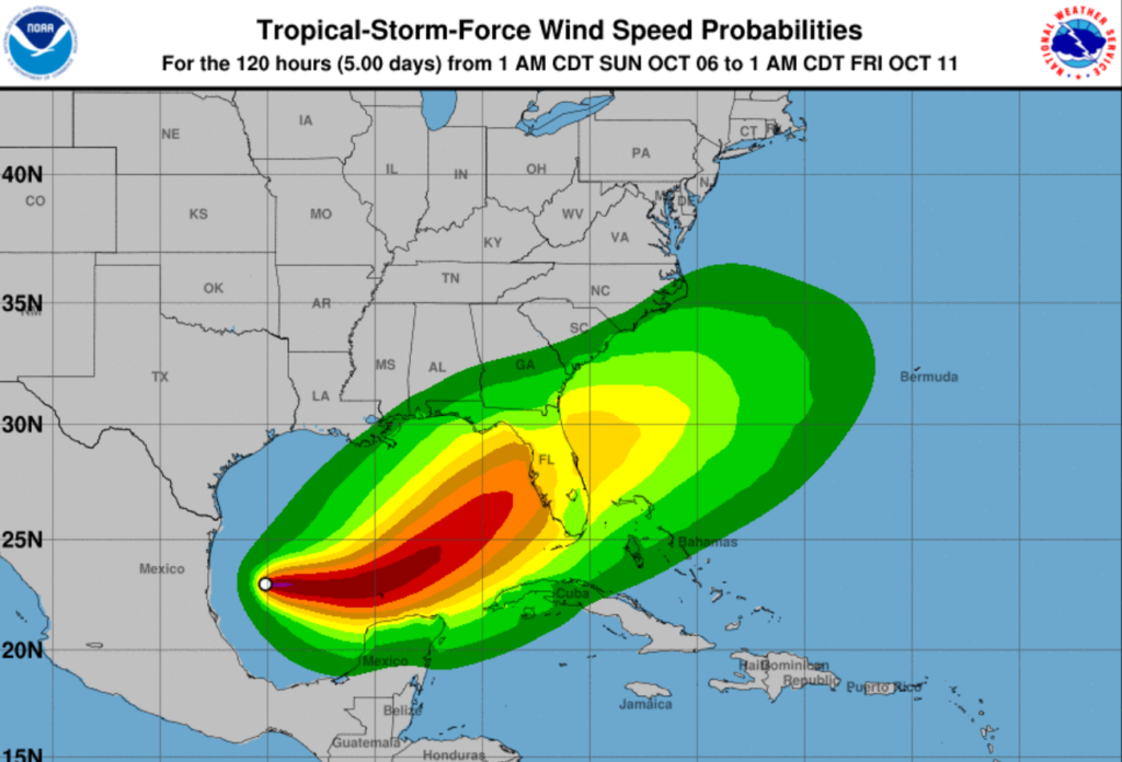
The Jacksonville area has a 20 to 40% chance of experiencing tropical storm-force winds, meaning at least 39 mph, the National Hurricane Center says.
Copyright 2024 Storm Center