Published on October 9, 2024 at 5:08 pm
Free local news and info, in your inbox at 6 a.m. M-F. Sign up for the Jacksonville Today newsletter.
Note: This story is no longer being updated. For the latest on Hurricane Milton’s impacts on the Jacksonville area, return to our homepage.
Although Hurricane Milton is growing, the storm could have a less disastrous effect on Jacksonville than earlier feared, the mayor says.
Jacksonville Today thanks our sponsors. Become one.
Damaging wind and rain are still possible on the First Coast from Wednesday night into Thursday, but Mayor Donna Deegan said projections are less dire than it appeared earlier.
Winds should kick up from 30 to 50 mph at the Beaches and along the Intracoastal Waterway, with some gusts up to 60 mph, Deegan said during a news conference Wednesday.
Inland, winds could be 25 to 40 mph, with gusts up to 50. And rainfall could be lighter than anticipated — 1 to 4 inches with some locally heavier amounts, she said.


Jacksonville Today thanks our sponsors. Become one.
“This is better news … but that’s really what we are looking at, which is much better than if you remember our projections a few days ago,” Deegan said. “So we are grateful for that because that is an area of big concerns for us when it came to flooding.”
Growing Milton
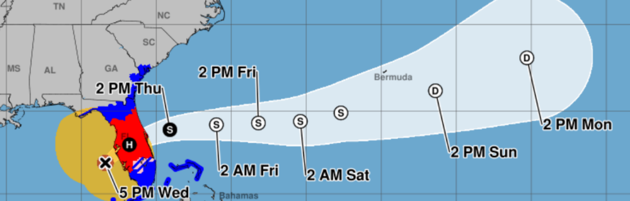
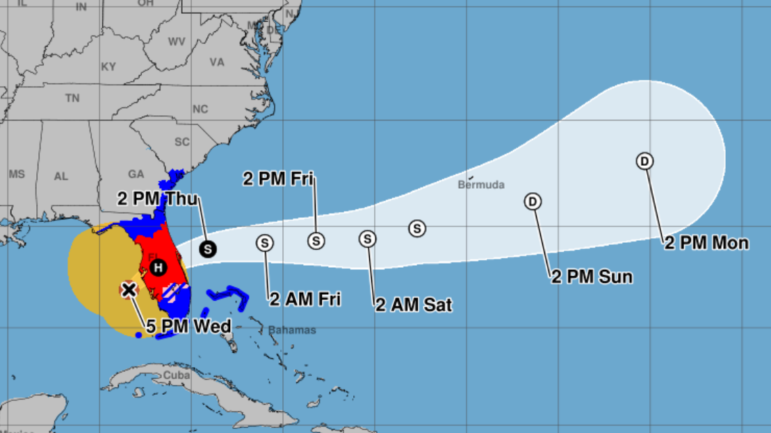
Milton’s winds were declining Wednesday but the size of the hurricane was growing.
Maximum sustained winds had declined to 120 mph as of 5 p.m. Wednesday, the National Hurricane Center said. Hurricane-force winds extended outward up to 35 miles from the center and tropical storm winds up to 255 miles.
Milton was about 60 miles west-southwest of Sarasota at 5 p.m., moving at 17 mph.
Winds decreased as dry air seeped into the circulation, making Milton a Category 3 hurricane, the Hurricane Center said. Continued weakening is expected, and Milton is likely to be right near the threshold of a major hurricane when it makes landfall Wednesday night near Tampa Bay or just south.
The storm will likely remain at hurricane strength as it crosses the state to the East Coast on Thursday.
At 5 p.m., the potential track showed Milton passing into the Atlantic Ocean around the Space Coast. But forecasters warned that projections can be off by 20 or 30 miles with the storm’s arrival still hours away.
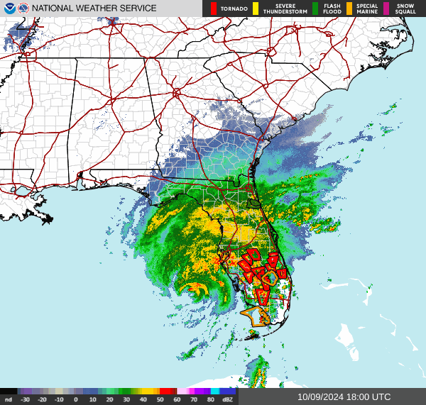
The latest National Weather Service forecast for Jacksonville predicts widespread downed trees and powerlines, with damage to structures and mobile homes.
The highest chance for flash flooding will be across St. Johns, Flagler and Putnam counties. Putnam County already reports that the underpass on Crill Avenue in Palatka was closed at noon Wednesday due to flooding.
As of 4 p.m., the National Weather Service in Jacksonville still predicted winds of 58 to 73 mph in Jacksonville and south into St. Johns County from Wednesday night through Thursday.
Milton was expected to bring 2 to 3 inches of rain to Jacksonville, 4 to 6 inches to St. Augustine, and 6 to 8 inches to Palm Coast, the Weather Service said.
A hurricane warning remained in effect Wednesday from St. Lucie County north to Ponte Vedra Beach. The rest of Northeast Florida remained under a hurricane watch and a tropical storm warning.
See the latest forecast here.
Jacksonville
Deegan advised people to expect river flooding during high tides throughout the weekend and next week in parts of San Marco, Ortega, Riverside, the Southampton and St. Nicholas area of the Southside, as well as the Ribault, Trout and Moncrief waterway area.
The city expects 2 to 4 feet of storm surge at the Beaches and along the Intracoastal Waterway near Butler Boulevard.
“There may be some isolated areas that got a little above that, but we are really feeling good about that 2 to 4 feet probably being as bad as it is going to get in most places,” Deegan said.
The city has not ordered evacuations, but residents in manufactured homes, older homes and low-lying areas, especially with a heavy tree canopy, are encouraged to find a safer location or shelter.
More than 380 people were already in six city shelters as of noon, Deegan said. If any shelter gets to 75% capacity, another of five extra shelters could open to help.
Deegan said shelters are open to anyone fleeing the hurricane elsewhere in the state.
The following shelters opened at 8 a.m. Wednesday:
- Atlantic Coast High School, 9735 R. G. Skinner Parkway, open for special medical needs, pet-friendly.
- Chaffee Trail Elementary, 11400 Sam Caruso Way,) open for general population.
- The Legends Center, 5130 Soutel Drive, open for general population and special medical needs, and pet-friendly.
- Landmark Middle, 101 Kernan Blvd., open for general population, pet-friendly.
- LaVilla School of the Arts, 501 N. Davis St., open for general population.
- Arlington Middle School, 8141 Lone Star Road, open for general population.
Schools: Duval County Public Schools are closed from Wednesday through Friday.
Parking: The following city-owned garages are open Downtown from Wednesday through Friday at no charge:
- Water Street, 541 Water Street.
- Ed Ball Building, 238 W. Monroe St.
- Yates Building, 200 E. Adams St.
- Duval Street, 33 W. Duval St.
JTA also will also open its Kings Avenue Garage, at 1201 Kings Ave., for free.
JTA: JTA will continue regular operations Wednesday and Thursday as long as it is safe. The last trip for the St. johns River Ferry will be at 10:45 a.m. Tuesday. As in the past, JTA will offer free rides to the city’s six shelters. It also will operate a shuttle from flood-prone Ken Knight Drive to the Legends Center starting Wednesday. Pickups will be every 15 to 30 minutes at the corner of Ken Knight Drive and Moncrief, Bus Stop No. 3991.
Garbage collection: Due to the volume of debris received from Hurricane Helene, some yard waste pickups are behind schedule. People are asked not to put any new storm debris on the curb at this time. Waste collection will remain on schedule as long as it’s safe on Wednesday. All collections will be suspended Thursday. Thursday collection for garbage and recycling will be rescheduled to Saturday. Friday collection is expected to occur as normal.
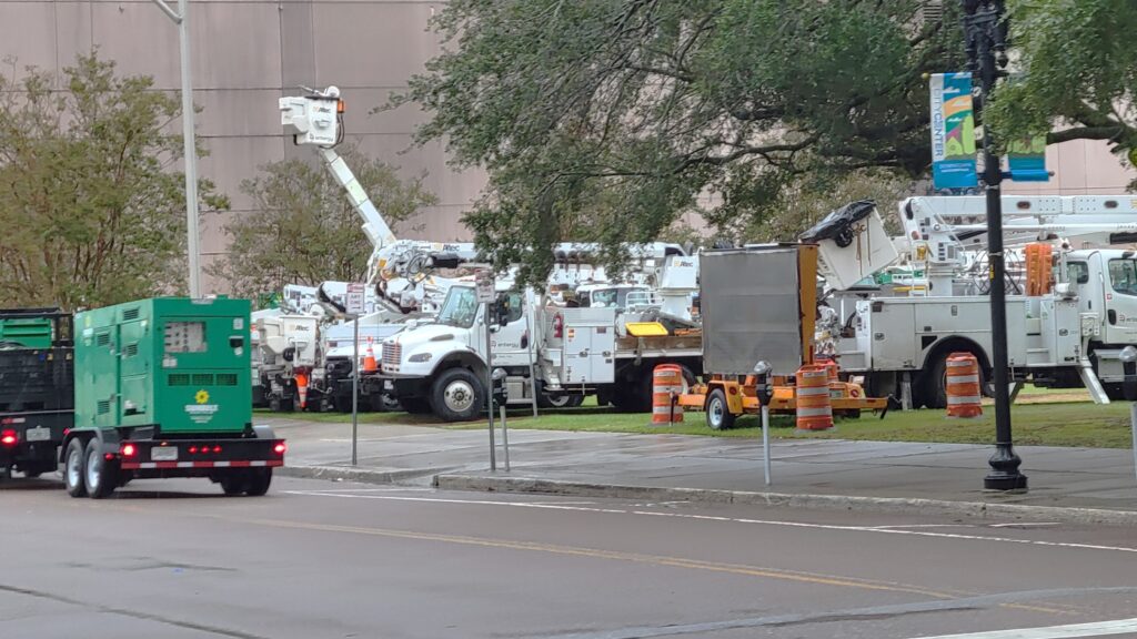
Power: JEA has lined up 300 contract lineworkers and tree trimmers to work with its utility crews on outages. They will work until wind conditions go above 30 mph, then resume work on Thursday morning as winds die down.
JEA announced that it is continuing its suspension of disconnections for non-payment, begun after Hurricane Helene less than two weeks ago, in light of the new storm.
To report power outages during Milton:
- Visit jea.com/outage to view JEA’s Electric Outage Map and report an electric or water outage
- Call (904) 665-6000 to use the automated system
- Text OUT to 69532 (MyJEA)
Construction cranes: Deegan said she has heard concerns about the safety of tall construction cranes working on the Four Seasons Hotel and adjacent office building on Gator Bowl Boulevard. She said they have been tied down, and that the expected wind speeds would have to be “much higher for those to be an issue in terms of collapse.”
Police: The city will have more than 90 more officers on patrol Wednesday night and Thursday morning to block flooded roads and other storm duties. The city also has staged multiple emergency access road teams to clear obstructions so JEA crews can get to powerline issues.
The Jacksonville Fire and Rescue Department has Swift Water and Urban Rescue teams standing by to help stranded drivers or homeowners in floodwaters. Some probably will be deployed to Southwest Florida to help there.
“It’s going to be a couple of very long days for them, and some even more because they will be headed out to help others that get more hard hit by these storms,,”Deegan said. “We are truly, truly grateful for these teams.”
Blood collection: LifeSouth Community Blood Centers and OneBlood are urging the community to give blood now to help prepare, as blood collections will be affected during and after the storm. Donating ensures blood will be available to help patients suffering from traumas, cancers and chronic illnesses. All blood types are needed, especially type O donors and platelet donors.
For additional information, keep an eye on jaxready.com for updates from Duval County emergency managers.
Clay County
Clay County was preparing for flooding along Black Creek and the St. Johns River. No evacuations have been ordered, but people in low-lying areas and along Black Creek and the St. Johns were encouraged to relocate.
The eastern side of the county could see stronger tropical storm-force winds, according to Emergency Operations Center Director Timothy Devin. Flooding could continue into the weekend. Water levels will be updated at alert.claycountygov.com. B
Shelters: Four shelters opened at 6 a.m. Wednesday:
- Orange Park High (pet friendly).
- Keystone Elementary (pet friendly).
- Lake Asbury Junior High (special needs).
- Wilkinson Elementary.
Schools: Clay County schools will be closed Wednesday and Thursday.
Garbage pickup: Crews will run pickups on Wednesday as long as it’s safe.
Nassau County
No evacuations have been ordered, but officials strongly recommend that people who have power-dependent special needs or live in low-lying or flood-prone areas leave.
Shelters: A shelter has been set up at Wildlight Elementary on Curiosity Avenue in Yulee.
St. Johns County
St. Johns County ordered the evacuation of the entire city of St. Augustine as well as St. Augustine Beach, Ponte Vedra Beach and residents living on waterfront properties or in flood-prone areas.
The order applied to all residents and visitors in Evacuation Zones A and B, as well as Zone F (only south of State Road 206). It took effect at 8 a.m. Wednesday, the same time that emergency shelters opened:
- Special Medical Needs: Freedom Crossing Academy, 1365 Shetland Drive, St. Johns. (Eligibility: Not all individuals are eligible to utilize the Special Medical Needs Storm Shelter. Space is reserved for those who rely on electricity for medical equipment or require oxygen therapy. The Special Medical Needs Storm Shelter is not a substitute for regular health care. Basic medical assistance and monitoring will be available, but individuals must come with a caregiver to ensure they maintain their accustomed level of care. Shelter staff will not be able to provide one-on-one care.)
- Pet Friendly: South Woods Elementary School, 4750 State Road 206 W., Elkton.
- General Population: Pedro Menendez High School, 600 State Road 206 W., St. Augustine.
Schools: St. Johns County schools are closed Wednesday through Friday.
Garbage collection: Recycling collection is suspended through Friday. County officials said resources will be redirected to collecting yard waste. Garbage collection will remain on its regular schedule.

Randy comes to Jacksonville from the South Florida Sun-Sentinel, where as metro editor, he led investigative coverage of the Parkland school shooting that won the 2019 Pulitzer Prize for public service. He has spent more than 40 years in reporting and editing positions in Illinois, Iowa, Missouri, Ohio and Florida.