Published on September 26, 2024 at 10:10 am
Free local news and info, in your inbox at 6 a.m. M-F. Sign up for the Jacksonville Today newsletter.
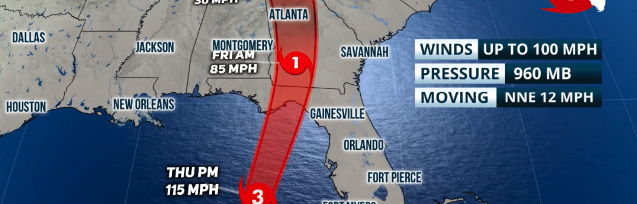
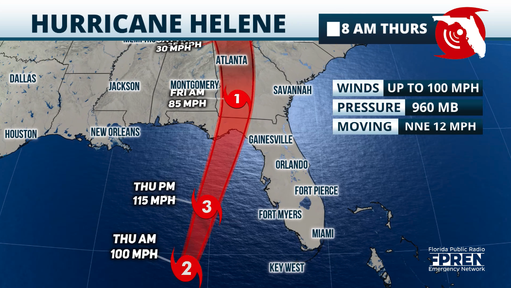
Hurricane Helene, with maximum sustained winds of 100 mph, is on the verge of becoming a Category 3 hurricane as it races northward over the Gulf of Mexico.
Helene is 320 miles southwest of Tampa and will be parallel to Tampa, but staying about 150 miles west of Tampa around 3 p.m. Thursday, according to the Florida Public Radio Emergency Network.
Jacksonville Today thanks our sponsors. Become one.
The hurricane will continue to strengthen Thursday, likely reaching maximum sustained winds of at least 130 mph by the time it lands tonight along the Florida Big Bend, likely between Bald Point State Park and Eastpoint.
Although Northeast Florida remains outside the forecast cone, Helene is so large that severe weather is expected far to the east, including Jacksonville and Southeast Georgia.
The National Weather Service in Jacksonville predicts flooding in the St. johns River Basin and along the Atlantic Coast.
Jacksonville Today thanks our sponsors. Become one.
As Helene nears landfall Thursday evening, water will be pushed from the upper St. Johns northward, which could lead to flooding along low-lying areas along the river, particularly Downtown Jacksonville.
Isolated to scattered tornadoes are possible across the region, the Weather Service says. The highest potential for tornadoes will be along coastal Duval County and coastal areas of Southeast Georgia, especially from 5 to 11 p.m., the Weather Service says.
Heavy rainbands have been moving along the Florida Peninsula all evening, and gusty winds have been felt all along the east coast of Florida.
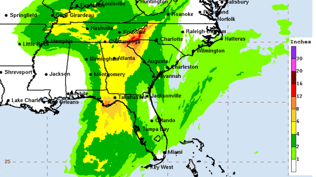
The amount of rainfall predicted in Northeast Florida has trended down to 1 to 2 inches, according to the National Hurricane Center. But the soil is so saturated from recent rain increases the chances of localized flooding.
Driving conditions could become hazardous on Thursday and Thursday night with heavy rainfall and potentially flooded roads, the Weather Service advises.
Winds of at least 39 mph are forecast in Northeast Florida beginning early Thursday afternooon. Stronger winds will continue to affect the west coast, which will be the trend as Helene heads to the Big Bend.
Within the rainbands, embedded thunderstorms could develop tornadoes. A tornado watch has been issued for all of Northeast Florida and Southeast Georgia until at least 10 p.m. Thursday.
If you are in a safe structure, stay there until warnings have been canceled for your location. Ensure you have at least three ways of receiving weather alerts, and keep your mobile devices charged.
In case cell towers are down, remember that text messages are the best way to communicate and limit your phone usage to save its power.
Helene across Florida
Tropical storm-force gusts will continue along the Southeast, Treasure Coast and Space Coast. Tropical storm-force winds, meaning sustained winds of at least 39 mph, are possible along Southwest Florida and inland Central Florida.
Meanwhile, the Central-West Coast could experience winds between 58 and 75 mph. There will be widespread power outages across much of the Florida Panhandle, possibly for several days. Weather will quickly deteriorate on Thursday as the storm nears. Being outside will be dangerous.
 The storm surge along portions of the Big Bend coast will be catastrophic and life-threatening, possibly reaching up to 20 feet. As Helene tracks north, a dangerous and damaging storm surge will affect the entire west coast of Florida.
Rainfall also will bring flooding across parts of Florida. August and September have been busy months regarding rain and flooding across parts of Florida´s West Coast.
The ground is already well saturated, so the forecast amounts between 2 and 6 inches from Southwest Florida through the Tampa Bay area will cause flooding, possibly even flash floods.
Also, rivers, lakes and creeks will increase their levels, some already high. Flood stages will quickly increase, making conditions dangerous for those nearby.
Copyright 2024 Storm Center

Randy comes to Jacksonville from the South Florida Sun-Sentinel, where as metro editor, he led investigative coverage of the Parkland school shooting that won the 2019 Pulitzer Prize for public service. He has spent more than 45 years in reporting and editing positions in Illinois, Iowa, Missouri, Ohio and Florida.