This past Labor Day weekend broke a hurricane seasonal record, not for activity, but lack of it.
For the first time in almost three decades, there wasn’t a tropical storm in the Atlantic basin between Aug. 21 and Sept. 2. That hasn’t happened since 1997, more than 27 years ago.
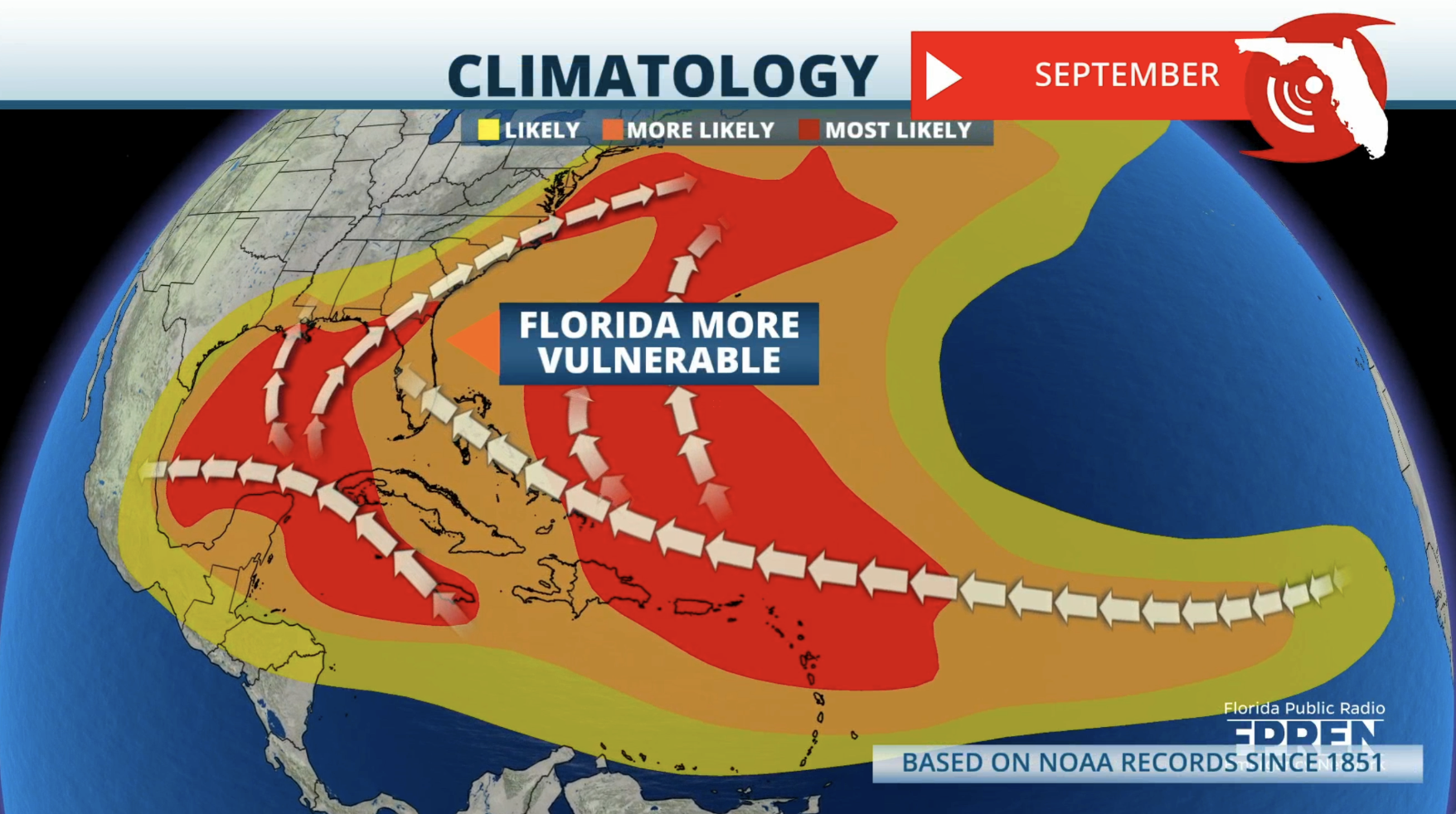
As you probably know, historically, September is the most active month of the Atlantic hurricane season and this month is statistically the most likely for a hurricane to form. More “real estate” is available for tropical development in September than any other month, so it’s no surprise that hurricane season will peak next week, on Sept. 10.

On average, the Atlantic hurricane season has seven named tropical storms by Sept. 24, including four hurricanes. So far, we’ve had five named tropical storms and three hurricanes, one of which, Beryl, became a major Category 5 hurricane.

It’s important to note that the 2024 Atlantic hurricane season has already brought significant impacts:
- Tropical Storm Alberto formed on June 17, bringing nearly a foot of rain and flooding parts of Texas and New Mexico. The tremendous amount of rainwater triggered several flash flood emergencies.
- On July 1, Hurricane Beryl became the earliest Category 5 storm on record to form in the Atlantic basin. Beryl caused catastrophic damage and approximately 20 fatalities in several islands in the Caribbean Sea, with an additional preliminary death toll of about 25 people in Texas, Louisiana and Vermont.
- Hurricane Debby was also a catastrophic hurricane, causing at least 9 fatalities and over 28 billion dollars in damages.
September is known for producing the most intense Atlantic hurricanes all season. August and September are known for developing the famous Cabo Verde storms.
Some of these tropical systems take a 3,500-mile-long journey from the eastern tropical Atlantic Ocean toward the islands of the Caribbean or the United States coastline, while others curve northwestward toward Bermuda or the open ocean.
These storms that live in the Atlantic basin for several weeks often become quite powerful and dangerous. Some of the most notorious Cabo Verde storms in recent history included catastrophic Hurricane Dorian, Hurricane Ivan, and Hurricane Andrew.
Another hot spot for tropical storms and hurricanes to form is the Gulf of Mexico, particularly the northern Gulf of Mexico to the south of Louisiana and Mississippi, as water temperatures in the Gulf reach the highest levels of the year.

Some of the factors that go into making September a month to remember is that the ocean’s surface temperature peaks in early to mid-September, reaching temperatures of 80 degrees or higher in the Caribbean and Gulf of Mexico.
But this year, we met that threshold in June. Atmospheric conditions also become more favorable as vertical wind shear tends to relax more during mid season which allows more tropical systems to form and grow.

The well advertised Saharan dust is also playing a factor in this year’s hurricane season. The Saharan dust is some 60% to 70% dustier this year than in previous years. That, coupled with a slower-than-expected progression to a La Niña pattern, has caused more wind shear in the first half of the season, slowing the formation of storms. You can read more about the Saharan dust here:
Saharan dust and its impact on the 2024 hurricane season
Hurricane experts say it’s critical to stay vigilant this hurricane season. Statistically, there should be another eight to 10 named storms, according to the National Hurricane Center. And of those, two to four systems could have direct effects on the United States this season.
Next week: Look for an article about peak hurricane season and what we can expect between now and Nov. 30.


