Published on August 1, 2024 at 5:15 pm
Free local news and info, in your inbox at 6 a.m. M-F. Sign up for the Jacksonville Today newsletter.
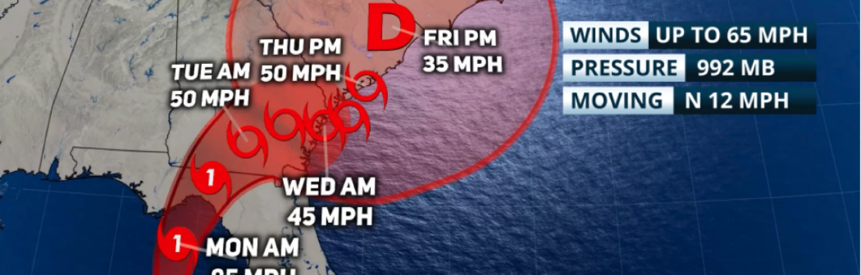
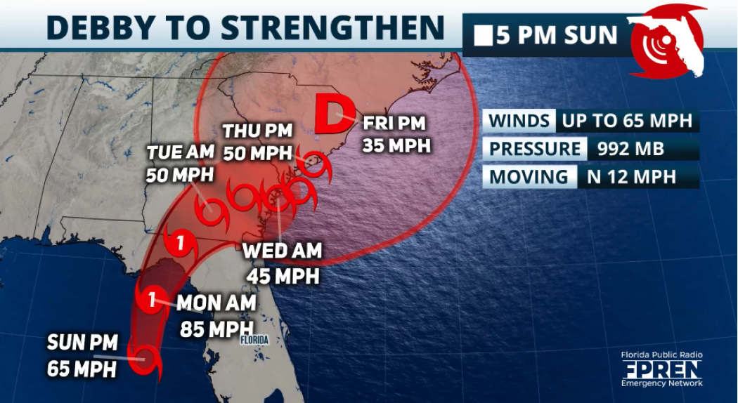
As of 8 p.m., Tropical Storm Debby has started to intensify. It now holds 70 mph winds and it is on the verge of becoming a hurricane. Further intensification, is likely rapidly to occur during the next 8 – 10 hours until it makes landfall near the Florida Big Bend Monday around noon. Debby is still moving to the north and will start to shift to the northeast as it loses forward speed. A major flooding threat is expected during the beginning of the week across the Southeast.
Conditions are favorable for tornadoes to develop overnight across Central and
North Florida. The National Weather Service has issued a tornado watch, in effect until 6 a.m. Monday.
Jacksonville Today thanks our sponsors. Become one.

By Monday at noon, Debby will be located about 20 miles inland just to the southeast of Tallahassee. This is when conditions start to get more dangerous, even with a storm that will be losing its windspeeds as it interacts with land, the heavy rains will be falling over the same places, for a prolonged period. According to Sunday morning’s forecast by the National Hurricane Center, the storm would move about 60 miles in 12 hours. This is when the largest rainfall will fall for North Florida and the eastern portion of the Panhandle. Central Florida can expect to receive up to 8 inches across its northern fringes, while cities like Orlando would stay closer to the 4-inch mark.

Expect heavy rain bands to continue affecting the state with storms moving quickly through and some of these storms could have tornadoes embedded in them. The biggest threat for tornadoes will be on Sunday night and through Monday morning from the Fort Myers area to Tampa through central Florida and covering from just east of Tallahassee to Jacksonville. Keep in mind that with the tornado risk, there is also the risk for some thunderstorms to produce gusty winds that can cause damage.

This storm, regardless of intensification will be a big rain event. There will be significant winds across North Florida, hurricane-force, but the system is expected to downgrade to a tropical storm once it moves over the state and continues crawling across southern Georgia, and South Carolina. Forward speeds will drop quickly, and it will likely move at about 5 mph or so. The highest risk for flash floods will be over the Big Bend and North Florida, where there are some areas where up to 12 inches could fall.


Jacksonville Today thanks our sponsors. Become one.