Published on January 8, 2024 at 1:22 pm
Free local news and info, in your inbox at 6 a.m. M-F. Sign up for the Jacksonville Today newsletter.
Just a few days after a cold front brought heavy rain to the Sunshine State and a few strong thunderstorms, including one that spawned a tornado over Fort Lauderdale, another storm system is taking aim at Florida.
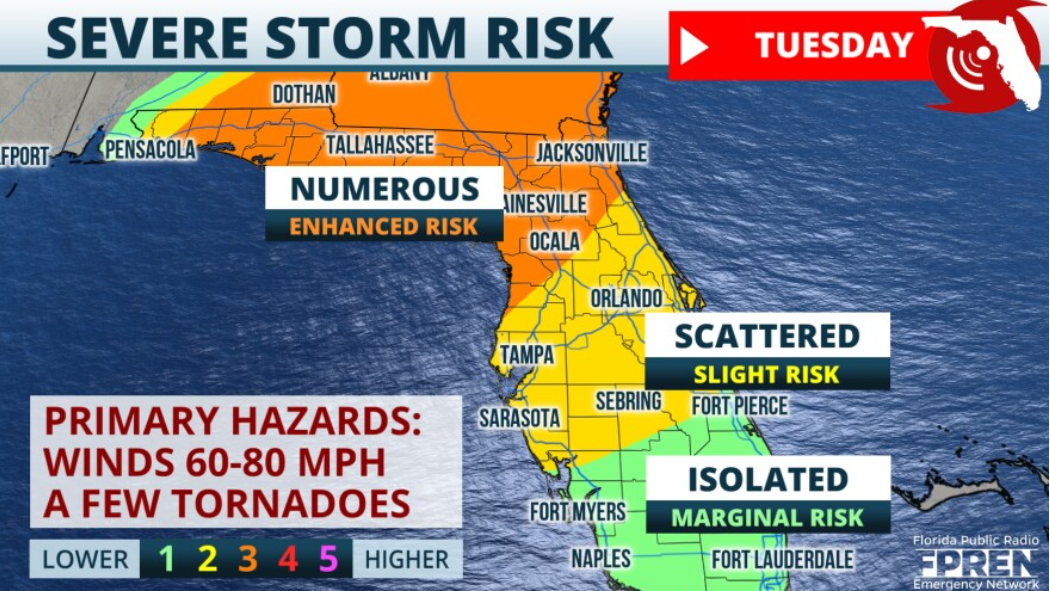
This one is forecast to be much stronger than its predecessor. Strong straight-line winds, large hail and a few tornadoes, some of which could be strong, are all possible as the next storm system affects Florida Monday night and throughout the day Tuesday.
Jacksonville Today thanks our sponsors. Become one.
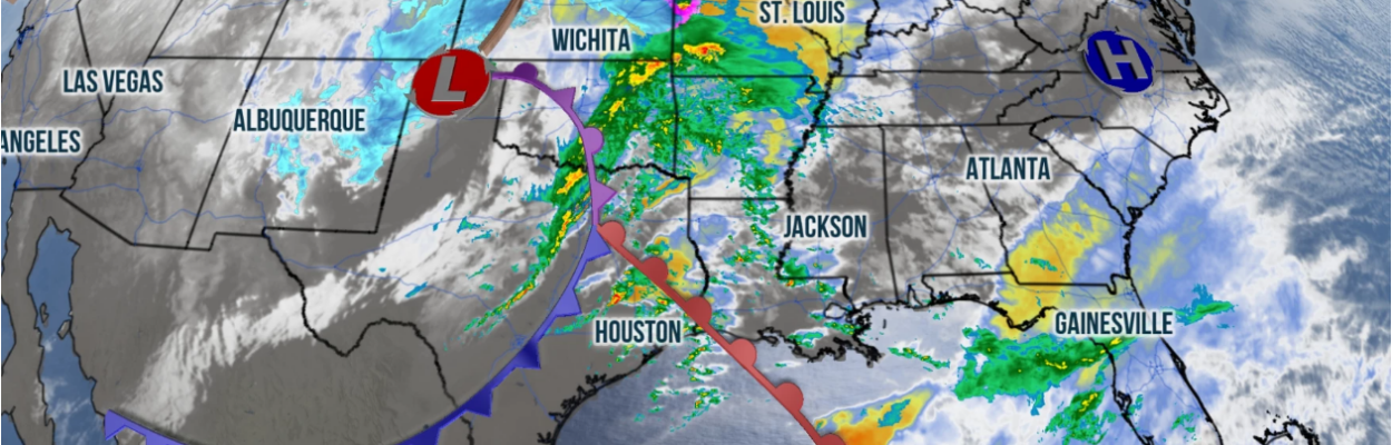
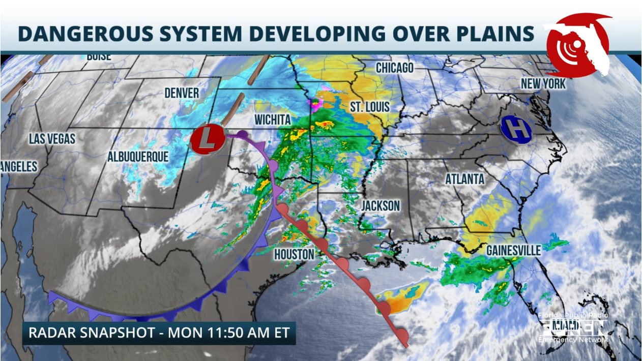
On Monday morning, an intense mid and upper-level disturbance was positioned over the Southern Plains. Winds in the mid and upper levels were quite strong, and a warm and humid airmass from the Gulf of Mexico was being drawn northward.
At the same time, surface low pressure was deepening over the Southern Plains. Widespread rain and thunderstorm activity was already being produced by the system over eastern Colorado and New Mexico, and throughout Kansas, Oklahoma, and Texas.
Through the day Monday, the surface low was forecast to intensify, aided by the strong disturbance in the mid and upper levels. The core of the system should track through the Plains toward the Midwest, dragging both a warm front and a cold front through the Central Gulf Coast and Southeast. The passage of both these fronts will produce the threat for multiple rounds of severe weather across parts of Florida Monday night and Tuesday.


Jacksonville Today thanks our sponsors. Become one.
Round I: Warm front passage
As of the latest model guidance, a strong warm front should lift from south to north through the length of Florida overnight Monday into the predawn hours Tuesday. Widespread light to moderate rain rates are expected from the Panhandle to North Florida during this time; however, the environment will be able to support a few rotating thunderstorms.
As such, there is an isolated risk for hail, damaging straight line winds, and stray tornadoes overnight Monday into early Tuesday over the Panhandle and North Florida as the warm front tracks northward.
Round II: Cold front and potentially dangerous squall line
Forecasters at the Storm Prediction Center and local National Weather Service offices are more concerned with hazards posed by and directly ahead of the second round of storms.
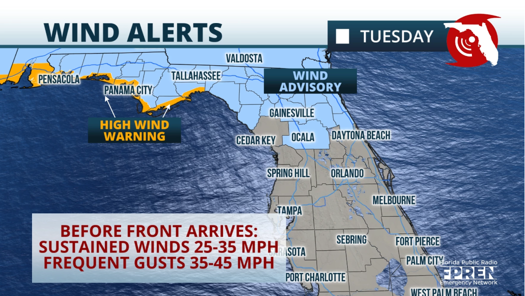
After the warm front lifts northward, a cold front should barrel through the state of Florida from west to east. Directly ahead of this boundary, winds are expected to stiffen. Sustained winds of 25-35 mph are likely, and frequent gusts between 35 and 45 mph are possible.
 Wind alerts have already been issued for the Panhandle and North Florida, valid for most of the day Tuesday. These conditions should immediately precede a squall line of dangerous thunderstorms directly along the leading edge of the cold front.
As of observational and forecast data from Monday morning, the primary hazard from these squall line thunderstorms will be straight line wind gusts between 60 and 80 mph. These conditions could down tree limbs, trees and power lines, and any unsecured objects may be lofted into the air. Scattered power outages are possible. In addition, a few strong tornadoes and isolated instances of large hail are not out of the realm of possibility.
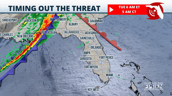
The latest time of arrival forecasts are as follows:
- Pensacola: 10 p.m.-1 a.m. CST for warm front storms, 4 a.m.–6 a.m. CST for squall line.
- Panama City: 11 p.m.–1 a.m. CST for warm front storms, 5 a.m.–7 a.m. for squall line.
- Tallahassee: 3 a.m.– 7 a.m. EST for warm front storms, 9 a.m.-noon EST for squall line.
- Jacksonville: 2 p.m.–5 p.m. EST for squall line.
- Gainesville: 2 p.m.–5 p.m. EST for squall line.
- Tampa: 6 p.m.–9 p.m. EST for squall line.
- Orlando: 6 p.m.–9 p.m. EST for squall line.
- Melbourne: 6 p.m.–9 p.m. EST for squall line.
- Fort Myers: 9 p.m. to 1 a.m. Wednesday for squall line.
- Fort Pierce: 9 p.m. to 1 a.m. Wednesday for squall line.
- Miami: 11 p.m. to 5 a.m. Wednesday for squall line.
Readers are encouraged to continue checking the forecast, as details may change. In addition, we encourage everyone to check to insure they have multiple ways of receiving weather alerts and are prepared to quickly seek shelter if a severe thunderstorm or tornado threatens their area.
Copyright 2024 Storm Center. To see more, visit Storm Center.9(MDEwNzczMDA2MDEzNTg3ODA1MTAzZjYxNg004))