Published on September 24, 2024 at 11:19 am
Find everything you need to make informed decisions this election season, plus so much more. Sign up for the Jacksonville Today newsletter.
Potential Hurricane Helene continues to strengthen and could bring possible tropical storm winds and heavy rain to Northeast Florida by late this week.
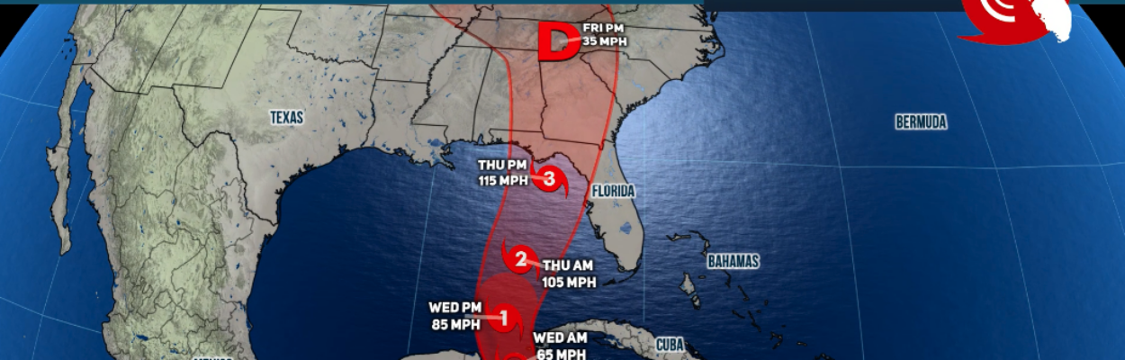
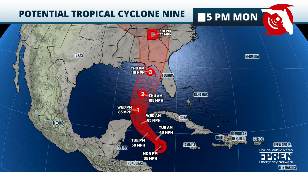
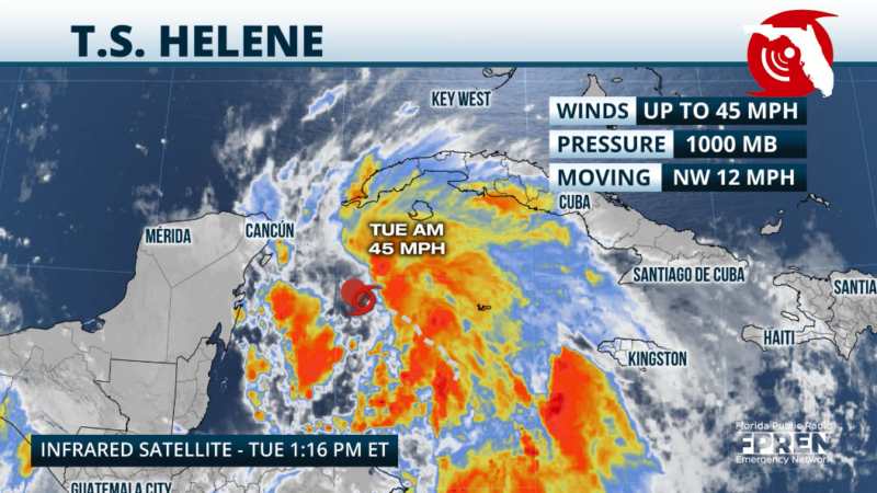
The storm was about 170 miles south-southeast of the western tip of Cuba as of 11 a.m. Tuesday. It had maximum sustained winds of 45 mph and was moving northwest at about 12 mph.
Jacksonville Today thanks our sponsors. Become one.

A similar movement is expected during the next 24 hours, but the system will be gaining strength. It was named Tropical Storm Helene in an 11 a.m. update from the National Hurricane Center.
Once the system enters the Gulf of Mexico it will travel over very warm waters and there won’t be much to stop it.
The National Hurricane Center warns that this system could rapidly intensify and become a Category 3 hurricane as it moves over the eastern Gulf of Mexico.


Jacksonville Today thanks our sponsors. Become one.
A tropical storm warning was in effect for Dry Tortugas and the Lower Keys west of the Seven Mile Bridge. Watches will continue to be issued overnight and into Tuesday, especially across the West Coast of Florida.

Once over the eastern Gulf of Mexico, the system will not only intensify, but it will gain forward speed. A faster northward to north-northeast direction is expected on Wednesday and Thursday.

Helene impacts
Any shift to the track, either west or east, would change the impacts for the state. A shift west would bring lesser impacts, and a shift to the east would bring more impact to Florida.
The largest storm surge is expected from Southwest Florida through the west coast of the state, including the Tampa Bay area. Under the current track, there could be areas that experience greater than 9 feet of storm surge, especially across Matagorda Bay, the Tampa Bay area and the Big Bend.
For Southwest Florida up to 3 feet of storm surge is possible under the current track.

It is still early to pinpoint the exact rainfall for this system. Currently, the greatest rainfall would fall between the Florida Panhandle and the Big Bend area. But this also includes North Florida, where there could be up to 8 inches of rain.
Two to 4 inches of rain are forecast in Northeast Florida. Tropical storm-force winds — meaning at least 39 mph — are expected to arrive here during the day Thursday.
Keep in mind the system will be moving much faster than other recent tropical systems. Therefore, rainfall is not expected to be as heavy, but still, keep in mind that the ground has been very saturated across the Panhandle of Florida in recent weeks and flooding will rapidly occur.
The west coast of Florida also will be dealing with the risk of flash floods as the heaviest bands will move through the area from Tuesday evening through Friday morning.
Expect tropical storm-force winds to begin across the Keys as early as Wednesday morning. By Wednesday evening, all of South Florida including Southwest Florida could be experiencing storm-force winds, and winds will propagate through the state, northward, and intensify overnight into Thursday.
The strongest winds will be near the eye wall and to the right of the storm. The wind field will be large, therefore, much of Central Florida through North Florida could feel at least tropical storm-force winds and some spots will deal with hurricane force-winds as the storm approaches the coast on Thursday afternoon
Please make sure to finish your preparations by Wednesday afternoon if you are north of Lake Okeechobee. If you are south, finish them by Wednesday morning.
Copyright 2024 Storm Center
